


HOW MANY TIMES CAN YOU PULL THAT FOOTBALL? WINTER STORM UPDATE...
- Feb 23, 2020
- 4 min read
JOIN US FOR A NEW EDITION OF WEATHER SCHOOL: SEVERE STORMS 101:

We have a brand new weather school planned for April 4th. This one is called Severe Storms 101. If you want to know more about the ins and outs of severe thunderstorms and how to forecast them this will be a great introductory session. There will be event simulations and a big focus on tornadoes. Some tips on chasing them as well. Aside from that there will be in depth focus on the 1968 EF5 Charles City tornado outbreak, the Parkersburg EF5 of 2008, and the rare mid-November EF4 Washington, Illinois twister that occurred November 17, 2013. Lots of compelling video and insights presented by 3 meteorologists. Contact Carolynswettstone@yahoo.com to sign up or click on the more details button in the graphic above to find out more!
HOW MANY TIMES CAN IT HAPPEN!!!
Straight up there's lots going on and chaos abounds regarding Tuesday's winter storm. I don't like the smell of it. Here's my thinking and a bit of how we got here...
In response to the threat of heavy snow, a winter storm watch has been issued by the NWS for much of the area Tuesday/Tuesday night.

The text reads, note the line the storm has the potential to be one of the strongest winter storms of the season so far.

The watch area has also been expanded north and west.

Here'e the rub...
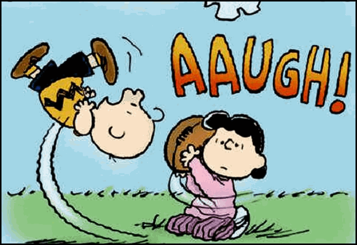
While this could still be the strongest storm of the winter in some areas, I have fresh trends that have me concerned it might not be in mine. As you all know, the past few days all the models have been staunch about my entire area in Iowa and Illinois getting clocked with heavy snow. However, I have said over and over again...be leery of phasing, or lack of it. This has been a huge issue in modeling this year. Time and time again, just like Lucy pulling the football from Charlie Brown, at the last second it can cause a whiff! Auugh
If the EURO is right, the first signs of trouble are showing up. Slower phasing is taking the system further south on that model and that is taking eastern Iowa out of the heavy snow. That's a large part of the region that is in the winter storm watch. A potential whiff?
Because of this phasing concerns, I have also been saying I would not be on board with any placement or snow amounts until Sunday night!!! The only thing I committed to was there would be a storm and if the trends held through today it would impact much of my area in a big way.
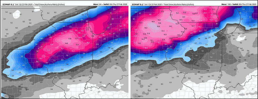
Look at what the EURO is showing today on the left compared to what it showed 24 hours ago on the right. That is a huge and dramatic change. In some parts of eastern Iowa amounts went from 16" to less than an inch. I about fell off the chair when I took that gut punch!
Now the area from the Quad Cities southeast still gets popped but another run like that and even there the amounts go down again. Of course there is a chance it could come back northwest and increase amounts but that possibility seems very remote.
In fact, the GEM (Canadian) which was also very bullish in eastern Iowa yesterday is now in the EURO camp. Here's what the 2 models show for raw snow totals.
The EURO

The GEM (Canadian)

On the flip side the 3K NAM, the 12k NAM, and GFS have not caught the trend and remain much further west in Iowa with the heavier accumulations. Here they are.
The 3k NAM

The 12k NAM

The GFS

I suspect it's just a matter of time before those U.S. based models pick up on the trend and shift east. I will be very surprised if they don't go the way of the EURO and GEM later today or tonight.
SO WHAT'S THE VERDICT?
They say the trend is your friend and we are now getting to that point where the trends are not likely to reverse, If anything, the recent ones could continue to magnify with even less phasing and cut into snow amounts over western Illinois. That is a concern worth watching.
What I am seeing now is far different than what the winter storm watches indicate and what you are hearing from other sources. I personally think this is going the wrong way and I'm cutting bait as fast as I can. I could be wrong and won't be fully sure how this plays out until tonight. But for now, I feel that football being pulled out in a lot of places west of the Mississippi.
If nothing changes going forward, I think only far south-eastern Iowa gets in on totals that could be in the 2-4" range southeast of a line from Washington, Iowa to north of Savanna, Illinois. NW of there the 1-2" line may make it back to Cedar Rapids but by the time you get to Waterloo its under 1". Around the Quad Cities 3-5" amounts are still possible with even heavier amounts further east into Illinois.
This whole debacle has really lowered confidence in the overall scenario and I look for more changes going forward. The winter storm watch may eventually be dropped in some parts of eastern Iowa especially NW of a line from Ottumwa to Iowa City and on to the southeast of Dubuque.
The bottom line, snow is still on the table for far southeast Iowa and much of Illinois but is looking lighter and less likely in eastern Iowa. I live in the black hole of weather. Anyway, these are the latest trends and I'm trying to get out in front of all this. Roll weather...TS


Comments