


A STINGER...
- Dec 18, 2025
- 4 min read
Despite the beautiful weather we experienced Wednesday, the Accumulated Winter Storm Severity Index (AWSSI) remains in the extreme category from Iowa and Illinois through the Great Lakes, Ohio Valley, and Northeast. Extreme, indicating the persistence of cold and snow in the pattern so far this winter.
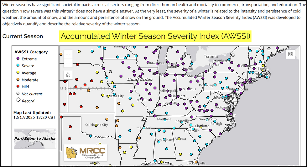
The (AWSSI) was developed to objectively quantify and describe the relative severity of the winter season on a running basis.
Goals of the AWSSI
Use max/min temperature, snowfall, and snow depth to objectively index winter weather conditions.
Create a historical database of AWSSI for locations with available temperature, snowfall and snow depth.
Compare season to season AWSSI for a particular location in climatological context.
Due to the exceptional cold and snow of the past 3 weeks, my entire area is currently listed in the extreme category (level 5 of 5). Ratings go back as far as 1950, and you can see that Moline has a current score of 204, which is in the top 10 percent of 75 winters through December 16th. The all-time highest score at this point was 276. The lowest 15.

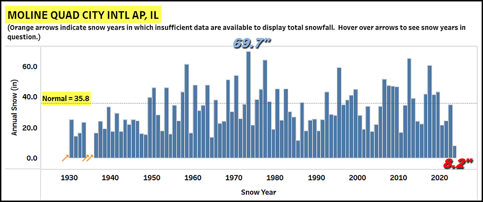
By the way, so far in Moline 18.6 inches of snow has fallen, that's more than half of the winter average which is 35.8 inches with a long way to go before the last flake flies. Going back to 1930, the most snow in a season is 69.7 inches in 1974-75 and the least was just last year with a paltry 8.2 inches.
GIVE THE GIFT OF MY 5 STAR AIRBNB IN GALENA

Holiday and winter specials are now in effect through March. Let us help you set up a personalized gift certificate that's sure to create a lifetime of memories! Santa Claus approved. Call or text Carolyn at 563-676-3320 for details and our very best pricing. https://www.littlewhitechurchgalena.com/
WHERE DO WE GO FROM HERE?
There's no doubt that the near future is looking far better for a more moderate brand of weather. In fact, I would be willing to bet that by early January the winter severity index will be out of the extreme category and no worse than severe, thanks to a prolonged period of above normal temperatures and little if any snowfall through the first few days of January.
Before we get to the teeth of the warmth that's coming just before Christmas, we do have what I call a stinger arriving Thursday morning. You can see it at 500mb digging rapidly into the Midwest over the next 24 hours, buckling the jet and allowing a quick, but stout shot of cold air.

Due to the fast movement of the energy and a rapid fall and rise in pressures, the system will bring a round of strong winds. Already, south winds tied to warm advection have brought clouds and showers into the area overnight. These will linger into Thursday morning until the stinger and its cold front punch through from west to east during the morning. Temperatures start mild in the low 40s north to near 50 south. However, readings begin to fall by afternoon as we abruptly feel the effects of cold air advection and wind gusts to 45 mph. By evening temperatures are the low 20s north to upper 20s south. It is also possible that the strong cold air advection could squeeze out some scattered snow showers. Friday morning lows of 6 north to 12 south are expected, along with sub-zero wind chills that should reach 10-15 below north of I-80. Highs Friday look cold, with readings around 20 in the far north to the upper 20s south.
It does not appear precipitation Thursday morning will be overly heavy due to the fast movement of the stinger, but rainfall amounts of 1/4 to 1/3rd of an inch are possible, perhaps some local spots with up to 1/2 inch east of the Mississippi. Any snow would be nothing more than a dusting, if that in the northwest. Here's what models are suggesting for rain totals.
The EURO

The GFS

The 3K NAM

The HRRR

The NBMv5, a blend of 30 models and ensembles.

With that system out of the way, the fast moving jet sends another disturbance across the upper Midwest that drives highs above freezing Saturday. On its backside, another pop of cold air advection lowers readings Sunday in a classic push-pull pattern.
Finally, there is good consensus that the period December 23rd though the 25th is dominated by rising heights at 500mb which results in a building ridge and much above normal temperatures for Christmas, a trend that's been indicated for numerous days. This is the 500mb jet stream flow on the EURO Christmas morning that delivers the mild air.

Temperatures Christmas day are projected to be 17 to 26 degrees above normal locally.

That leads to highs in the mid 40s north to the mid 50s south. Not good sledding for old St. Nick.

Additionally, after the rains of Thursday, little if any precipitation is indicated through Christmas Day. Holiday travelers during the period December 19th through the 25th should expect excellent driving conditions through the central Midwest. Here's what the EURO shows for precipitation.

Well, today won't be much of a day with morning rain, followed by wind, and falling temperatures in the afternoon. The good news is that this time around, you won't have to do any shoveling. Roll weather...TS
TSWAILS.COM expert weather consulting services (CLICK FOR MORE)

Private consulting
Legal forensic services as an expert witness
Public speaking engagements for groups or individuals
Post storm analysis
A private day-long weather school class
Specialized events forecasts
Severe weather seminars
Lectures and training
Climatological services
Meteorological workshops.


Comments