MELTING IN THE MIDWEST!
- Mar 1, 2020
- 2 min read
We had a nice mild start to March in the Midwest. It was the warmest day since late October (last time we were in the 60s was October 20th, last time we were in the upper 50s was Christmas Day). This was the warmest start to March in 27 years, since 1992 (when temperatures were in 60s and 70s).

You can see where the snowpack is still in place - temperatures were held in the low 40s in far northern Iowa into southern Minnesota. A lot of the snow has been melting over the last week or so with mild temperatures in place. We will continue to melt as the new week goes on.

That deep deep snowpack in the far north is largely unaffected, but a lot of northern Iowa/southern MN/WI will see the snow melt away. Temperatures will be near and above freezing for much of the week. A cold front that moves through early Monday will knock back temperatures (so we won't be as warm as Sunday) but we'll still be mild for early March standards.

The first week or two of March looks to be on the mild side. This is the Climate Prediction Center outlook through March 11:

Here's the temperatures on the European model for Cedar Rapids and the Quad Cities as an example:


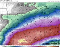
There will be some ups and downs happening during the week but little to no precipitation is expected. The Euro is trying to show a quick moving clipper Tuesday night into Wednesday.

So some parts of the Midwest may pick up a little rain or snow, but temperatures are largely unaffected. We'll have to see how long the mild weather hangs on and how much more melting we do.
RK


Comments