WHAT GOES UP, MUST GO DOWN...WAY DOWN!
Short term the weather is fairly straight forward across the central Midwest with the key theme being a return to summerlike temperatures, albeit a brief flirtation. Before the warmth arrives a fly in the ointment is a disturbance that streaks across the region Thursday bringing the threat of some scattered showers. Here's what it looks like on the satellite Wednesday night.

Models are in general agreement that the best moisture and forcing remains to the north and that being the case any rain that falls is likely to be light and confined to the area near and north of HWY 30, especially north of HWY 20 where the potential for slightly higher totals exist. It won't be much. The EURO shows this for amounts

Once this disturbance gets to the east the door is open for some toasty temperatures to start the weekend. With brisk southwesterly winds and low to moderate humidity highs should easily get into the 80s Friday. On Saturday, with 850 temperatures exceeding 20 degrees readings could approach 90, especially across the SW half of my area.
Sunday, what looks to be a fairly dry frontal passage heralds the arrival of a significant pattern change that will have us chilling out as we close out September and slide into October. Anytime you see a high amplitude trough like this as a meteorologist you need to wipe your chin a bit.

Look at the temperature departures this creates in about a week.

The change is also very evident in the 5 day temperature departures. Through Monday days 0-5 look like this.

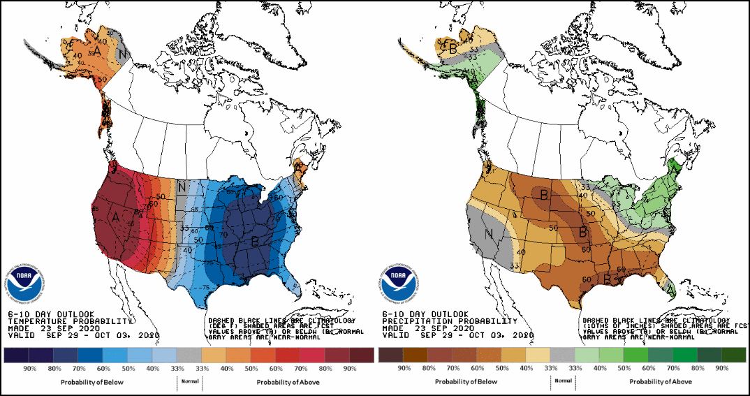
Days 5-10...Monday through Saturday of next week we revert to this.

Days 10-15 are not much better out to October 9th.

If the pattern evolves as shown Wednesday night, the growing season could come to an early end at some point during the 8-15 day period. The GFS has this for lows Friday October 2nd.

The first snowflakes of the season are possible in some parts of the upper Midwest. Perhaps an inch or two on grassy surfaces in the northwoods of Wisconsin.

Another off-shoot of this type of pattern is the extreme warmth that will exist over the southwest U.S. where we are entering the peak of the fire season.

The strong western ridge will promote Santa Anna winds and I'm very concerned about the potential for significant wild fires. These are trying times indeed. Get your dose of summer Friday and Saturday, days like them will be few and far between in the months ahead. Roll weather...TS


