ALL BURNED OUT....
- May 13, 2022
- 3 min read
Well, we did it again Thursday. Intense early season heat sent highs to record breaking levels over much of the area for the second consecutive day. Here's the record set or tied. The NWS office in Davenport reached 97. The only reason that's not a record is that data has not been recorded long enough at that site to make it official.
MOLINE.................95 (94, 1956)
DUBUQUE.............93 (90, 1896)
CEDAR RAPIDS....93 (90, 1896)
While heat index values did hit 100 dew points mixed out late in the day falling from the low 70s to the mid 60s thanks to a brisk south wind that reached 30 mph. It was a hot wind, the kind you see a lot of in August.
On the topic of dew points, This chart presents hourly maximum dew point readings for Davenport during May. The 73 degree dew point Wednesday tied the record during May for any hour for the site. 16 of the 24 hours also set or tied records for highest dew point. You get record dew points and record highs (as was the case Wednesday) you have yourself something pretty exceptional. Who would have seen this coming a week ago!

Low temperatures have also been remarkable (so I'm remarking on them). The last 3 nights lows have remained in the 70s with Thursday's minimum only reaching 75 degrees. Only one day the entire month of April did we have a HIGH temperature warmer than that. Truly amazing. You can see the three day temperature and dew point trends in Davenport below.

WHERE DO WE GO FROM HERE?
One thing is for sure, our heat wave is in the process of slowly burning out. Thunderstorms which erupted Thursday night to the west will be in a decaying state as they move into the western half of Iowa Friday morning. Readings there will be significantly cooler. Out ahead of the debris clouds, we on the other hand will see enough sunshine to send temperatures into the mid to upper 80s. That results in differential heating and substantial CAPE, the ingredients necessary for scattered storms to fire Friday afternoon as a cold front enters eastern Iowa.

While CAPE indicates significant instability, shear is minimal. That eliminates any serious tornado threat but updrafts could be strong enough for some marginally severe hail or wind in a few spots. SPC continues with a slight risk outlook Friday afternoon.

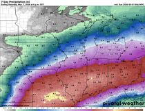
Timing of the forcing will be critical as to how much of eastern Iowa gets in on the storms. If it's faster most of the storms could end up occurring near or east of the Mississippi. A little slower movement gets more of eastern Iowa involved. Here's what models are indicating for rain potential through Friday night.
The GFS

The EURO

The WPC blend

Any residual showers or clouds move out early Saturday and we can expect a fine day to follow. Dewpoints will lower into the 50s during the afternoon. Even though temperatures should make it back into the low 80s the drop in humidity will make for an excellent May day.
Sunday won't be as nice thanks to an upper air disturbance that brings some periods of clouds and perhaps some showers. Best chances currently seem to be over the southern half of my area. Plenty of dry air should see to it that the showers are light and scattered where they fall. Highs will be noticeably cooler in the upper 60s to low 70s.
Next week looks active as we vacillate north and south of the mean storm track. Temperatures will be close to seasonal levels, perhaps a bit above. Precipitation should be near normal if not above with the close proximity of the storm track. Here's what the Climate Prediction Center indicates for temperatures and precipitation in the 6-10 day period.

Things don't change much in the 8-14 day outlook. Overall, slightly above normal temperatures and precipitation would work for me. Certainly nothing as extreme as what we've seen recently.

So there you have it, the end of a historical heat wave is in sight. Before it burns out, a muggy Friday is on the table which should end with some robust thunderstorms in spots.. That puts the capper on a remarkable week of May weather. Happy Friday and roll weather...TS


Comments