


BABY, IT'S COLD OUTSIDE
- Dec 4, 2025
- 5 min read
LIVE WEATHER BRIEFING 7:30 THURSDAY
Meteorologist Nick Stewart and I will conduct a Facebook live weather briefing at 7:30pm. Thursday. The topics of discussion will be the record cold Thursday, snow potential this weekend, and the long range weather pattern into Christmas. I'm sure we'll hit on some other weather angles, especially with your questions encouraged. Again, the briefing airs on the Terry Swails Facebook page. For a meteorological deep dive like no other, settle in with us Thursday evening. We promise to captivating and informative. We do weather right! Carry on...TS
An Arctic cold front speared the region late Wednesday, sending temperatures into a free fall. After highs that reached the low to mid 30s, lows Thursday morning could range from 13 below north to 4 below south. The GFS shows this. While this is very much on the table, it is contingent on winds becoming light by morning, which the GFS insists will happen.

As a result, temperatures on the GFS Thursday morning are shown to be nearly 40 degree colder than they were Wednesday afternoon. That's an eye-opener. Thanks to the light winds Thursday, wind chills won't be much less than actual temperatures, but nonetheless extremely cold for early December.

In fact, sub-zero lows are not that common this early in the season and has only happened 4 times or less since 2000 at Cedar Rapids and Dubuque. It has not occurred for 34 years at Moline. If Cedar Rapids reaches 10 below, it would be the earliest negative double-digit lows since 1891.
Not only that, record lows for the date are a good bet in many parts of the area. Here's where we need to be Thursday morning to set a new one.
RECORD LOWS FOR DECEMBER 4TH:
Burlington -3, 1991
Cedar Rapids -5, 2005
Dubuque -6, 1991
Moline -2, 1991
Thanks to the ample snow cover and continued cold air advection Thursday, temperatures are not expected to climb much during the day. Even with sunshine, highs on the EURO remain in the range of 6 north to 12 south.

It's even within the realm of possibility that record low high temperatures could be set. These are the two that are available that might be jeopardy.
RECORD LOW HIGH TEMPERATURES FOR DECEMBER 4TH
Dubuque 7, 1991
Moline 14, 1991
Of course, one of the reasons for the intensity of the cold is snow cover. It's like having a blanket of ice cubes 5–10 inches deep over the central Midwest. The 24-hour snowfall Saturday of 11 inches in Dubuque was the largest single day snowfall in Dubuque's history.

In Davenport, the 10.1 inches was the second-largest single day snow, eclipsed only by 11.9 inches November 25, 2018 (also coming on a Saturday following Thanksgiving.

Fortunately, the worst of the cold departs and the process starts late Thursday night. After midnight, the core of the cold shifts east and return flow causes temperatures to rise after midnight. Lows of zero to 5 below are expected before temperatures start to climb. Eventually, Friday afternoon highs reach 25 to 30. Life below zero is over for the time being.
GIVE THE GIFT OF MY 5 STAR AIRBNB IN GALENA

Holiday and winter specials are now in effect through March. Let us help you set up a personalized gift certificate that's sure to create a lifetime of memories! Santa Claus approved. Call or text Carolyn at 563-676-3320 for details and our very best pricing. https://www.littlewhitechurchgalena.com/
RUMORS OF WEEKEND SNOW
Saturday not much temperature change is expected before some clouds arrive later in the day. They are associated with a clipper that emerges out of Nebraska and tracks southeast into Missouri. Some key differences with the track exist, with the EURO further northeast than the GFS. The EURO is also better organized, with a more significant snow band. However, the clipper tracks, both systems appear to shear the energy out about the time it reaches my area, decreasing its ability to generate snow as it tracks further southeast. After a snowy midday run, the EURO backed off Wednesday evening, a negative trend as far as snowfall is concerned. We'll need a little more time to pinpoint what effects if any we see. However, as I indicated last night, the SW half of my area remains more favored for any worthwhile accumulations. Here's what the ensembles comprised of many members shows for a more averaged snowfall solution.
The EURO ensemble

The GFS ensemble

Here's the deterministic single runs of both models with accumulations that include higher than 10:1 snow ratios.
The EURO. It's earlier runs had 6 inches on Dubuque. So much for that in the latest one.

The GFS

Personally, I am leaning more towards the GFS, and I suspect it will be closer to the solution we see in later modeling Thursday. Another 24 hours should tell the real story.
After this, we are immersed in northwest flow, but the amplitude of the western ridge is diminished significantly early next week. This leaves the area open to potential clippers, but moisture is going to be minimal in NW flow and systems will move fast, limiting accumulations and confining them to small areas. Very difficult to pinpoint at this distance. At the very least, we should see some moderation in temperatures early next week.
Something I've noticed tonight, which is not yet a hard trend, is that the GFS takes a split polar vortex that digs towards the Great Lakes later in the week. Should that happen, a rather vast expanse of cold high pressure will ooze into the north central Midwest, producing 4–5 days of well below normal temperatures.

These are the temperature departures the GFS shows for December 12th

Just when you think we are really set up for some bitter cold weather, the vortex shifts east and a block sets up with troughs over the west and east with a ridge building into the Midwest.

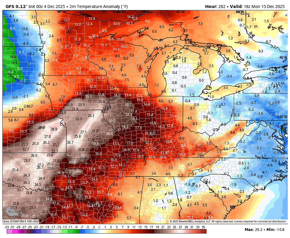
By December 15th, temperature departures have flipped to this. That would melt some snow!
Then it becomes a question of how long does the ridge hold. Considering the MJO is in phases 7 and 8, known to be cold phases in December, this is a curious development. One would think if the thaw comes, it would be relatively brief.

Whatever happens, the warming is 2 weeks away, and I thought it worth making a mention that a temperature fight may be on for mid-December. This is something Nick and I will discuss in our briefing Thursday on my Facebook page (Terry Swails) at 7:30. Hope to see you then. Stay warm and roll weather...TS
TSWAILS.COM expert weather consulting services (CLICK FOR MORE)

Private consulting
Legal forensic services as an expert witness
Public speaking engagements for groups or individuals
Post storm analysis
A private day-long weather school class
Specialized events forecasts
Severe weather seminars
Lectures and training
Climatological services
Meteorological workshops.


Comments