COOL IS THE NEW RULE....
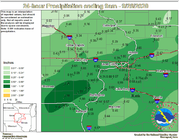
That front that came through the Midwest Sunday is re-aligning the jet and that is already leading us into a much cooler weather pattern that lasts into the coming weekend. The cool air also brought some much need rain to parts of the area. Unfortunately not everybody got in on the act. Here's some of the totals reported by the NWS in the Quad Cities. You can see it was the southeast half of the region that enjoyed the higher totals.

Northwest of a line from Omaha to Waterloo not much more than sprinkles were found.

Monday a pocket of cold air (what's known as an upper air low) was spinning southward generating enough instability for a few more showers. You can detect the energy centered over NC Iowa.

Late day temperatures were well below normal in the upper 50s to low 60s.

Tuesday the upper air low only slowly advances southeast so there should be enough instability again for another chance of spotty afternoon showers. They should be few and far between and I'm not looking for much out of the set-up with similar temperatures as Monday.
As the week wears on the trough is expected to dig and amplify even more allowing temperatures to cool further. Here's the 500mb trough and it should be sufficient to bring the coolest air of the season.

The air is dry too. These graphic shows available water vapor and you can readily see the dry air pouring into the Midwest on the backside of the trough.

If we can get a night with clear skies and light winds under the ridge axis the potential is there for a frost entering the weekend. However, models are not showing much agreement and there is lower than average confidence on this scenario. The GFS is the most aggressive Friday night showing lows well into the 30s.

Overall the pattern looks to remain cool the next 7 days before the trough begins to lift out bringing a warming trend next week. Here's the 5 day temperature departures through Saturday on the EURO.

Aside from the spotty shower chances Tuesday, additional opportunities for rain exist Thursday and again Saturday night/Sunday. The late weekend system seems to be the best organized but its track through eastern Iowa should mean the best chances for any meaningful rain would be in the NE half to third of my area. Still plenty of time to get a handle on that. Here's the rainfall forecasts through the coming weekend on the GFS and EURO. This includes 3 different opportunities.
The EURO

The GFS

At least for the next 6-7 days, cool is the new rule. Roll weather...TS


