INTENSE STORMS, FLOODING
- Jul 12, 2025
- 3 min read
Friday was another extremely active day of weather around the region. Nothing surprising considering the synoptic environment that was in place. Before things went off the rails, the Storm Prediction Center had already posted a level 3 enhanced risk of severe weather over much of the area.

Along with the threat of high winds and even a few tornadoes, came a significant flood and flash flood threat from several days of heavy rain events. My entire area was placed under a flood watch with numerous flash flood warnings issued Friday thanks to multiple rounds of storms with intense rainfall rates up to 3 inches per hour. This was something I had anticipated for numerous days.

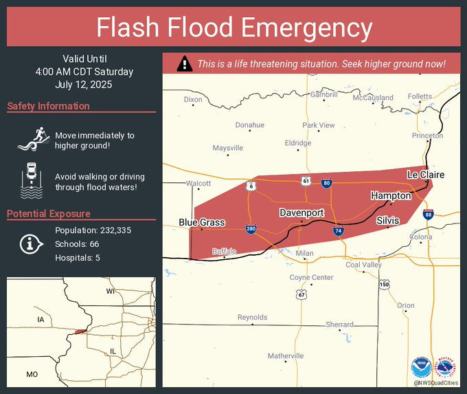
A PDS (particularly dangerous situation) flash flood warning was eventually issued for the Quad City Metro area, which was eventually upgraded to a flash flood emergency (a life-threatening situation). Emergency management and law enforcement reported major life-threatening flash flooding, especially in and near Davenport. Several business and residences were flooded, and numerous stranded cars.

Over the past 3 days, rainfall of 2–6 inches (locally 7) has been widespread across the region. Many local streams, creeks, and rivers have (or will) experience flooding, some significant.

Another facet of Friday's storms was damaging winds. A wicked squall line moved through the region during the late afternoon and evening. The bowing segment shown below, featured wind gusts of 50-90 mph as it roared across the area.

Here's another view of the line by way of the velocity mode, showing the strongest winds in pink and red producing damage from east of Galena back to the Quad Cities. By this time, winds of 85 mph had occurred in Cascade and most likely Bernard, Iowa

At my place in Dubuque, I estimate winds reached 80 mph. I snapped this image of the approaching shelf cloud.

I grabbed one more shot before the wind and torrential rain arrived. My west windows and siding were plastered with leaves following the siege. It was one of the more impressive storms I've witnessed in a number of years.

A lot of the strongest winds were found along the HWY 151 corridor from near Cedar Rapids to Dubuque. Another area of 70 mph gusts was noted around the Quad Cities. Below are NWS storm reports.

PRIME TIME TO VISIT TO MY 5 STAR GALENA AIRBNB
My 5-STAR AIRBNB just outside of Galena still has some openings this summer. All of our ratings are 5 star! We take pride in the amenities and the cleanliness. If you book now, we'll take off $200, and we can eliminate AIRBNB fees and additional costs that will save you big bucks. Other discounts apply. Call or text Carolyn at 563-676-3320 for our best deal of summer. See more at https://www.littlewhitechurchgalena.com/
TIME FOR A BREAK...
While some scattered showers may linger from time to time Saturday, they will be light and the threat for additional heavy rain is over. Temperatures the remainder of the weekend will range from 80 north to about 85 south. Sunday should be a fine day with the return of sunshine and much lower dew points in the 60s.
From the looks of things, little if any rain falls early next week, with the next chance of more significant rain due in about Wednesday. Until then, temperatures return to the 85 to 90 degree category Monday through Wednesday, with a significant jump in humidity. The EURO shows water vapor back over 2 inches Wednesday evening, which means the potential for heavy rain exists again the middle of next week. In fact, the EURO shows a wet pattern the next 2 weeks, with precipitation well above normal for the 14-day period ending July 26th.

After a wild and crazy stretch of weather, it's time for a well deserved break from storms and heavy rain. Have a terrific weekend and roll weather...TS


Comments