JUST A MATTER OF TIME
- terryswails1
- Sep 19, 2024
- 7 min read
Setting at my table writing this post, I just watched the sun slip over the horizon at 7:02pm. The shadows are heavy, and it's about time to turn on the lights. A little more than 2 months ago, I could make it to 8:45pm before the same process occurred. I also used to have to pull the shades down because the setting sun showered the room with so much light. Today, for the first time, I did not need to close the shades due to the lower angle of the sun in the southern sky. Until now, that was a necessity, with the setting sun showering the room with a wave of light. This was a benchmark moment. Despite the day's warmth, I fully absorbed the undisputable truth that summer is on its way out. It's just a short matter of time before these hazy, lazy days are just a sweet memory for months to come. It's the changing of the guard. To say the least, my heart felt a bit heavy. I guess it's the hard reality that just like summer, I'm well into the fall of my life. How time ticks.
On the plus side, it was another magnificent summer day around the Midwest. Above normal temperatures dominated the landscape from Canada to the Equator.

One of the areas where it was cold was Greenland. Winter is already established there with a heavy snowpack. The same cant be said for Eurasia, where little if any snow cover is currently indicated.

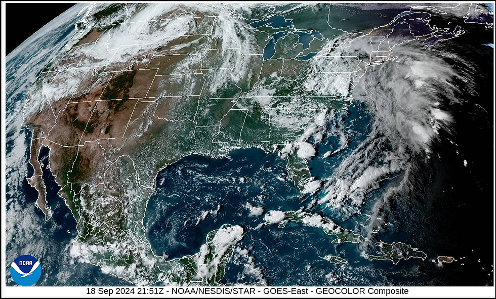
Looking at sea level pressure anomalies, there is a notable area of low pressure organizing over Montana and the northern Rockies. That's the area to watch for what appears to be the initiation of a pattern change that will break the cycle of what's been nearly a 3-week run of dry weather. It will also end a stretch of 80 degree highs that's pushing 2 weeks.

Notice the swirl of clouds associated with the lowering pressures to the northwest Tuesday night. That energy will swing a cool front towards the region Thursday night that should provide the forcing for at least scattered showers and storms.
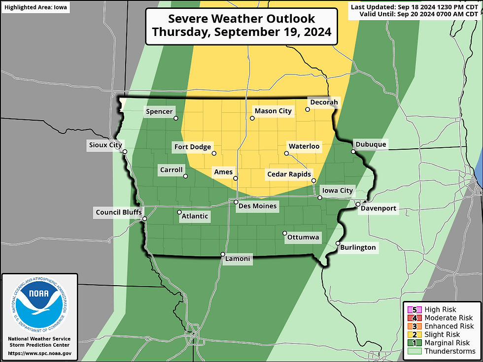
Unfortunately for my local area, the timing of the front is questionable for much in the way of concentrated rainfall. With the front arriving after midnight, much of the day's heating and instability will be wilting. That means storms which could be active in central Iowa will likely be weakening as they arrive here later in the overnight, especially with the forcing lifting more north than east. That said, SPC does have a slight risk outlook in place for severe storms in that area. What's left of that activity will be what bleeds into my counties late.
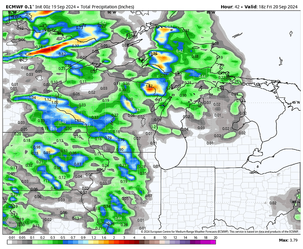
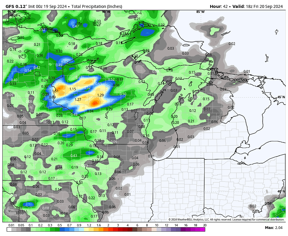
Here's what guidance is currently suggesting for rainfall Thursday night from this first disturbance.
The EURO
The GFS
The 3k NAM
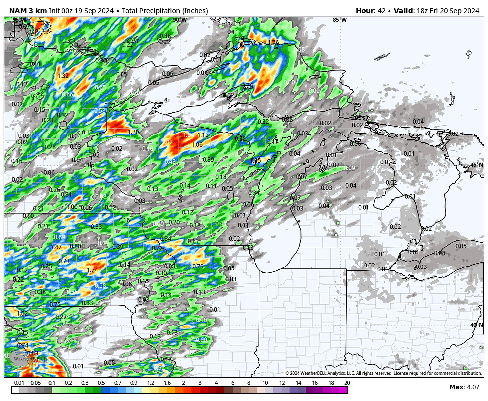
One thing seems a sure bet, and that's the fact Thursday will be a toasty day. With a pre-frontal draw well established, highs in the mid to upper 80s are expected to be widespread. A few spots in the south could touch 90.
It's back to warm, dry weather Friday and Saturday to begin the weekend. In general, highs will be in the low to mid 80s under partly sunny skies.
WETTER AND COOLER...
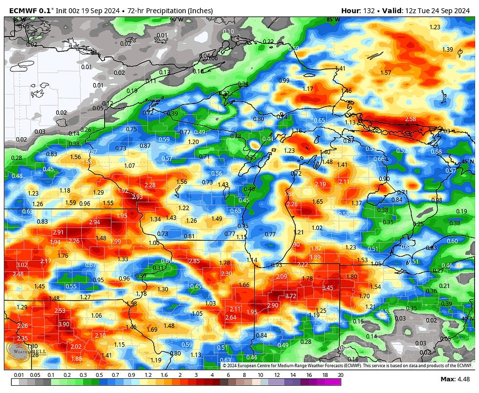
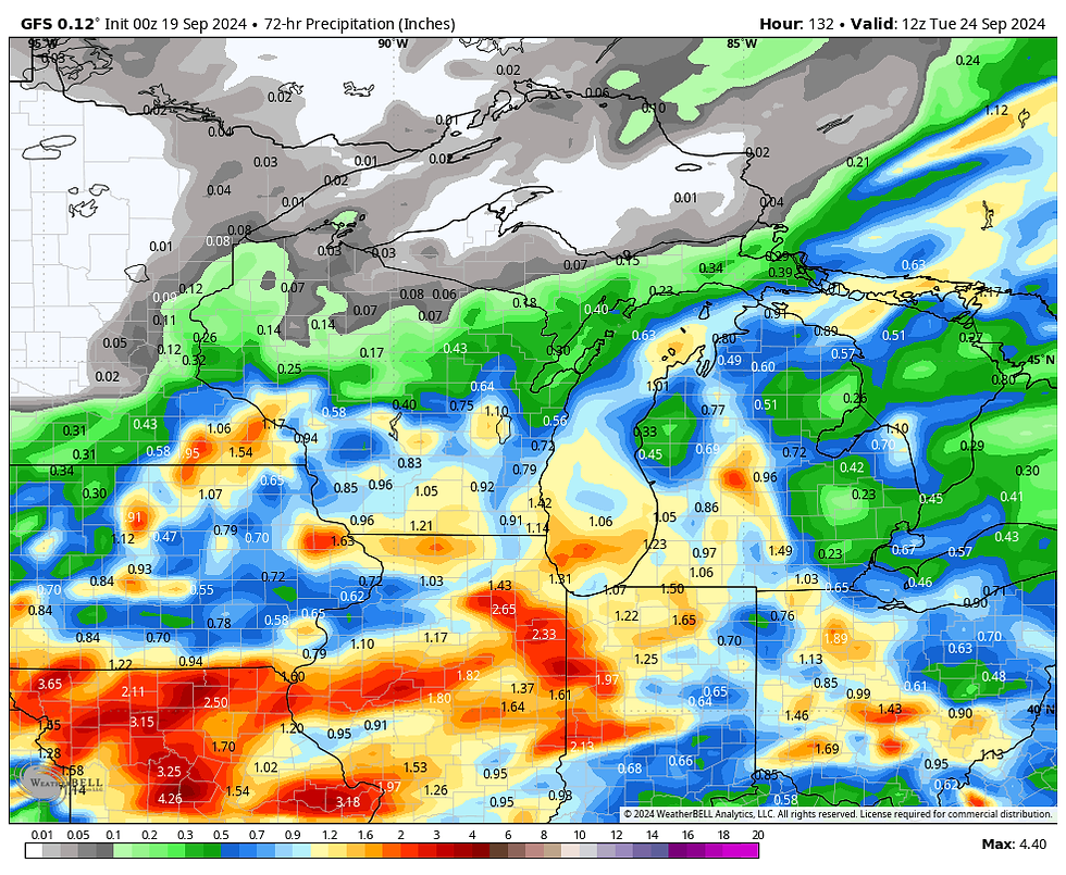
Saturday night and Sunday, trends have been for a faster ejection of an upper air low into the region that brings with much improved chances for beneficial rains. The system is centered around a cold core upper air low that only slowly cross the region. The yields a 36-48 hour window where scattered showers and storms are expected through Monday. Current indications are that some rain amounts could well exceed an inch. Take a look.
The EURO
The GFS
The 3k NAM

The addition of clouds and rain cooled air will finally bring our streak of 80 degree days to an end after a 12-day stretch. Here's what the EURO indicates for temperatures the next 10 days.

Long range, models have drastically different interpretations of how the long wave pattern evolves around the beginning of October. The EURO shows a powerful stacked area of low pressure over NW Iowa, October 3rd. That would bring an eye-opening brand of cold, unsettled weather.

The GFS is having none of that, bringing mild, dry, and very stable conditions to the Midwest.
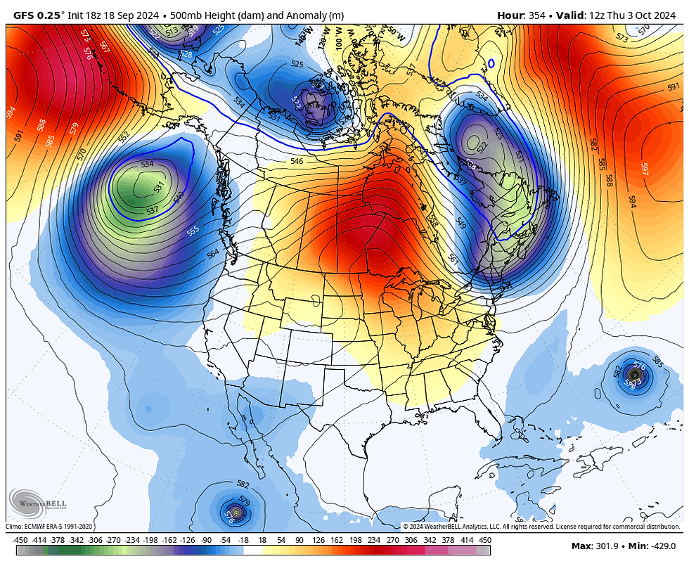
I can't even venture a guess as to how that all plays out. I do see signs that the MJO may enter phase 1 around that time, which is a harbinger of cooler weather. Something to watch and ponder in coming days.
With that, I leave you with another warm late summer day. Soak it up and roll weather...TS
PEOPLE LOVE IT. OUR AIRBNB IS A MOST LOVED GUEST FAVORITE!
ANOTHER 5-STAR REVIEW....thanks Myriam
AIRBNB has rated my renovated church in Galena A GUEST FAVORITE, A MOST LOVED home according to visitors. Check out some of our reviews and get in on the flexible deals we have available below.
Christa-Monument, Colorado
The Little White Church is amazing!!!! Pictures do not do it justice. I would absolutely recommend it to my friends and family. It is just so unique. Carolyn is an amazing host and super responsive. I would give our experience 6 out of 5 stars if I could.
Phillip-Queensland, Australia
Amazing and thoughtful renovation. Stayed in a piece of history. Great location and modern amenities. Would stay again!
Jill
The Little White Church is beautiful. The decorations are perfect, and it was redone with impeccable taste. Carolyn was a great host.
Brent
Such a gem. Relaxing in the countryside in a historic church that was beautifully decorated and recently renovated was exactly what we experienced. Everyone loved our stay, and we will be back!!!
Leigh
Beautiful and unique. We were all captivated by the adorable chapel turned AIRBNB
Jenny-Frisco, Texas
It was a magical place for our family to celebrate Christmas!
Kelly
What a gem! The Little White Church exceeded our expectations. It was the perfect spot to meet up with another couple to relax and explore nearby Galena. We enjoyed the beautiful great room with its fireplace and amazing views of the rolling countryside. (The photos simply can't do it justice). The charming church/home was quiet, well appointed and clean. And Carolyn was proactive with instructions and a terrific communicator. We will definitely be back!
John
Absolutely incredible! Loved the tranquility and the beautiful views. The decor was so inviting. AND the bell tower works!! Would 100% stay here again!
Tori-Cedar Falls
This place is so beautiful! Carolyn and Terry were so thoughtful and kind to let us have our wedding at the church. They even provided extra supplies in case we needed them. The private garden worked perfectly for our ceremony, and the backyard easily fit our reception needs. Not to mention, the balconies make perfect photo spots! My husband and I recommend the Little White Church and will be telling all our friends about it.
Mahesh-Buffalo Grove
Carolyn was a great host, very flexible! The place is super clean, spacious with a private backyard overlooking the fields and bluffs! We spent a lot of time on the deck. Great kitchen, clean bedrooms and baths. Highly recommend the place.
William
Great place. Great host. Will definitely book again and tell our friends.
Miriam
Carolyn and Terry's place is BEAUTIFUL! The Little White Church is a wonderful place, way more beautiful than the pictures. Everything is brand new and extremely clean. Staying at the church was a unique experience and I would love to come back soon. I strongly recommend the place if you are looking for a 5-star location!
Vanessa-Chicago
Carolyn was great! Absolutely beautiful place! I would not hesitate to go back. We spent Thanksgiving and the next night. Very well stocked and above and beyond with extras included. Thank you!
MAKE US AN OFFER...
What about pricing? Right now, we are able to offer you our best pricing ever. We have 3 nights for the price of 2 which, depending on the days, can save as much as $300-$400 dollars. If you book directly through us, you can also eliminate booking fees and taxes that the big chains charge. Cleaning fees are also drastically reduced. It all adds up to exceptional deals at a destination worth visiting. Let us assist in finding a time and price that works for you. Here's a link to some pictures. https://www.tswails.com/galena-airbnb
Carolyn and I will do all we can to make sure your stay is a memorable one. Please call or text Carolyn for more details and options and get a prime date while they are still available. Again, that's Carolyn at 563-676-3320. Or carolynswettstone@yahoo.com
Now that it's vacation season, there is no better place to visit than Galena and no better place to stay than my newly renovated AIRBNB, the Little White Church. We are located in the bluffs, just 5 miles from the 2nd largest tourism destination in Illinois. In fact, "Tourist Destination", rated Galena as the 2023 top place to visit in the entire Midwest.
Now is the best time to enjoy all there is to offer, and my 5-star AIRBNB is the perfect location to stay. Set in the rolling hills just outside of town, our completely renovated church is designed for you to unwind and relax.
Again, we are an AIRBNB Super host and can accommodate up to 8 guests. We've got cable, hi-speed WIFI, Sirius XM and a sparkling full kitchen. We are a home away from home and take great pride in cleanliness and comfort. All of our ratings have attained perfect 5-star status!
Hope to see you soon,
Terry and Carolyn
7 GREAT REASONS TO VISIT GALENA
1. It’s Steeped In History
2. It’s Home To One Of The Best Main Streets In America
3. The Restaurants Are Amazing
4. There’s A Lot To Do Outdoors
5. You Don’t Have To Travel To The Mountains To Go Skiing
6. It’s A Great Place To Spend The Fourth Of July
7. Did I Mention The Shopping?


Comments