


LET'S TAKE IT UP A NOTCH...
- Feb 26
- 4 min read
AN IMPORTANT UPDATE TO REPORT.

Thanks to 342 of you special people, I have reached 94 percent of the funding I need to get the sight through another year. I just need a little more help to get over the hump. If you use the site daily, find it informative, or make financial decisions based on it, please consider a donation. Any bit helps to keep it going in its no-pay format. Nick and I will work hard to bring you the reliable value you have come to expect the last 13 years. The future is up to you. Let's get it done. Thank you for your help!
WALKING OUT A CLIPPER, WELCOMING SOME WARMTH
A weak clipper winged its way southeast overnight, huffing and puffing in an attempt to dredge up some snow. Dry air and weak dynamics have overwhelmed its efforts and at the very best, a spots may have seen around an inch southwest of the Quad Cities. The most likely area for 1/2 to 1" accumulations by daybreak is along a line that runs from Grinnell, to Washington, Iowa on to Galesburg, Illinois. A brief period of freezing drizzle is also possible with the loss of saturation in the ice bearing layer aloft following any light snow. It's all long gone by daybreak. Areas from the Quad Cities northeast will remain dry. Here's what models are indicating for snow potential through 8:00am Thursday.
The HRRR

The national model blend of models

The GFS

The 3k NAM

The EURO

Due to the fast movement of the system, drier air will emerge again on the back end allowing decreasing cloudiness and seasonally mild air to prevail Thursday afternoon. Highs will range from the low 40s north to the mid to upper 40s south, perhaps 50 from HWY 34 south. Bye, bye snow for those of you who get a little.
NOW WE'RE TALKING...
Friday brings a big bite of spring with southerly winds and partial sunshine ahead of our next disturbance. Highs will likely hit the upper 50s north of HWY 30 to the mid to upper 60s elsewhere. The GFS indicates this.

Readings across the south should be 25 to 30 degrees above normal.

After that brief tease, a front settles south of the area Friday night bringing a healthy cool down for Saturday. Readings in the north may not climb out of the mid 20s, while from I-80 south, 35-40 should do it.

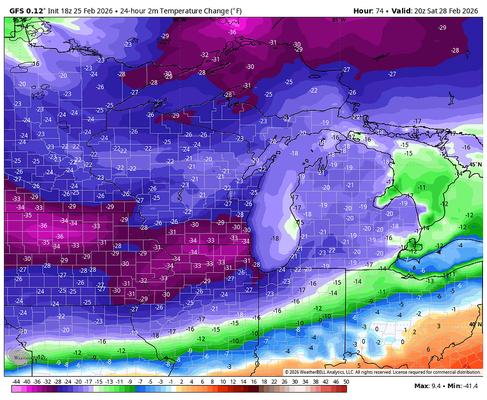
That means temperatures ping-pong from 30 above Friday, to nearly 35 below normal Saturday. Nothing like spring in the Midwest. Here's Saturday's departures.
With plenty of cold air in place and an upper level disturbance streaking along the baroclinic boundary in place, a period of light snow is possible Saturday north of HWY 30th, especially closer to HWY 20. The heavier amounts should fall just north of my area, however a dusting to perhaps an inch is possible near HWY 20. Here's what models are depicting Saturday afternoon.
The EURO

The GFS

The next system fast on the heels of Saturday, takes aim on some part of the Midwest later Sunday and Sunday night. Last night I discussed how I feared the GFS was way too wet and too far north with the system. 24 hours ago it showed much of the area with 8/10ths to an inch of liquid precipitation. Take a look.

It showed this for snowfall, but I wouldn't even show it since I felt the amounts were so high and unlikely.

The bottom line is that I was very skeptical of the GFS (and even the EURO), getting deep moisture and proper dynamics this far north to produce much more than light precipitation. Now look at what the GFS shows and compare it to last night. What a joke. Dubuque went for 1.06" of liquid and 10.2 inches of snow to nothing...in 24 hours. Well, at least I saw it coming before the models. Below the new trends.
Current GFS liquid precipitation

The current GFS snowfall.

Here's the latest EURO precipitation and snowfall.
Precipitation

Snowfall

Today, the EURO is slightly further north than the GFS with precipitation, but amounts are generally 1/3 of an inch or less. It also has 1-3" of snow for much of the region Sunday night. Actually, that's fairly consistent with what it showed last night. Due to that I feel it has the right idea. That said, we could still see some minor fluctuations in future runs.
I don't think there's much more light I can shed on that situation for now. I would expect models would tighten up considerably in their solutions over the next 24-48 hours. Currently, it's another low confidence forecast.
What I do feel good about is a big warm-up in the week 2 period. A ridge blossoms over the east and the door is open to an extended period of well above normal temperatures. Here's a look at the meteograms of the EURO and GFS. Both are very consistent that some toasty readings enter the picture around March 5th.
The EURO

The GFS

These are the 5 day temperature departures on the EURO March 5th through the 10th.

Something else I am heightened by is the precipitation potential in the coming two weeks. Both the EURO and the GFS now indicate well above normal amounts. We need it and if it happens it could help a whole lot of people in the heartland of the nation. Here's the 15-day departures ending March 11th.
The EURO

The GFS

There is certainly a lot of things cooking going into early March. More good than bad. A nice way to end this post. Roll weather...TS ON A MORE SERIOUS NOTE, IF I CAN'T MEET MY FINANCIAL GOALS, THIS WILL BE THE LAST YEAR OF THE SITE. IF YOU LIKE THE CONTENT, THE FUTURE IS UP TO YOU. T.S. 94% to my goal.


Comments