SLIP SLIDING AWAY...
- Aug 22, 2022
- 3 min read
We are headed into the last week of August and the month (along with summer) is slip sliding away. A couple weeks ago I posted that I thought we had seen the worst of this years heat and humidity and that has proven to be the case. So far high temperatures for the month are running below normal and the last 7 days have had a fall feel with significantly below normal values. Here's the month's highs as a whole.

These are the highs the past week.

The coming week brings more of the same with 7 day temperature departures ending Sunday near to slightly below normal

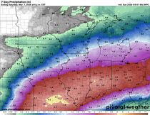
Rainfall during the period should be a bit below normal. The first chance comes Wednesday night/Thursday but the majority is likely to fall in the period Saturday night through Monday. Here are the 7 day rainfall departures on the EURO.

Prior to that the next couple of days promise to be nice and dry. Highs Tuesday will be near 80 with low to mid 80s on the table Wednesday. Wednesday night and Thursday a short wave dips in on NW flow providing the lift for scattered showers and a few thunderstorms. Guidance is mixed on the location of the best forcing but In general its a progressive system and amounts should come in on the light side with the NW half of the area favored for the higher amounts. Here's what models are suggesting for totals.
The National Model Blend (NBM)

The GFS

The EURO

Even after the passage of the disturbance and its associated cool front, temperatures really don't fall off much as highs Thursday through Friday remain in the upper 70s north to the low 80s south. That's close to the norms for late August.
So, following another pleasant day Friday, winds turn to the south by the weekend initiating warm advection and renewed chances for showers and thunderstorms Saturday through Monday. From the standpoint of dynamics, this system has far more potential as a rain producer than it's predecessor. Water vapor increases to more than 1.50 inches and the forcing is prolonged over a 48-60 hour period. The biggest question is where the boundary (with its most prolific forcing) sets up for the longest period of time. Significant rains are likely near that baroclinic boundary but we are still too far out to determine the area most at risk. Mesoscale details critical to the outcome won't be known for several days but current trends indicate some part of the central Midwest is in line for some generous rains...that could include much of my area. The national model blend shows this for rainfall totals.

Temperatures during this period will be tricky due to the amount of clouds and rainfall that eventually develops. The conservative approach yields highs in the low to mid 80s but if the boundary ends up further northwest that could mean highs close to 90, especially in the southeast half of the region, particularly southeast of the Quad Cities.
Whatever happens, Tuesday is going to be another outstanding day. Aside from some patchy morning fog, the remainder of the day looks sunny and comfortable with very little wind. It should be a near perfect late summer day. One that we don't want to take for granted with September knocking on the door!
Before I go I do want to thank Nick Stewart (the Rocketman) for stepping in as my guest blogger last week while I worked on another major project. He and his dog Stormy came through in a big way. I thank Nick and the ever reliable Rebecca Kopelman (RK) for upholding the standards I've set forth for the site. They are great young meteorologists. Even better, they are exceptional people who I am fortunate to call friends. Have a great day and roll weather...TS


Comments