


SPOOKTACULAR, BUT THE CLOCK IS TICKING...
- terryswails1
- Oct 28, 2022
- 4 min read

Here we are folks, closing in on November. Like it or not, the shorter days and lower sun angle are taking a toll. It may not be showing up much in our weather the next week but winter is rustling and I think by mid-November it may be knocking on the door.
Why do I say this when there is little concrete evidence to show it in traditional modeling? Because I believe in teleconnections. The planet is 70 percent water and what goes on within our vast oceans regarding water temperature and vertical velocity, has proven to present clues to trends before the models shown on this site are ever in the game. We may not know the specific details, but by observing ocean temperatures and energy transfer in specific areas of the Pacific or Atlantic, we can utilize analogs to reveal temperature and precipitation patterns for certain times of the year.
One teleconnection that's very valuable in the winter months is based on the location of convective energy in the Indian Ocean. This is what's know as the Madden Julien Oscillation (MJO). When we see the makings of a convective wave develop in the western Indian Ocean we know we are in phase 1. From there we track the wave and monitor its position and expected progression through the Indian Ocean into the western Pacific. Each phase (highlighted in red below) is correlated to North America temperature and precipitation patterns for each month. It's also interesting to note that any phase (be it 1 through 8) produces different results in different months.

Below you can see the temperature and precipitation patterns the various phases produce in the fall and winter.

That's tough to read so here's a tighter version where you can see an example of what phase 8 temperature and precipitation analogs look like in September, October, and November. Similar phase analogs are available for every month of the year.

So currently we are in phase 6 which is a mild phase in October (November as well). But what I'm seeing longer term is the majority of MJO forecasts cycling the current convective wave into phase 7 in November. That supports below normal temperatures over all of the Midwest. The dotted lines in black show the MJO progression day by day since October 16th. The red lines signify the EURO MJO forecast for the rest of October and the blue lines where it's projected to go in November. Note how phase 7 correlates to colder temperatures and where readings may be headed in November.

Now lets take a look at the Western Pacific oscillation (WPO) and the EPO (eastern Pacific oscillation). The Pacific is a massive ocean and since our weather often originates from there due to the Earth's rotation, events out that way are often dictated by what phase the MJO is in. These are all interrelated pieces of the bigger puzzle. I really keep and eye in the EPO in winter. We get winter's worst when it is in the negative phase which forces a ridge off the west coast of the United States. That in turn allows the jet to buckle, further opening the door for polar air to enter the central U.S.

The EPO is projected to go solidly negative on the EURO by November 11th. So again, another driver/teleconnection that suggests colder weather on the way.
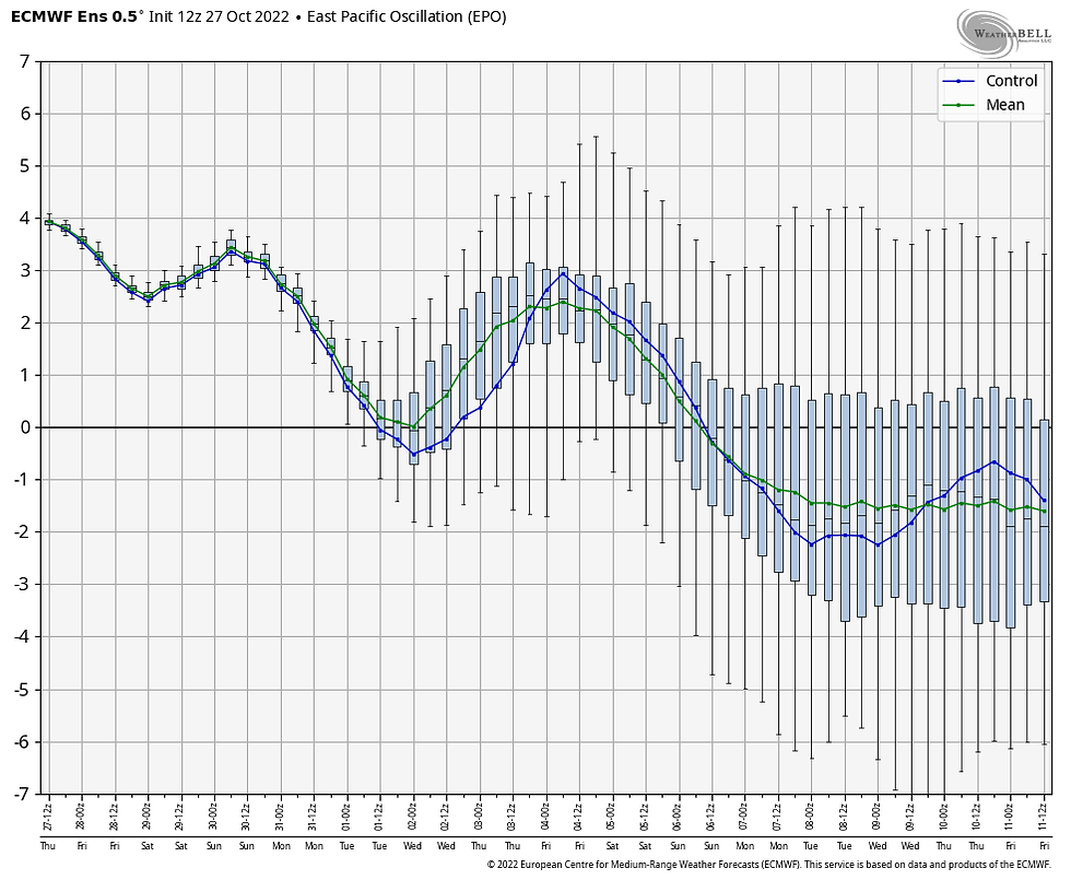
The WPO is also in the same camp

Another teleconnection is one based on the JMA (produced by the Japanese Meteorological Association). It shows the MJO well into 7 and about to enter phase 8 in roughly a week.

In sync with the MJO, the JMA's 500mb flow is indicating a trough building over the Great Lakes in the week 3 and 4 period. That implies the JMA also sees a way for colder air to get into the pattern by mid to late November.

By the way, if we do enter into phase 8 later in November or December (nothing more than speculation at this point), then it's game on for winter. Not only is that a cold phase its a wet one. A set-up that would be conducive for snow in the Midwest.

Anyway, as a forecaster I start my long range outlooks with the MJO. If I see it's going into a cold phase and other teleconnections are supporting it, I have to give it respect despite the fact week 2 temperature departures on the EURO show a paint bomb for the 7 day period ending November 11th.

No doubt we will see a warm period the next 6-10 days as we work our way out of the warmth of phase 6. But if indeed we get into phase 7 as it appears, that signals changes are underway that could very well lead to our first solid taste of the winter ahead. Of course there is no such thing as a sure bet in weather, especially out 10-14 days, so I could be wrong. However, if I didn't think there was a strong legitimate trend for colder weather longer term I wouldn't be laying it out for your consumption. You are seeing my inner geek. Weather is just so dang fascinating to me!
SPOOKTACULAR HALLOWEEN WEATHER...
So here we are heading into the big Halloween weekend and it seems we are on track for some spooktacular weather. We begin with a gradual warming trend with highs near 60 Friday. Saturday 60-65 is possible. Sunday a southern stream system will spread some clouds into my southeast counties with a small chance of a few showers or sprinkles SE of the Quad Cities. The clouds could hold temperatures a few degrees cooler, especially in the SE but most spots should at least see 60, warmest NW where more sunshine is expected.
Halloween itself should not be frightful for trick or treaters with highs in the low to mid 60s and a few wisps of cauldron clouds. Far better than the ghoulish year of 2019 when local ghosts and goblins sloshed through 2-5 inches of snow cover and temperatures in the upper 20s. The high that year in Dubuque was only 31 with a 5 inch snow depth. A howling good day for October 31st!
After Halloween we get even warmer and the potential is there for highs in the 70s by mid and late week. Enjoy it, this is probably the last hoorah for weather like that! Happy weekend and roll weather...TS


Comments