


THE POLAR PLUNGE...
- Dec 11, 2024
- 3 min read
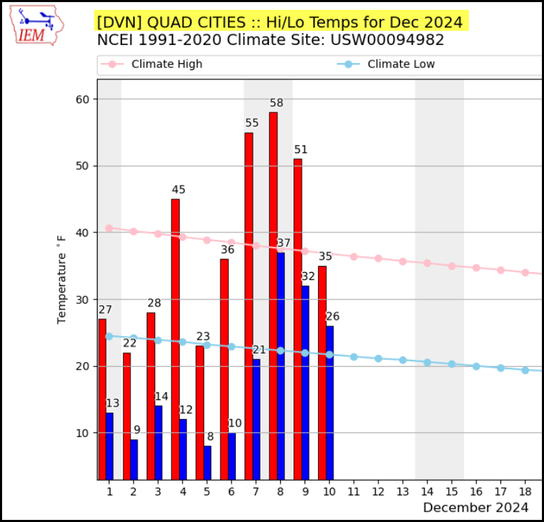
After a rather frigid start to December, a thaw of significant proportions took highs from the low 20s to the upper 50s in the blink of an eye. Since Sunday, the mild conditions have peaked and temperatures have been trending down, first gradually and now incrementally. Thanks to a potent but fast moving surge of Arctic air, readings will begin to slip Wednesday and free-fall Wednesday night. Here's a history of temperatures so far this month in the Quad Cities.
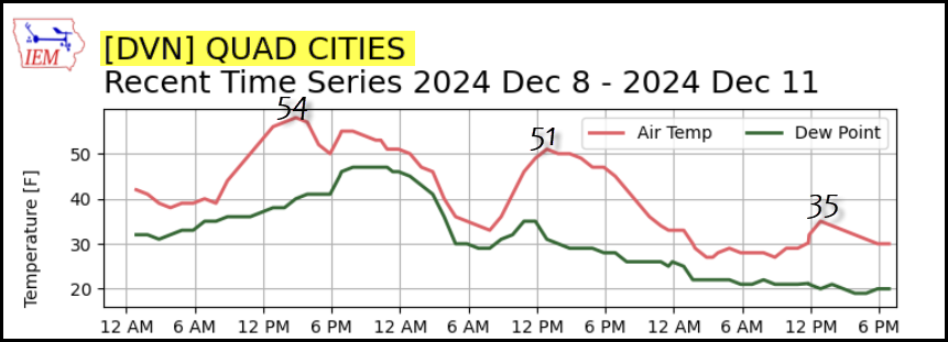
Another perspective of the temperature downfall that only intensifies the next 24 hours.
At the surface Wednesday, the packed isobars indicate rising NW winds that will drive the Arctic air mass into the Midwest.

By late morning and into the afternoon, gusts of 35 to 40 mph are expected.

The HRRR indicates 850 temperatures diving to -23 in Dubuque, which is near the SPC historical low for a sounding at 5,000 ft December 12th.

Lows Thursday morning will be in the single digits, with the HRRR indicating zero in Dubuque.

Below zero wind chills will be common to start the day Thursday, with some in the north close to 20 below. Ouch!

Afternoon highs should make it back into the low to mid-teens later Thursday as the crux of the cold passes to the northeast.
A final issue to address is the snow shower potential. The extremely cold air aloft is bound to generate steep lapse rates necessary for snow showers/squalls. These are most likely from daybreak into afternoon. They tend to be rather hit-and-miss in coverage, traveling in bands from NW to SE. Snow rates can be quite intense but for only brief periods of time. Therefore, most places should see little more than a dusting. However, some of the stronger banded squalls could end up capable of producing isolated pockets of 1/2 to 1" accumulations.
After a frigid but dry Wednesday night, a band of light warm advection snow is shown on most models streaking rapidly across my southern counties Thursday afternoon. Due to the cold air, any snow that develops will produce high snow ratios and fluff up nicely. However, water equivalent is projected to be .05 or less, which should keep any accumulations in the south to .5 to 1.0 inch. More of a nuisance than anything, but certainly enough to cause slick spots if current trends hold. Most of the snow should fall from I-80 south. Here's what models are suggesting for snow.
The EURO

The GFS

The 10K GEM

The 3k NAM

HOLIDAY SALE AT OUR GALENA AIRBNB (CLICK BANNER)
40% off a weekend or weekday stay in December-February. Call or text Carolyn now at 563 676 3320

A STRONGER SYSTEM TO START THE WEEKEND
Friday, the Arctic air that was in place Thursday beats a hasty retreat as strong warm air advection develops ahead of a wave crossing the Plains. The big question remains, how much cold air remains and will wintry precipitation develop. The latest guidance indicates respectable moisture but a slight shift north on the track. That implies the area north of HWY 30 may be glanced by a short period of snow, freezing rain, or even sleet before a transition to good old rain. The south is likely to avoid those issues if trends hold with just rain indicted.
As it stands snow, precipitation moves north across the area later Friday evening before the bulk of it departs from south to north Saturday midday. The EURO shows the mixed precipitation late Saturday night in the north, with rain south.

Whatever happens initially, it should not be a problem even in the north Saturday as temperatures quickly go above freezing and into the 30s. Again, the window for travel concerns would mainly be north of HWY 30 and especially focused on the area of HWY 20 north Friday night. It's just too early with too much uncertainty to get cute with precipitation types and accumulations. Even if there was any snow or ice, I doubt accumulations would amount to much. However, with ice, a little goes a long way. Stand by!
As for precipitation, that is something we could really use after another 3 plus weeks of dry weather. Here's what the EURO and GFS indicate for precipitation totals Friday night and Saturday. Just how much of it comes in a wintry form? Sadly, little if any falls as snow and what a shame as colder temperatures would have produced a nice 6-12" swath of snow.
The EURO

The GFS

Get ready for a quick return to the deep freeze tonight and Thursday. At least for 48 hours, it's back to winter. Have an outstanding day and roll weather...TS


I Was Eagerly Looking For Content Like This, Right To The Point And Detailed As Well Accordingly Depending Upon The Matter/Topic. You Have Managed This Greatly For Sure 짱구 도메인 주소
This article was written by a real thinking writer.I agree many of the with the solid points made by the writer. 888카지노
Nice to be visiting your blog again, it has been months for me. Well this article that i've been waited for so long. I need this article to complete my assignment in the college, and it has same topic with your article. Thanks, great share: 띵벳
Khi lựa chọn một nền tảng giải trí trực tuyến, tôi thường quan tâm đến mức độ mượt mà trong quá trình thao tác vì điều này ảnh hưởng trực tiếp đến trải nghiệm tổng thể. Những hệ thống thiếu tối ưu thường gây ra tình trạng giật hoặc chậm khi chuyển đổi giữa các nội dung khác nhau. Trong quá trình sử dụng https://luck8.gay/ tôi nhận thấy các danh mục được chuyển đổi khá nhanh và không xuất hiện độ trễ rõ rệt. Điều này giúp tôi duy trì được nhịp sử dụng ổn định mà không bị gián đoạn giữa chừng. Với tôi, yếu tố mượt mà đóng vai trò quan trọng trong việc giữ trải nghiệm liền…
Tính cập nhật là yếu tố quan trọng giúp một nền tảng trực tuyến duy trì sức hút trong thời gian dài. Những hệ thống ít thay đổi thường khiến trải nghiệm trở nên lặp lại sau một thời gian sử dụng. Với Luck8, các nội dung và sự kiện được bổ sung thường xuyên, giúp tạo cảm giác mới mẻ trong quá trình truy cập. Điều này giúp người dùng không bị nhàm chán khi quay lại nhiều lần. Việc duy trì tần suất cập nhật ổn định cho thấy hệ thống có định hướng phát triển lâu dài. Khi nội dung liên tục được làm mới, trải nghiệm tổng thể sẽ trở nên linh hoạt và phù hợp…