THE WINDS OF CHANGE...
- May 14, 2022
- 3 min read
Change is a way of life, as it is in weather. The atmosphere is fluid, dynamic, and constantly in a state of flux. While Friday was still warm, it was far less humid indicating a pattern change is underway that moves us from summer back to more typical spring conditions. Here's Friday afternoon's temperatures, once again in the low 90s along the spine of the Mississippi. Moline set another record high with a reading of 94. The NWS in Davenport measured 93. Much cooler temperatures were noted to the west in central Iowa.

Notice temperatures in NC Iowa were down 20 degrees from 24 hours earlier.

Of even more significance are the dew points. A dry line associated with the cold front had lowered dew points into the low to mid 40s Thursday at mid-afternoon.

As you can see, those readings are as much as 30 degrees lower than 24 hours earlier.

What is all means is this exceptional stretch of heat which has produced 4 consecutive days in the 90s in the Quad Cities (and many other parts of the region) is all said and done. What a run it was with temperatures at the NWS office in Davenport as high as 97 Thursday.

For perspective, this graphic shows the frequency of having such a warm temperature at 2 PM in any given month. The May frequency is just 1.9%, which equates to having about two days in the 90s for every three years worth of Mays. To have 4 consecutive 90 degree days as Davenport just did is a really big deal, statistically something that's extremely rare and difficult to accomplish, especially before May 15th.

After this span of very warm dry weather it would have been nice to end it in all areas with a nice rain but the dry line was advancing at a rate that kept the forcing east of the Mississippi in my Illinois counties. For that reason the heat wave ended with a whimper west of the Quad Cities, and a bang to the east where storms quickly blew up after 4:00pm. Several thunderstorm warnings were issued and a confirmed tornado/landspout was reported near Monmouth. Some half inch hail and 60mph winds were also noted. Torrential downpours occurred in the stronger storms east of the river. Radar around 5:30 looked like this as thunderstorms lining up along the front.

THE WEEKEND
Our weekend gets off to a great start Saturday. Sunshine will combine with very dry air to produce a bright, shiny, and warm day. Highs will likely reach the low to mid 80s but dew points should fall into the 30s in the afternoon. That means comfortable conditions with no humidity to speak of. Here's what the HRRR shows for dew points.

That translates to relative humidity values at mid-day under 20 percent. A huge change from Tuesday and Wednesday.

Sunday a wave crosses the Midwest with just enough moisture to generate clouds and some showers. With limited moisture they look light with amounts 1/4 inch or less. Clouds and scattered showers though could hold highs to the low to mid 60s. Certainly, much cooler than what we'll see Saturday. Here's the 24 hour temperature change the GFS is suggesting on the order of 20 degrees from Saturday to Sunday. Make your outdoor plans accordingly.

Next week looks a bit unsettled to start with some shower chances Tuesday and Wednesday before warmer air arrives to close out the week. You can see the trend of cooler readings to start the week and warmer ones to end it in the meteograms of the EURO and GFS.
The EURO

The GFS

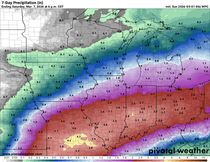
I guess the big take away of the forecast is that after a warm but humidity free day Saturday, cooler readings more typical of mid May arrive Sunday and remain in place through the middle of next week. Then another warm-up arrives to close out Thursday and Friday. Precipitation departures over that 7 day period are in the 1/2 to 1 inch range over my area indicating a drier than average week.

That's all for now. Have a fantastic weekend and enjoy Saturday, it looks to be a 5 star day! Roll weather...TS


Comments