WHAT COMES AROUND...
- May 16, 2022
- 3 min read
Just when you think we've turned the tide and buried the chill that's plagued us most of spring, another curve ball is coming our way. This is what the GFS loading pattern for the PNA (Pacific North America) teleconnection looks like over the coming 10 days. Notice that great big spike towards next weekend. That is what's known as a strongly positive PNA.

Why do we care. Well, a positive PNA of that strength means a significant west coast ridge with a downstream trough over the eastern U.S. The graphic below depicts the resulting 500mb anomalies on the left and surface temperatures on the right.

The end result is an upper air structure (jet stream position) that looks like this. The strong NW flow opens the door to polar air masses which can still have a noticeable kick, even in mid to late May.

The operational models are definitely seeing the trend as evidenced by the deep trough the EURO carves out next Saturday. That trough depicts heights that are about 3 standard deviations below normal.

The GFS is in strong agreement.

Get a load of the cold air that's being delivering to the northern Plains and upper Midwest next weekend.

The air is so cold it sets up a significant late season snow potential in North Dakota, at least according to the EURO.

The positive PNA configuration appears to lock in for a awhile and that means temperatures starting next weekend and beyond (the week 2 period), are looking well below normal. These are the temperature departures for the period May 24th-30th. Much of the nation is well below normal with the chill focused directly on the central Midwest.

The worst of the chill is shown around May 25th when highs are barely above 50 on the GFS.

Readings like that are a solid 20-25 degrees below normal. Good grief Charlie Brown! I'm done with that.

BEFORE THE COOL-DOWN...
In the short term, the week starts nice with sunshine and comfortable temperatures Monday. Highs should reach the range of 72 to 77 and with light winds it's going to be a fabulous day.
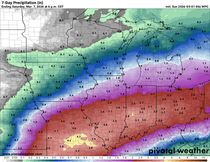
Tuesday and Wednesday, a NW flow disturbance will clip the area. It is likely the best forcing remains over the SW half of the area and that would mean the best chances for meaningful rain would be found there. Here's what models are showing late Tuesday through Wednesday. The EURO seems too wet in the north and I question its solution.
The EURO

The GFS, probably too heavy, especially north of I-80

The 3k NAM (more to my liking)

The 12K NAM, in line with the 3K NAM

Depending on cloud cover and where any rain sets up, temperatures should range from the upper 60s to mid 70s both days. Close to normal.
Thursday warmer more humid air invades before the big trough and its cold air arrives later Friday. Temperatures should reach the 80s Thursday but will likely turn cooler Friday assuming the front sweeps through as early as the EURO indicates. While a few showers and storms are possible with the cold front, the early arrival is poor for much in the way of rain and little is currently depicted. Pretty early to make that call.
Like it or not, the weather pattern looks unsettled but at least seasonal in the coming week, the trend for cooler below normal conditions is lurking for next weekend and beyond. Enjoy your Monday and roll weather...TS


Comments