
A CHANGE OF PLANS, MAKE THAT TRACK...
Before we get into the next storm, just a little recap of what went down in many parts of my area with the last storm. I'll start you off with a couple shots from my meteorologist Rebecca Kopelman, my weekend contributor here on TSwails. She is better known to you and especially me as RK. Look at the happy face outside her place in Marion, Iowa. Snow halfway to her knees!. So exciting for a girl from Florida! This is RK's makeshift measuring stick which came in just short of

THE NEXT STORM UP...
A compact but intense band of snow shot through the northwest 2/3rd of my area Tuesday producing heavy snow that in a few spots was in the 9-12 range. Intense snowfall rates of more than 2" per hour were observed in convective bands that produced thundersnow and whiteout conditions. Here's some preliminary snowfall totals from the Iowa mesonet. The heaviest snow, 5 to 12" was roughly north of a line that ran from Ottumwa to the Quad Cities and on to Sterling, Illinois. Totals

WINTER STORM WITH ALL THE FIXINGS...
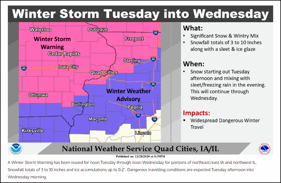
A complex winter storm will bring the kitchen sink to my area later Tuesday and Tuesday night. Precipitation starts as snow and then transitions to sleet and freezing rain in the central and south. South of HWY 34 it even warms enough for a period of rain and drizzle where the freezing line inches further north. At the time of this post these are the warnings and advisories in effect from the NWS. A large portion of my area (save for the far southeast) is under winter storm w

STRONG WINTER STORM ARRIVES TUESDAY....
A powerful winter storm will be moving into the Midwest on Tuesday. With it there will be accumulations of ice and snow. There is still uncertainty in terms of how much snow/ice falls and where. In the next 24 hours we will really have a better handle on the situation, but there will likely be headaches along the way. The National Weather Service has already started to post Winter Storm Watches as of Sunday evening: The Watches will surely be extended east. So, first things f

SNOW ON SUNDAY, MORE COMING THIS WEEK...
Saturday was a nice day. Ya know, relative to the two days we spent with sub-zero wind chills and sub-freezing temperatures. There was sunshine and a lot of the snow outside melted away. Well, a little clipper is on track that will bring the chance for some light snow to the ground on Sunday. First, temperatures will climb into the 20s and 30s. The clipper will move in during the afternoon hours. Due to temperatures being above freezing in southeast Iowa into Illinois, there