THE FIGHT IS ON....
- terryswails1
- Mar 9, 2018
- 2 min read
The next weather maker this weekend is proving to be a challenge for weather models and forecasters alike. The issue is tied to phasing between the 2 branches of the jet (the northern and southern streams). This interaction has a significant impact on where the disturbance tracks as well as its intensity and impacts on sensible weather.
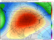
You can see the difference in the 500mb jet stream forecasts of the GFS and EURO. The EURO has a broad tough without concentrated energy.

The GFS has a similar mean trough but is much more energized with a closed low over eastern NW Missouri and additional energy in NE Arkansas.

The EURO solution implies a much weaker system and that's reflected in its precipitation forecast Saturday night and Sunday. Here it is.

Look at the difference in total precipitation between the EURO and the GFS below.

There's also the potential some of the precipitation could come in the form of snow. The EURO doesn't show much with its much lighter QPF.

The GFS paints a far snowier picture for eastern Iowa with some 8" amounts.

As a forecaster, what do you do? First you consider the models. 2 days out I'm already leaning to the EURO with its better physics. But, that's not the only reason. I think the mean trough and fast flow is likely to shear the energy making it difficult for it to amplify as much as the GFS shows. I also think the blocking in Canada is strong enough that the more southwestern track of the EURO will verify. Last but not least, dry air and easterly winds will make it tough for precipitation to advance much beyond central Iowa. In other words I'm not buying what the EURO is showing.
Could I be wrong? You betcha. It's happened many times before but hopefully you learn from your mistakes. I'll be very interested to see what the new EURO shows later tonight. Hopefully I'm on the right track. Otherwise, the GFS scores a rare but big win. Roll weather...TS
P.S. I'm still liking a big warm-up that should include at least 60s around March 16th...


Comments