DRYING OUT, STAYING HOT....
- rebeccakopelman
- Jul 1, 2018
- 2 min read
We're drying out in the Upper Midwest after a soggy June. As I discussed in my last post, there are some areas that have had a lot of rain this month and others that didn't and are experiencing a drought. However, the areas that have picked up a lot of rain picked up even more rain Saturday night.

Very heavy rain fell around the Des Moines area - coming in a short period of time. The ground was already very saturated and the additional rain led to flash flooding.
Rivers and creeks rose quickly and exacerbated the flooding. Fourmile Creek, in east Des Moines, rose high and fast up from around four feet to over 17 feet.

That was above the record of 16.1 ft (set in 2010) by over a foot. The water is receding, but it will take some time. It drying out some to start the month of July, but it is going to be hot. Every time heat and humidity builds back in, there will likely be some showers and thunderstorms around. Here's a look at the next week of projected precipitation.

Zoomed in my local area....

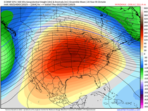
The weather will be driven by a strong ridge over the central United States this week. That will lead to hot and humid conditions and periodic storm chances. Some strong storms will be possible this week, but the tornado risk will overall be low. And this year has been a low for tornadoes, with just 571 in the United States - the lowest in ten years.

A below average tornado season is nice to see, but there is still time left in the summer and fall for additional tornadoes.
In general, though, we can use some dry time around here.. and a break from the humidity. The humidity will be high once again this week and heat index values will once again be near and above 100 degrees Tuesday through Thursday.
If you're traveling or staying in the area, stay cool during the 4th!
RK


Comments