


THE HOME STRETCH...
- Dec 12, 2025
- 5 min read
Thursday was a tale of dry air as far as my area was concerned. Models really struggled to define its southern extent and the impact it would have on snow. In the end, it was further southwest than expected by at least 30 miles. That made a difference, with most of the accumulations, (which were generally in the 1-3 inch range) ending up just SW of the Quad Cities. The largest totals, in spots, could have hit 4 inches in the blue-green shading below from near Williamsburg to Washington in Iowa on southeast to Oquawka and Avon in Illinois.

These are some of the preliminary snow reports through the evening by way of the Iowa Mesonet.

Notice how roads Thursday evening were snow covered southwest of the Quad Cities, but in normal driving conditions to the northeast where little if any snow fell. That's your cut-off to the dry air.

GIVE THE GIFT OF MY 5 STAR AIRBNB IN GALENA

Holiday and winter specials are now in effect through March. Let us help you set up a personalized gift certificate that's sure to create a lifetime of memories! Santa Claus approved. Call or text Carolyn at 563-676-3320 for details and our very best pricing. https://www.littlewhitechurchgalena.com/
LET'S GET CLIPPED AGAIN...
Friday will be a quiet day with weak ridging behind the system. High temperatures will range from the low to mid 20s as we await another clipper that brings snow to the same general area and Arctic air to everyone Saturday and Sunday.
So, what can we expect with Saturday's system as far as snow is concerned? Essentially, it's going to come down to dry air and how far the nose of it extends into my northeast counties. Its southern flank sets up a wall that the clipper attempts to skirt around as it takes the path of least resistance southeast. Most models are attempting to take the snow band a bit further northeast, producing at least light accumulation even in my northern counties. I'm not sure if I buy that considering what happened Thursday. Further south, where the best forcing and saturation occurs in the dendritic zone, snow ratios of 20:1 could create a fairly intense snow band in the SW half of my area that should really fluff up, falling into temperatures that are 8–10 degrees. A narrow band of 4-6 inch snows are possible somewhere in SE Iowa into WC Illinois. This could again impact some of the areas that had 2-4 inch totals Thursday. A high-end winter weather advisory will likely be issued for the SW half to 2/3rds of the area Saturday.
Before I get to the raw model output, here is the official NWS forecast for Saturday's event. It has very little snow north of a line from Waterloo to Clinton and off to Sterling Rock Falls. The heaviest again is aimed at SE Iowa and WC Illinois.

Looking at other model guidance, the GFS is in agreement with this idea and also keeps totals at the worst of 3–4 inches in the south.

The remainder of the models force the dry air north enough to get snows of an inch all the way to Dubuque and HWY 20. They are also higher on snow potential to the Quad Cities and points south. I think it's quite possible the GFS has the right idea on its idea of keeping little if any snow across my northern tier of counties. If you use that part of the GFS and increase its totals a couple of inches in the south, that might end up close to reality. Any way you slice it, a healthy swath of powdery snow should fall near and south of I-80 if trends hold. Here's the remainder of the raw model output.
The EURO

The 3k NAM

The 12K NAM

The NBMv5 a blend of 30 models and ensembles.

The 10K Canadian RDPS

The HRRR, It seems high on QPF which elevates its amounts more than others.

We'll have another day to analyze trends Friday before this round of snow arrives early Saturday.
By the way, even with snow falling in many areas Saturday, the Arctic air mass is making inroads with highs only in the range of 5 north to 10 south with wind chills of -5 to -10.
Saturday night, with clearing skies and snow cover in all areas, much of it fresh, the coldest temperatures of the season so far are expected along with headlines for the dangerous cold. Lows by Sunday morning have been consistently shown at 10 to 15 below on the EURO.

Wind chills of 20 to 30 below are still on the table early Sunday.

During the day Sunday, readings won't go up much with the core of the cold overhead. The EURO also continues to show highs struggling to get above zero.

Monday, while cold, will be significantly warmer with highs back around 25 north to 30 south with most of us experiencing highs above freezing and in the mid 30s Tuesday. So much for the deep freeze.
A REMARKABLE TURN OF EVENTS
Around December 15th, after 20 days of cold and snow, the pattern flips. Like someone, turning on the heater, access to cold air becomes limited. The EURO shows a tremendous ridge building at 500mb that looks like this, the morning of December 24th

Notice the difference in configuration compared to where we are today. The source of our air mass is entirely altered.

This is not something I would bank on, but if that ridge ends up the way it's shown the 24th, it could blow torch temperatures to levels like the EURO shows, which is 58 the 24th and 52 the 25th. I'm blown away by that.

To do you one better, the GFS is a day earlier with the blow torch but actually shows 60 December 23rd!

This new-found warmth is quite the contradiction with the MJO shown languishing in phase 8 the remainder of the month.
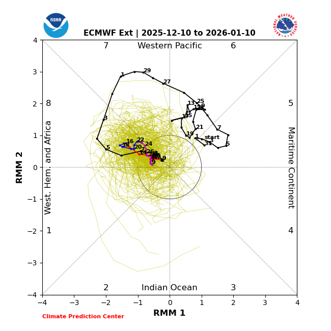
Look at the EURO's phase 8 temperature correlation, showing widespread cold over much of the nation.

Instead of cold and below normal readings, the EURO is showing temperature departures of 30 or more degrees above normal. Houston, we've got a flipping problem! I just want to emphasize highs of more than 50 are not something to count on at this distance. I'm just amazed I'm seeing numbers that even imply anything over 50 degrees.

Anyway, the last thing I will say is that if the wind chill hits 30 below as it could Sunday the 14th, it would feel 90 degrees warmer in 9 days if somehow the Quad Cities hits 60 the 23rd. There's no doubt we are going to warm up for an extended period, it's just a matter of how warm. We are in the home stretch, with the end in sight for this wild 3 week ride of weather. Yowza! Roll weather...TS
TSWAILS.COM expert weather consulting services (CLICK FOR MORE)

Private consulting
Legal forensic services as an expert witness
Public speaking engagements for groups or individuals
Post storm analysis
A private day-long weather school class
Specialized events forecasts
Severe weather seminars
Lectures and training
Climatological services
Meteorological workshops.


Comments