


OUT WITH A BANG...
- Dec 13, 2025
- 4 min read
WINTER WEATHER ADVISORY SATURDAY FOR SNOW
COLD WEATHER ADVISORY SATURDAY NIGHT AND SUNDAY
Our 17-day onslaught of winter weather ends with a bang this weekend, one that features another snow system over the south and a quick but intense shot of Arctic air. For perspective, since Thanksgiving, the majority of my area has seen 10–22 inches of snow. That does not take into account what ends up falling today.

Here's a larger perspective of 14 day snowfall totals, which shows the sweet spot nationally for snow extending over the NE half of Iowa into much of Illinois and Wisconsin.

Many of us have measured 4 to 5 times the amount of snow we typically would see through December 11th. In fact, we've had more snow than northern Minnesota, which believe me is a rarity. My climate guy Steve Gottschalk in Lowden, Iowa has tallied 21.7 inches with more to come Saturday.

Going back to November 28th, temperatures over that 15 day span have averaged 9 to 10 degrees below normal per day.

With these departures expected Sunday, the averages will continue to lower through next Tuesday.

But then look what happens to the 500mb jet stream come Christmas Eve morning. It's realigned itself in a west to east flow around a ridge centered over the SC United States. Arctic air is sheared off over Canada, while mild Pacific air dominates the majority of the continental United States.

These are the average daily temperature departures for the 10-day period December 17th-27th.

The Climate Prediction Center sees the trend and has issued this outlook for temperatures December 20th-26th, depicting very high odds of above normal readings over most of the nation.

That translates to 11, almost 12 consecutive days of highs above freezing in the Quad Cities if the EURO is right.

Temperatures like that will do a number on the snow cover, and by Christmas the GFS shows no place locally with so much as an inch of snow on the ground.

The EURO has 1/2 inch down to my northernmost counties.

There is plenty of time for a last minute change, but It's mind-boggling to me that after today's snow event, much of my area will have had 18–24 inches of snow since November 29th, and yet it is all shown as gone by Christmas. Hard to fathom, but that's the world we live in today, and rest assured climate change has something to do with us getting that much snow and losing it that fast.
GIVE THE GIFT OF MY 5 STAR AIRBNB IN GALENA

Holiday and winter specials are now in effect through March. Let us help you set up a personalized gift certificate that's sure to create a lifetime of memories! Santa Claus approved. Call or text Carolyn at 563-676-3320 for details and our very best pricing. https://www.littlewhitechurchgalena.com/
THE BIG BANG...
Saturday will be one of those days when cold deepens and snow falls, the one exception to the snow will be my northern counties where little if any snow accumulates. Elsewhere, snow starts early and streaks across the region along with a clipper during the day. Dry air will limit accumulation in the north but across the south where strong forcing in the dendritic layer and snow ratios greater than 20:1 will produce 2–4 inches of snow over much of my area along and south of I-80. Further south in some spots in SE Iowa and WC Illinois, especially near HWY 34 could see 5-6 in totals in a narrow 20-mile wide swath. A Winter Weather Advisory is in effect for my counties south of HWY 30 including Iowa City and the Quad City metro area Saturday.

You can see the path of the snow band and clipper as it zips southeast through the central Midwest.

This is the official NWS forecast, showing the sharp cut-off to snow N/NE of HWY 30.

With snow falling into temperatures of 8–10 degrees, it will be tough to keep roads snow free where it falls, but at least it will be a very light powdery type that should be relatively easy to shovel.
Here's what the raw model guidance shows for snowfall as of Friday night. These are not forecasts, just model derived amounts that forecasts are developed from. What we hope to see here is consistency between all the various model solutions.
The EURO

The GFS

The HRRR

The 3K NAM

The 12K NAM

The Canadian RDPS

The NBMv5, a blend of 30 models and ensembles.

Following the snow, an Arctic intrusion envelops the region that is likely to feature temperatures as cold as 10-15 below with dangerous wind chills. The NWS has issued a cold weather advisory that will border on a warning in the north. Wind chills of 20 to 30 below are anticipated across the board.

The EURO has lows in the general range of 7 below SE to 15 below NW.
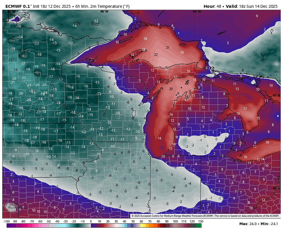
Wind chills near and north of I-80 are pegged at 25 to 30 below zero.

Sunday will be nice and extremely fresh, a fine day to lay low indoors. Highs may not reach zero in spots.

After that, we start digging out of the hole next week, and before you know it, our harsh weather pattern of the past 3 weeks is out with a bang. Bah, humbug Ebenezer! Roll weather....TS
TSWAILS.COM expert weather consulting services (CLICK FOR MORE)

Private consulting
Legal forensic services as an expert witness
Public speaking engagements for groups or individuals
Post storm analysis
A private day-long weather school class
Specialized events forecasts
Severe weather seminars
Lectures and training
Climatological services
Meteorological workshops.


Comments