


CLARIFICATION PLEASE, MUST READ!
- terryswails1
- Nov 24, 2018
- 2 min read

What I wanted to convey in the previous post was that we now have good consensus on where the primary snow band is likely to be give or take 50-75 miles (north or south). Models are not to be taken precisely, they are a guide. Yesterday we had snow to the Minnesota border with two different camps depicting where the heavy snow band would occur.
Today that range is now reduced from 300 miles to 75 or less. Models have converged on a general solution. What you need to know is that if you are on the fringe, maybe just out of the snow band on the models I've shown, you are not yet out of the picture yet. Small track fluctuations are normal at this distance and in a situation like this can change a 1" accumulation to 6 or 7" with a 50 mile bump. Conversely, it could go the other way from 7" to 1". I can't stress enough the sharp cut-off that will be found on the edge of the storm.
Also, if the model says 10" in your area that's not a given. Again, it's a guide that helps us a forecasters determine a reasonable range. Usually, if the track is correct you could expect the final amount to be within 2" of the given number. There is no such thing as exact when it come to forecasting, especially snow. Lots of things can impact the final totals like convective bands, narrow swaths of snow in the primary band where thundersnow dramatically increases amounts in local areas. No way to call that!
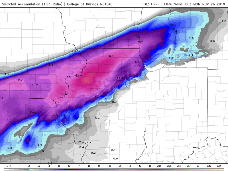
Since my last post I've already had 3 new models and they have inched northward. Now we wait to see if this is a trend on future model runs...including the new EURO. Nothing is entirely set in stone just yet.
Here's the new models. Still close to the previous runs but a bit further north.
The NAM

The 3k NAM

The HRRR
Hopefully we are all on the same page now. Sometimes I forget some of you don't understand the process like me. Sorry about that. Roll weather...TS


Comments