APRIL, YOU CAN HAVE IT...
- terryswails1
- Apr 15, 2019
- 3 min read
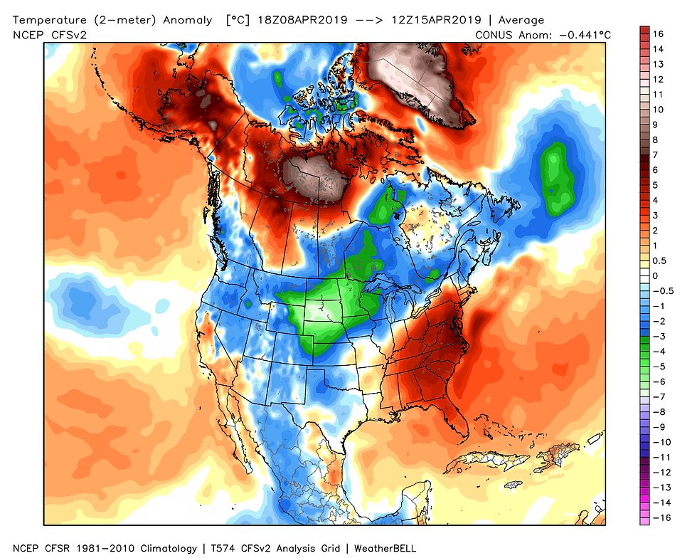
So far the month of April has been nothing to write home about. We've had a few good days but more often than not its been dreary, windy, and cool. Last April was lame as well. Personally, I'm not a fan of April and its fickle ways. Halfway through the month temperatures look like this nationally.

The past week has been especially raw in much of the Midwest. These are the departures for the past 7 days. No thanks!

The upper Midwest and northern half of the Plains have been downright wintry with extreme cold and snow. Just look at these snowfall reports from last weeks blizzard. Through northern Wisconsin back through Minnesota, South Dakota, and NC Nebraska 6 to 24" of snow fell with gusts to 50 mph.

These snowfall reports out of South Dakota are eye popping. 30" is a winter's worth of snow in much of my area.

With this latest storm the seasonal snow totals across the northern half of the country are the most for a winter in more than a decade. All the areas in red have seen at least 4 feet of snow this winter. The dark reds are more like 5 to 6 feet!

Here are some seasonal snow totals and the associated anomalies. EAU (Eau Claire, Wisconsin) has had nearly 100" and is 52.6" above normal for the winter. Rhinelander, Wisconsin has measured 115", its snowiest winter ever.

The latest snow this past weekend was centered over parts of Illinois. A storm system tracked into the middle Ohio River Valley during the day on Palm Sunday 2019 (April 14). It brought periods of heavy snow to the region during the morning and lasting into the afternoon. Snow fell from northeast Missouri into Illinois and SE Wisconsin. The heaviest snow fell in Bureau and Putnam counties were 5 to 8.5 inches of snow was reported. 8.5" fell in Princeton. 5.3" in Chicago at O'hare.

The satellite early Monday morning vividly showed the snow band.

This picture taken in Macomb, Illinois Sunday shows the huge flakes that quickly covered whatever they landed on. It;s the winter that keeps on giving!

I'm happy to report that the next few days will see the return of springlike conditions. Highs both Tuesday and Wednesday will fall into the range of 67-73. The GFS seems reasonabledepicting these highs.
Tuesday:

Wednesday:

Our next weather maker arrives Tuesday night with the threat of showers and storms, especially across the north. Chances will increase across the rest of the area later Wednesday or Wednesday night along a cold front. One trend that's shown up in the past 24 hours is a weaker look to this storm with less rain and severe weather potential. The hi-res models have this for rain totals as of late Monday night. This is a very positive trend with rain totals down by 2-3" since Sunday in some parts of the upper Midwest.
The 3K NAM

The NAM

As of Monday night the models I've seen have not been very bullish showing storm development later Wednesday. That's also a change from previous days, just another trend that needs to be monitored. That said, this is the SPC outlook for severe weather Wednesday. This gets updated by morning and I look for some downward adjustments.

To sum it up, Tuesday will be a better day and after a week of cool windy weather that's just fine by me. Roll weather...TS


Comments