


STRONG STORM FOR THE HOLIDAY WEEKEND...
- Nov 29, 2019
- 5 min read
PLEASE CONSIDER THE VALUE...TSwails.com has been far ahead of the competition in catching and forecasting the trends of our extreme weather the past few weeks. It takes a great deal of commitment, passion, and knowledge to do that. Now that I'm no longer in television, this is my job and that's the reason I'm asking for a voluntary subscription fee of $12 dollars a year, one dollar a month to keep TSwails going. Together we can create one of the best, most unique, and reliable weather sites in the Midwest. Your contribution of 3 cents a day, allows me to stay free of the corporate world and pour my energy into doing what I do best, forecasting the weather! We hope you see the value and hard work that goes into the site everyday. You support in any way is sincerely appreciated. Thanks and roll weather. To donate click on the secure green box below

STRONG WEEKEND STORM FOR THE MIDWEST:
The second major storm in 4 days is expected to bring a wide variety of weather back to the Midwest this weekend. Currently advisories for winter weather are in effect over this part of the upper Midwest.

As with the previous system, most of the precipitation with this disturbance in my area will come down as rain. However, by Sunday as the upper air low passes over the region it will drag a pocket of cold air aloft with it. That results in a window of 6-8 hours Sunday where there will be enough cold air and instability for snow showers.
The best forcing will be well to the north and that is where the heavier snow accumulations will be (Minnesota, Wisconsin, and northern Iowa). Since precipitation is going to be showery in nature in my area, coverage is going to be spotty, meaning pockets or bands of snow up to an inch could fall. Other areas not far away might see only a light dusting. As it stands now, I would plan on minor accumulations. Worst case an inch, best case a small dusting. The exception would be near and north of HWY 20 where there could be some isolated 1-2" amounts. Due to recent mild temperatures, some of the snow might have a tough time sticking to roads unless it's a quick heavy burst.
Here are the latest snowfall forecasts:
The EURO

12K NAM

3K NAM

The GFS
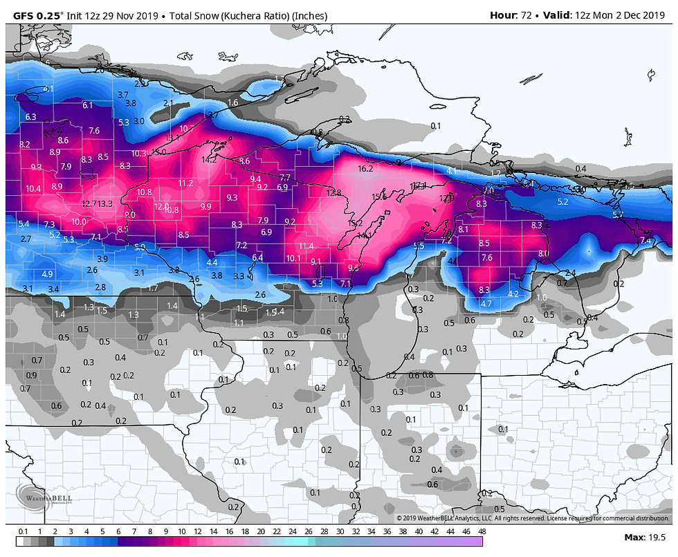
As you can clearly see, this is going to be another big snow for the upper Midwest and travel north of the Iowa border in Minnesota and Wisconsin will be difficult, especially Saturday night and Sunday.
Around my area, the rain does not kick in until tonight and it will remain cool and occasionally showery into early Saturday night before the snow showers follow Sunday. Yuk! Roll weather...TS
SANTA CALLING! Christmas is only a month away. Are you looking for something special for that hard to buy for person? Maybe you just want to treat yourself for being on the nice list! Well, here's an idea that can "give" any weather enthusiast a lifetime of pleasure. It's called WEATHER SCHOOL. What a person experiences here will open up the world of forecasting for years of enjoyment to come. Consider giving the gift of weather. Better hurry, only 14 seats left. You can get all the details below.

TSwails.com is offering a very special and unique opportunity to learn first-hand the ins and outs of weather forecasting with one of the best meteorologists in the Midwest along with his team of expert meteorologists.
That’s right… You want to forecast right along with Terry Swails, well now you can. He’s teaching weather with TSwails newest program called WEATHER SCHOOL. The opening bell rings this January and you can be a member of the very first graduating class. The one-day forecasting seminar for weather enthusiasts will be held at his home in January. It’s not your typical run-of-the-mill school. There will be no tests, but Terry, Rebecca, and Nick will cram your head with so much knowledge, it’ll be spinning like a tornado before the day is over
You want to know the essential online sites to use for models, radar, and the basic weather tools? DONE! You want to understand the structure of models and the role they play? DONE! You want to be able to construct forecasts from the ground up? DONE!
WEATHER SCHOOL will be presented in a seminar-type format where you'll have the ability to ask questions and dig deep. You’ll get the scoop on data acquisition, model analysis, severe weather, and actual forecasting from the big dog himself, T. Swails. With 43 years of experience and an uncanny ability to break the science down, you’ll open the door to forecasting like never before.
Along with the head master T. Swails himself, meteorologists Rebecca Kopelman and Nick Stewart of KGAN TV will be there to lend their knowledge and experience to the discussion. It will be fun, informative, and factual! This is the day for you to see, feel, and experience what it’s like to be in the hot seat of a meteorologist.
The seminar will be held January 25th and will last from noon until 5:00pm. We have limited seating and the cost is $99 dollars per person. A catered lunch will be provided. Again..not a lot of seats so reservations with a pre-payment are required. Sorry, no refunds. If there’s enough interest, a second session will be added in early February. To register or get additional information send an email to carolynswettstone@yahoo.com
GIVE THE GIFT OF WEATHER. This might be the perfect gift for that hard to buy for person this Christmas. Along with a WEATHER SCHOOL admittance voucher, TSwails will send a special holiday greeting to your weather enthusiast if you give the gift of weather with the TSwails touch!
WEATHER SCHOOL AGENDA:
WELCOME AND INTRODUCTION
Purpose: To help weather enthusiasts understand the basics of forecasting and apply the knowledge and techniques learned to construct personal forecasts.
Session 1: DATA ACQUISITION
The essential on-line sites for models, observations, satellite and radar images, and general weather data.
Session 2: ANALYSIS:
Determining your objective goals. Short term, intermediate, or long-term. Understanding the process of analysis and its relationship to forecasting.
Model options and choices. What to use and when!
The GFS, EURO, NAM 3k, NAM 12K, Canadian, HRRR, MJO, ensembles, teleconnections, etc.
Locating, learning, and knowing what’s essential to make a reliable forecast.
The art and science of model interpretation: Using and understanding model output. Its called guidance for a reason!
Learn how to analyze key parameters such as:
Surface and upper air data
Vorticity and energy
Precipitation output
Wind and pressure
Session 3: MAKING A FORECAST FROM MODEL GUIDANCE
A simulation of the basic process using model output.
BREAK: A 25-30 minute recess to enjoy a catered lunch…
Session 4: SEVERE WEATHER:
Thunderstorms, tornadoes, derechoes, and squall lines.
Soundings. What are they and why should I care?
Instability (CAPE) vs (CIN) Critical interaction involving moisture, heating, and forcing.
Uncovering the ingredients of a severe weather set-up.
TVS signatures. What to look for on radar.
Role of SPC vs NWS, and your local TV station regarding the warning process.
Simulated model driven forecast of a severe weather event/tornado outbreak
Session 5: WINTER STORMS:
The key ingredients required for significant winter storm:
How to forecast the rain snow line.
How to forecast snow totals from QPF
Determining totals from snow ratios.
What to look for at the surface and at upper levels (500 and 850mb)
Model bias and determining the storm track
Simulated model driven forecast of a significant Midwest winter storm
QUESTION AND ANSWER SESSION
An open period for attendees to ask questions regarding relevant topics or issues discussed during the day.
CONCLUSION:
Some final words of inspiration from the events headliners
Once again, to reserve a spot or ask questions send an email to carolynswettstone@yahoo.com See you when the bell rings! Roll weather...T. Swails


Comments