


STRONG STORMS MOVE THROUGH OVERNIGHT
- May 17
- 3 min read

Good evening everyone! I wanted to get an update as many start heading to bed on the potential for storng storms overnight into early Monday morning. Overall, the forecast from last night remains mostly on track with severe weather ongoing to the west including damaging wind gusts over 70mph and a few tornadoes. Tornado Watches extend through central Iowa, southern Minnesota and northwest Missouri until at least 3 a.m. with more watches possible if the storms maintain strength.


The watches above were issued prior to 9 p.m. central time. More watches may be needed farther east to include eastern Iowa and northern Illinois if storms maintain their strength. The tornado threat should slowly diminish with damaging wind being the primary concern through the night. With that said, a few tornadoes remain possible given the strong wind shear in place.

The HRRR has storms entering eastern Iowa, southwest Wisconsin and northern Missouri as of 2 a.m. CDT. Some potential exists for these storms to be severe with, again, damaging wing being the main concern with this activity.

By 4 a.m. the HRRR has the line crossing the Mississippi River into northwest Illinois, including a risk to the Quad Cities. While storms will be weakenin as they trek east, there will remain some potential for severe weather. Make sure you have ways to get warnings in case significant severe weather moves in your direction. A Weather Radio is a great option, otherwise make sure you have Wireless Emergency Alerts (WEA) enabled on your phone. You will get the alert for major severe weather including tornadoes and destructuve wind.

An additional severe weathe risk remains in place Monday where we can expect much of the same. A Level 4 of 5 risk, a Moderate Risk, includes northeast Kanas. Storms are forecast to develop in the afternoon and move east through the evening and overnight.
Similar to tonight (Sunday night), the storms will likely be in a weakening state by the time they reach the Mississippi River, however a few tornadoes and damaging wind gusts remain possible with storms.
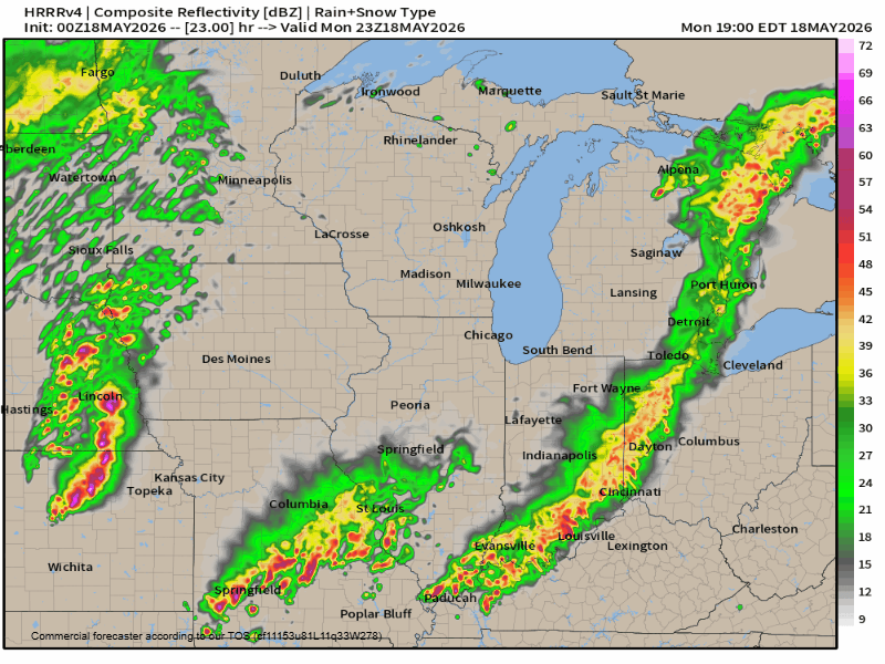
The HRRR has storms moving into the Quad Cities region late Monday night, likely after 3 a.m. once again. The modeling shows these storms weakening, but overall a risk for damaging wind gusts and a tornado or two will be in place.
One major caveat with the weather prediction models tonight is exactly how Sunday night's storms will affet Monday. There is some potential the threat may be displaced farther south, and we are actually seeing that in tonight's HRRR run. Notice the strongest storms look to mainly be south of the Iowa/Missouri boder. That is likely due to how Sunday night's storms will impact the placement of an outflow boundary.

The HRRR shows some afternoon recovery across southern Iowa which would be the fuel for Monday/Monday night's severe weather potential. However, instability may be in shorter supply as an outflow boundary from Sunday night's storms pushes the move extreme instability well to the south, into southern Missouri and Illinois. I would expect some potential for the official SPC severe risk to change based on morning data.
BOTTOM LINE - We will once again have a risk for severe storms Monday evening/night locally, with damaging wind gusts being the greatest concern. A few tornadoes remain possible as well, especially depending on how much afternoon recovery we have across Iowa and the placement of any other boundaries.
Have a great week, friends!
-Meteorologist Nick Stewart


Comments