HOW LOW DO WE GO...
- terryswails1
- May 5, 2020
- 2 min read
Some impressively cold air (capable of producing records this weekend) is engulfing the Midwest in two phases. The first was ushered in Tuesday by a system that brought rain to a large part of the central Midwest. In some spots highs struggled to reach 45 degrees at a time when norms are up around 70. Here's the Doppler estimate of rainfall since late Monday morning.

Conditions will improve Wednesday and Thursday as a weak ridge of high pressure follows Tuesday's disturbance. With the addition of any sunshine highs should rebound nicely with the addition of the strong solar insulation reaching levels near or slightly above 60. However, the air remains cool aloft and afternoon heating could result in some brief isolated showers. They look very spotty.
The next push of cold air which is the real deal surges south Thursday night. It could trigger a few showers in the SW half of the area but currently the bulk of the rain looks to pass south of the region.
Friday, an unusually potent upper-low is forecast to drop southward from the Hudson Bay into the Great Lakes. You can clearly see the connection to the Arctic.

Strong cold air advection on Friday will allow 850mb temps to bottom out between -4 and -7 C which is in the lowest 1% of early May climatology. The unseasonably cold air mass with highs in the 40s and 50s, combined with gusty NW winds of 25-30 mph, will make it feel very brisk through the day....more like Halloween!

As a surface high moves in Friday night, winds will subside allowing temps to quickly fall with the core of the cold air directly overhead. If this scenario is realized (as it is currently shown) lows are likely to plunge into the upper 20s and low 30s. Friday night is the best chance for frost or a freeze through this extended period. With temperatures below freezing for a lengthy period of time sensitive vegetation could be severely damaged if not protected.
These are the temperature departures for Friday at 5,000 feet. This will be the coldest day of this outbreak which will cover plenty of real estate around the NC United States.

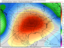
Overall the pattern continues to have a cool look to it well into mid-May. Here's the temperature departures on the EURO for the coming 10 days in 5 day increments.
Days 2-7

Days 5-10.

If that sounds bad to you, read this little paragraph from the NWS in Portland, Maine where I now reside...
LONG TERM /WEDNESDAY NIGHT THROUGH MONDAY/... If you are excited for summery wx...just close the blinds and stop reading now. Highly amplified flow over North America will leave us with a pattern more reminiscent of a Jan snowstorm than a sneak peek at summer. And in fact it may lead to May snow.
If anybody can appreciate May snow its me but I can honestly tell you, I'm ready for a stretch of good old fashioned summer weather. My patience is running thin! Roll weather from Portland, Maine...TS


Comments