TROPICAL RAINS TUESDAY....
- Jun 7, 2020
- 2 min read
Tropical Storm Cristobal made landfall in Louisiana and will now continue to trek north. It will bring the threat of heavy rain and flooding to the Midwest. Here's the latest forecast from the National Hurricane Center:

It's not unusual for tropical systems to influence the weather in the Midwest. What is rare and unusual is how far west the track is (which has been shifting to the east). Here's a look at some of the historical track of tropical systems in and around Iowa:

Even though the track has been shifting east, there is still going to be lot of moisture and rain around the low pressure system and areas to the west. Here's a look at the European model on Tuesday:

Right now the Weather Prediction Center has a slight risk for excessive rainfall in parts of the Midwest but I wouldn't be surprised to see this upgraded.

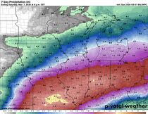
Here's a look at the model outputs for rainfall through Tuesday night. Here's the total on the Euro:

The GFS:

The NAM:

As you can see there are differences still on exactly where the heaviest rain is placed (and how heavy it is). There is the potential for two to four inches of rain with the levels of tropical moisture coming in. Showers and thunderstorms through the day Tuesday into Wednesday will lead to rises on rivers and streams and flash flooding (especially due to recent heavy rains).
Prior to the heavy rain we will have a hot and humid day Monday:

Temperatures will be knocked back Tuesday as Cristobal moves through and due to the widespread heavy rain:

We'll continue to update you on the latest forecast with Cristobal and where the heaviest rain will fall.
RK


Comments