MORE SEVERE WEATHER TUESDAY....
- Jul 13, 2020
- 1 min read
A cold front will move through the Midwest Tuesday and bring the chance for strong to severe thunderstorms. Here's the outlook as of Monday evening, and it will likely change by Tuesday morning:

Tuesday will start off dry across much of the area. As a result temperatures will take off into the 80s:

Instability will build through the day and lead to the potential for strong storms as well as heavy rain.

That will be enough for thunderstorms to be on the strong side late Tuesday afternoon and evening and through the night. Strong winds and hail will be the main threats with these thunderstorms. Along with the chance for flash flooding due to locally heavy rain. There is enough spin in the atmosphere for tornadoes, but due to the late timing of storms the chances are on the low side as it appears right now.

Above you'll see an animation of the storm system moving through Tuesday through Wednesday, I'll break it down here. Storms will move in from northwest to southeast late Tuesday --

These are the ones that will be strong. Storms continue through the night and then may back off some early Wednesday morning. On Wednesday, near the front, there will be the chance for some additional showers and thunderstorms. That will likely be in southeastern Iowa into Missouri and Illinois.

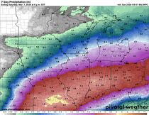
When it's all said and done there may be one to two inches of rain with up to three inches in some spots.

Once again western/central Iowa misses out on some much needed rain. And unfortunately rain chances will likely be pretty low for the rest of the week.
RK


Comments