LATE SUMMER CHILL, NOT FOR LONG...
- terryswails1
- Sep 19, 2020
- 1 min read
The Midwest weather pattern was dominated by high pressure and fresh fall air Friday afternoon. Under a mix of sun and clouds highs struggled to get past the mid 60s in many areas. Dubuque only reached a high of 62. These were late day readings.

The majority of my region was running 10-12 degrees below normal at that time.

Below you can see the big 1031mb high that will be parked over the region Friday night. That will induce strong radiational cooling as it enables mostly clear skies and light winds within a dry air mass.The days have also been getting shorter for 3 months and that is beginning to take its toll.

The 3k NAM has this for lows Saturday morning. The first few hours of the day will be crispy.

Later in the weekend the high gets well off to the east and return flow sets up southerly winds creating what should be a mild dry weather pattern next week. The EURO shows this for total rainfall through next Friday. I'm hearing crickets!

As for temperatures they should be trending upward, especially next week. Here's the 10 day meteogram for Cedar Rapids.

The overall warmth and dryness is reflected in the MJO (Madden Julien Oscillation) You can see phase 5 is expected to flourish the rest of September.

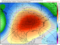
Phase 5 analogs in September look like this. The EURO model output is very much in sync with what its MJO output reflects.

Not very exciting for me but good for those of you who like things nice and quiet. Enjoy and roll weather...TS


Comments