


WARMING TEMPERATURES WITH A SIDE OF RAIN
- Dec 15, 2025
- 2 min read

Another brutally cold morning is in place across the region with sub-zero temperatures taking over Monday, but in the coming days temperatures will be gradually moderating and a storm system in the short term will bring rain, not snow. A look above shows the long-range high-resolution modeling early Thursday with light rain showers sweeping through around sunrise. This system is rather moisture starved so heavy rain is not a concern, but we might at least get some rain accumulation to clean some of the salt off the cars.

The latest forecast from the Weather Prediction Center continues to keep the rain rather light, with totals locally in the 0.10" to 0.25" range. This will not be a big rainmaker. In fact the bigger story with this system will likely be the wind once again.

The rain showers will be in the warm sector of this system in the morning hours. At the long range above you can see the strong wind gusts once again knocking on the door by late morning Thursday which will send temperatures falling. A chance for some light snow/wintry mix with this front will be a possibility, but at this point no accumulation is expected.

The blended temperature forecast this week shows 40s on the board Thursday, but a major caveat with that is the fact that will be early as temperatures are expected to fall through the second half of the day as the aforementioned cold front swings through and brings the wind and colder temperatures. Friday morning looks to be quite cold once again, perhaps pushing single digits, but the overall extended period remains near-to-above normal.
I went more in detail on the extended period in yesterday's post so instead of rehashing that information, I encourage you to check out yesterday's post as not much has changed.
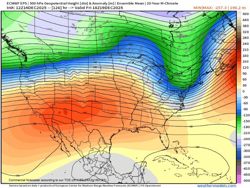
Significant ridging remains likely later this month into Christmas week with moderating temperatures. This will likely also usher in a quieter weather pattern for the same period.

Analogs are indicating near to below-normal precipitation probabilities Dec. 22-25 which makes sense with the ridge pattern setting up. Notice out west, however, how active that pattern will be. There will likely be some significant snow pack building up in the Rocky Mountains! I cannot rule out any travel disruptions around the holiday, but at least as of now no major storm systems appear to be likely. As always we will continue to monitor things!

For example, the full run of the European Ensemble out through December 29 has little snowfall locally. This is quite a signal for limited snowfall potential during an otherwise normally active period of the year. Pattern just gets completely shut off.

In fact, if you look at the reasonable worst-case scenario, or roughly the heaviest snow produced by the 50 members of the European Ensemble (90th percentile of cases), there is a single inch of snow in the Quad Cities between now and Dec. 29. That is remarkable as there are usually always phantom winter storms in the extended period that produce some heavy snow.
Have a wonderful week, friends!
-Meteorologist Nick Stewart


Comments