A BIT OF SNOW, BUT SHORT-TERM OUTLOOK SLIM
- Feb 1
- 4 min read
THE FUTURE DEPENDS ON YOU. IF I DO NOT REACH MY FUND-RAISING GOAL THIS WILL BE THE LAST YEAR OF THE SITE...

As you know, TSwails.com is a no-pay site, existing on voluntary personal donations. Every year I ask those of you who find value in the site to make a financial donation you feel is worthy. Please reflect on the number of times you have visited us in the last year. If the information or knowledge you gained was valuable, it's my sincere hope you will join the loyal group of contributors that's kept TSwails.com operational since 2013. I'm suggesting $20.00, which is roughly 4 cents a day. Less than 4% of my readers donate, so your gift, no matter the size, is not only appreciated; it helps immensely.
QUIET START TO FEBRUARY

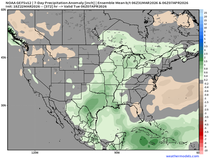
While the recent trend in temperatures has been quite reminiscent of winter, the snow has been and continues to look rather benign for the short and mid-range forecast. No significant winter storms are threatening not only locally, much much of the country is looking to trend towards calmer weather after a wild stretch of weather especially for the eastern US. Analogs (above) reflect rather high probabilities of below-normal precipitation through the first week of February.

A fairly weak system will slide through the area Sunday and bring some light snow. The main impacts will be during the afternoon hours with a few periods of moderate snowfall possible. The total accumulation will likely sit in the 1-2" range with lesser totals southeast of the Quad Cities as the system falls apart.

Official forecasts from the National Weather Service overall maintains this 1-2" snow potential with the 2" totals more likely to the north across southeastern Minnesota and northeast Iowa. As mentioned totals get less, especially south of I-80, as the storm system weakens with time.

The season (for the Quad Cities) is officially near normal in terms of snowfall but it is incredibly front loaded. We haven't had a one-day 1" snowfall since December 13! That is quite a long stretch and the chance of 1" with Sunday's clipper is limited. In fact in the last week we technically just dropped below the "normal" line due to the lackluster stretch, but it's pretty close.

Heading north up the Mississippi River, Dubuque is running about 4" above normal for snowfall and has seen a little more snow scattered through the season. We even had a 2"+ snow event back on January 21 that is really helping carry the season higher and upward.

Temperatures so far this winter have mainly been on the colder side of normal with one month to go in meteorological winter. While not significantly colder it is on the colder half. East-central Iowa for example is ranked 80th of 134 year on record in terms of average temperature.
So where is the snow?

Take a look at these incredible snow totals across North Carolina Saturday/Saturday night with areas near and south of Greensboro running over a foot of snow! Even the Atlantic Coast and Outer Banks of North Carolina have multiple reports more than 10" of snow. Remarkable levels of snow! It certainly makes me yearn for the "big one" that has been difficult to find in recent years, although we got quite the event with this past Thanksgiving.
Today does mark the fifteen-year anniversary of one of the best winter storms I ever got the chance to experience. The Groundhog Day Blizzard of 2011 walloped the region with intense snowfall. I was in Chicago at the time and picked up two feet with numerous instances of thundersnow. This was one event I will never forget! I took the video above as the storm started if you are interested.

That event 15 years ago dumped more than 1-2' of snow from Oklahoma through the Great Lakes with much of our area right in the midst of it. Remarkable event!

Back to reality, long-range ensemble forecasts do not look particularly exciting for snow prospects locally. The next two weeks on the European Ensemble barely show an average total of 2" locally which for this time of year is very limited snow potential. It really comes down to no strong signal of a stronger storm system.

The latest Climate Prediction Center forecast is well in line with this quiet pattern through the first full week of February as it maintains elevated chances of below-normal precipitation. Enjoy the snow Sunday, as overall chances are bleak for a bigger winter storm in the week or two ahead.

Terry late last week laid down a deeper dive in the longer-term outlook and I recommend you checking that out. I think once we get passed the first week of February there may be more prospects for the white gold as the global pattern attempts to reload. That likely will resonate once the PNA (above) dips back to neutral/negative territory. Something to watch for in the second half of February in particular. SERIOUSLY, IF TERRY DOES NOT MEET HIS FINANCIAL GOALS, THIS WILL BE THE LAST YEAR OF HIS SITE. THE FUTURE IS UP TO YOU...

On a personal note I wanted to highlight a major work mission coming up in the next week. Artemis II is expected to carry people around the moon for the first time since 1972 via the SLS rocket, pictured behind me there. This is an incredibly important launch currently scheduled for Super Bowl Sunday, Feb. 8. When I covered Artemis I back while on Iowa's News Now I really felt the desire to find a way to be a part of this historic mission, and the future of building a permanent presence on the moon, and I am forever grateful I have that chance. Make sure to keep an eye on the upcoming launch! Exciting times ahead!
-Meteorologist Nick Stewart


Comments