


RUNAWAY COLD...
- Jan 31
- 5 min read
THE FUTURE DEPENDS ON YOU. IF I DO NOT REACH MY FUND-RAISING GOAL THIS WILL BE THE LAST YEAR OF THE SITE...

As you know, TSwails.com is a no-pay site, existing on voluntary personal donations. Every year I ask those of you who find value in the site to make a financial donation you feel is worthy. Please reflect on the number of times you have visited us in the last year. If the information or knowledge you gained was valuable, it's my sincere hope you will join the loyal group of contributors that's kept TSwails.com operational since 2013. I'm suggesting $20.00, which is roughly 4 cents a day. Less than 4% of my readers donate, so your gift, no matter the size, is not only appreciated; it helps immensely.
LIFE IN THE DEEP FREEZE...
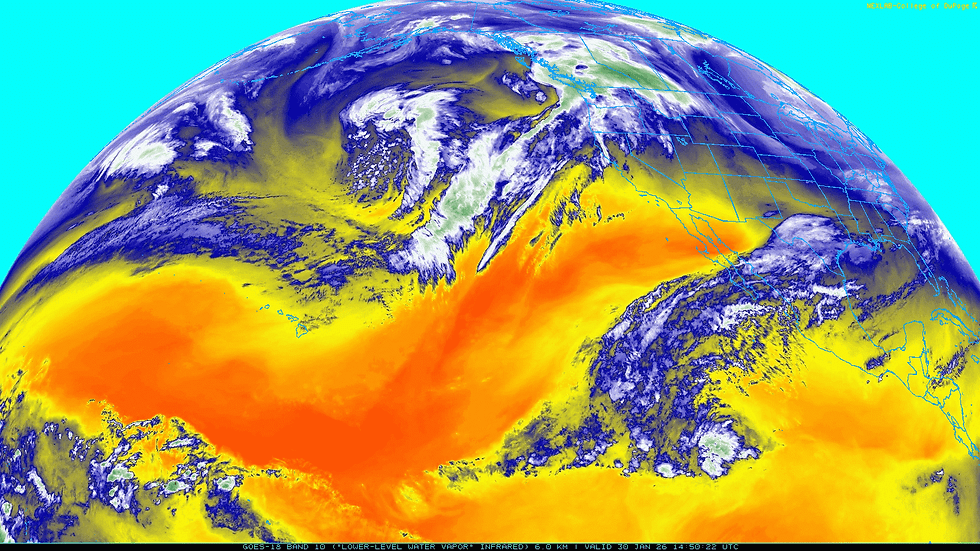
For two weeks now we've been stuck in the deep freeze of winter trying to run down a warm wind. That old breeze has been more than elusive thanks to a massive western ridge and a deep east coast trough. We're in what's known as a positive PNA, which stands for Pacific North America oscillation. The satellite image below is a great example of such an atmospheric alignment, showing storms in the Pacific being forced to turn north as they buck the ridge over the west. That buckles the jet, forcing the northwest flow that keeps things dry but very much on the cold side.

One of the unfortunate aspects of a strong NW flow in January is that we are in what is climatologically the coldest time of the year. Westerly winds off the Pacific would steer warmer air our way, much like we enjoyed the first half of the month. Now that the steering currents are coming out of the polar regions, our air masses have a distinct tie to the Arctic. Friday, as in much of the recent past, an impressive 1048 high pressure was delivering much below normal temperatures and extremely dry air to the eastern half of the country. Sioux City Friday evening was reporting a pressure of 30.70", which signifies a huge dome of dense, cold Arctic air.

With a similar air mass controlling our weather since mid-month, we've been locked into highs in the single digits and teens with subzero lows. Here in Dubuque, Saturday marks the 15th straight day without reaching freezing (more than 360 hours). We are working on adding to a string of 9 consecutive days with a low of zero or colder. During that 9-day period, we haven't been above 17 degrees, and I'm getting irritable. Fortunately, the region doesn't have a heavy snow cover, or it would be even colder.

Here is some good news. The frequency of below-zero temperatures reached its statistical peak locally around January 21st. You will notice the frequency declines steadily in February, and it takes some doing to get below zero after March 10th. Patience, grasshopper, we are on the right track

I've pointed this out numerous times, but this has been such a schizophrenic month. 10 years from now, if you looked up the average January temperature through January 30th, 2026, in the Quad Cities, you would see it was 21.4 degrees. Knowing the average is 22, you would say it had been a pretty average January. What you would not know is that for the last 15 days, temperatures averaged about 12 degrees below normal. Previous to that, the first 15 days were running 11-12 degrees above average. Take a look.
Temperature departures the past 15 days, January 16th through the 30th

Temperature departures January 1st through the 15th. I rest my case regarding the manic personality of the month.

Earlier in the post we discussed how the positive PNA has been forcing our hand as far as cold goes. It's also kept us dry. Below you can see the PNA is projected to go negative around the 9th.

The 500 mb heights in a negative PNA are indicative of a trough over the west. Currently the trough is over the east, so that's an important reversal that might look something like this: cold and wet west, warm and dry east.

Where things get interesting is that every other teleconnection (the AO, NAO, EPO, and WPO) is also negative, and those analogs imply cold weather. So what I'm surmising is that temperatures will warm, but only moderately, as the PNA transition takes place, eventually allowing readings to get closer to normal. You can see the trend towards seasonal readings in the longer term.

After that it really becomes interesting as the colder teleconnections fight the trough which is expected to develop over the west. Such a combination would allow moisture to overrun the colder air in place locally. That creates an active storm track that features warm air advection. That increases our chances for precipitation and potentially a stripe of snow from the Plains to the East Coast. The question is, can we get anything to spin up into a decent storm that penetrates the Midwest? It's on the table, but it's far too early to see. Notice those storms in the Pacific below that are being blocked from entering the west. If the trough forms as expected, they should start entering the west before ejecting E/NE across the country. This could go on much of the month. That's the theory, but with the blocking at higher latitudes associated with the -NAO, the heaviest precipitation could remain just to the south. It's darn near impossible to call this early. In general, I don't think things have really changed too much from my thinking yesterday.
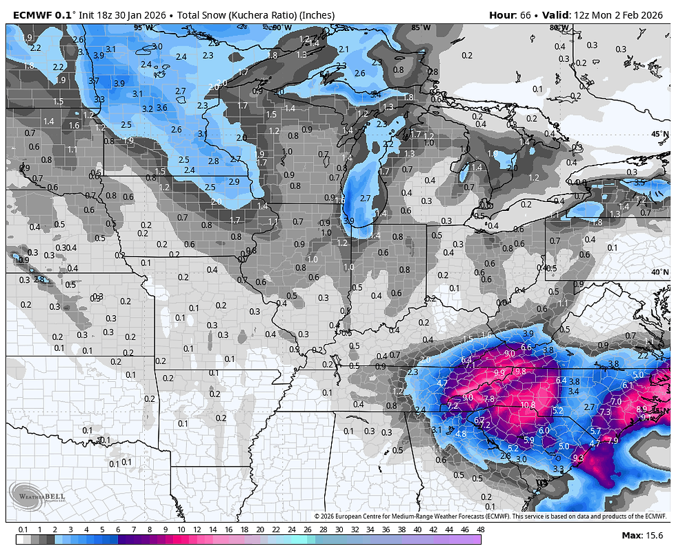
Just for kicks, the ensembles of the EURO show this for snow through March 17th. This is an average of 51 members. Some higher and some lower. Notice, though, it represents my idea of an active west-to-east storm track somewhere from the Plains east. I'm not interested in amounts (they are irrelevant at this distance). What I like is the trend, especially since it reflects some of my current thinking.

The control, a single run, is really hot from Minnesota into the Great Lakes. That seems a bit far north to me.

Well, the last day of January and the weekend as a whole will be cold but not in a brutal way. Typical stuff for this time of year. Highs of 20-25 on Saturday, but a little back door chill settles in Sunday with readings down into the upper teens to low 20s then. Sunday is also a day when we see at least a chance of some light snow in the afternoon and evening thanks to some warm air advection ahead of a weak trough that drifts southeast. Accumulations on the EURO are in the range of 1/2" to an inch, maybe a bit more in the north. Nice and powdery and nothing major.
The EURO shows another chance at some light snow Thursday from a NW flow disturbance. It's too far out to make any assessments regarding accumulations, but it doesn't look impressive right now. Perhaps enough to track a cat or two. Roll weather, and if possible, please consider a donation to the site. SERIOUSLY, IF I DON'T MEET MY FINANCIAL GOALS, THIS WILL BE THE LAST YEAR OF THE SITE. THE FUTURE IS UP TO YOU...T.S.


Comments