A BUMP BEFORE THE OLD DIPSY DOO...
- terryswails1
- Sep 29, 2020
- 2 min read
Tuesday was another day of cool condition around my part of the central Midwest. Clouds were strung out from north to south around the back side of an upper air low spinning through Illinois.

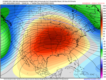
That kept temperatures in the low 60s and for good measure a few pop corn showers played around with little in the way of impact. Energy diving south in the NW flow aloft will continue to deepen a trough the next 72 hours that encompasses much of the central and eastern U.S. Here's the 500mb flow Friday.

In the short term forecast (the next 5 days) temperatures are expected to grow even colder as spokes of energy deepen the amount of cool air within the overall pattern. The 5 day departures Wednesday through Sunday appear this way.

Friday looks to be the coldest of the bunch with departures that look like this on the EURO.

Actual highs on Friday are likely to remain in the range of 50-55.

One of the looming questions is frost potential Friday night. Important differences exist between the GFS and EURO with regard to the amount of clearing. The GFS is clears skies and keeps the ridge in place overnight allowing for maximum radiational cooling. That's what you look for in a frost set-up and sure enough the GFS shows that potential with some spot reaching the upper 20s. Lots of readings in the low to mid 30s.

The EURO limits the clearing providing a blanket of clouds that stops temperatures from falling and it produces lows about 10 degrees warmer eliminating the threat of frost and freezing temperatures. I would say at this point it's too early to pick one over the other and a compromise in the middle is a good way to go until we get more evidence one way or the other. This is what the EURO has for lows Friday night.

In terms of precipitation, aside from some isolated showers or sprinkles Thursday in the northeast, the next real chance for rain arrives Saturday with a clipper that digs into the mean trough from the NW. Again there are differences in timing, speed, and strength but both models are further southwest on the track and that means more of my area has a shot at rain than yesterday. The biggest difference is the EURO closes the upper air low off resulting in a slower solution keeping rain chances intact through Sunday night. I can see reasons for the EURO solution so would lean towards it but again its a low confidence forecast, especially in the duration category which impacts amounts. Here's what both models show for rainfall totals.
The EURO

The GFS

Meanwhile, Wednesday should be the best day of the week with partial sunshine and warmer readings well into the 60s ahead of the next shot of cold air. Enjoy it. Roll weather...TS


Comments