


A CHANGE WILL DO YOU GOOD
- Aug 5, 2025
- 3 min read
After all the heat, steam, and storms during July, a change in the weather did us good! Temperatures have returned to tolerable levels and more important, dew points have gone from the range of 75 to 80 to a comfy spread of 55-60, well below what you would expect to see in the dog days of summer. To highlight the change, I'm showing high temperatures in July VS. those of August in the Quad Cities. Over the last 6 days, the average high has been 78 degrees with the final day of July at just 76. Talk about a breath of fresh air!

Looking at temperature departures over the past 5 days, the coolest weather in the nation relative to average has been found right here in the heart of the Midwest.

With moisture and lift displaced well to the west and south, rainfall has evaporated and Monday was the 5th consecutive day with no measurable precipitation. We never went more than 4 days without a measurable rain the entire month of July.

PLAN A TRIP TO MY 5 STAR GALENA AIRBNB

My 5-STAR AIRBNB just outside of Galena still has some openings this summer. All of our ratings are 5 star! We take pride in the amenities and the cleanliness. If you book now, we'll take off $200, and we can eliminate AIRBNB fees and additional costs that will save you big bucks. Other discounts apply. Call or text Carolyn at 563-676-3320 for our best deal of summer. See more at https://www.littlewhitechurchgalena.com/
WARMER AND WETTER WITH TIME...
As you can see in the predicted 5-day temperature departures Thursday through Tuesday of next week, some changes are on the way thanks to a return flow of southerly winds.

The 500mb jet stream flow shows a heat dome nosing into the southern Plains late this week. That opens the door for warmer air and, of course, higher humidity. It also brings the "ring of fire" into play for at least 2–3 days starting this weekend.

In fact, if you look at the precipitation that is forecasted Saturday through next Wednesday, you can see an arch of heavier rains extending from Iowa to Wisconsin and NW Illinois. That approximates the position of the ring of fire, or the northern edge of the heat dome, where storm clusters like to play. These ridge riders usually have the capability to emit heavy rains. We'll need to see where the exact position lines up in coming days to determine where the threat would be greatest. At this point, the situation does not appear to be as robust as what we went through in late July. For now, there is poor continuity between the EURO and GFS as to where the boundary sets up and how heavy the rains will be. As you can see, the EURO is noticeably lighter on amounts in my local area than its counterpart, the GFS the next 10 days.
The EURO

The GFS

Temperatures, while trending warmer, are slightly cooler on the GFS as opposed to the EURO. At this early stage, I prefer a middle ground approach between the two, with the EURO showing a warm bias recently. Here are the meteograms for each model over the next 2 weeks.
The GFS

The EURO

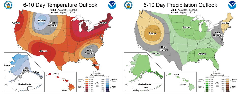
Overall, guidance is in relatively good agreement that the 6-10 day period will be warmer and wetter than average. Certainly closer to the type of weather that's more typical in early August.
At least for now, outside a stray brief shower or sprinkle Tuesday, quiet conditions will continue to rule the roost through the remainder of the week before thunderstorm chances pick-up later in the weekend. Enjoy and roll weather...TS


Comments