


FIRST SNOWFLAKES
- Nov 5, 2025
- 4 min read
From the looks of the latest data, confidence has increased over the past 24 hours that many of us will see our first snowflakes of the season this weekend. There is still some question whether or not it will accumulate, but there is evidence that some part of the area may see enough to stick on elevated surfaces such as grass and whiten things up a bit. Roads however are likely to be too warm for any accumulation, so no problems are expected. The best of both worlds as far as I'm concerned.
For those with inquiring minds, the first measurable snow in my area (0.1") doesn't arrive in the north until mid-November, while the area south of HWY 30 holds off until the 21st-24th. The far south (HWY 34 south) doesn't see its first measurable snow until November 26th or later.

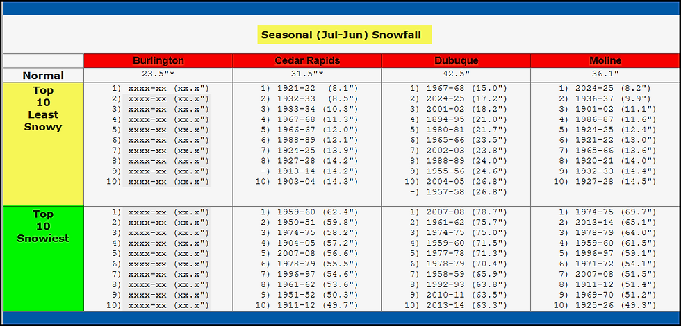
As for the first 1.0" total, that is usually the first week of December, although Dubuque is earlier at November 29th. You can also see the earliest and latest dates of the two thresholds.
Below are the top 10 snowiest and least snowy winters. Quite a range in there, from 8-15" on the low end to 62 to 78" on the high end. The last really big winter for snow locally was 2013-2014. We are due for a good one!
Before we get to our first crack at snowflakes, we've got 3 more days of paradise, meaning highs in the mid 50s to mid 60s. Wednesday and Thursday should be more in the range of 55 to 60, with Friday potentially reaching the low to mid 60s. By the way, Wednesday morning looks rather windy, with gusts up to 30mph+. There is a small window for showers Thursday night, they should be light and most likely found from the Quad Cities southeast.
Behind a front, colder air begins to punch into the area Friday night. The leading edge of it hangs up near the Missouri border, where it will await a clipper late Saturday afternoon and evening. The EURO has shifted south with the track of the surface low, and is now in agreement with the GFS that it tracks near or just south of Keokuk early Saturday evening.

Initially, precipitation is likely to start as rain Saturday afternoon, with surface temperatures in the upper 30s to low 40s. However, as the low tracks east, colder air aloft will deepen and become entrained in the system, especially towards sunset. Rain will mix with or even change to snow before exiting Saturday night. Evaporative cooling will be a critical process as to how soon and complete the transition is. Despite nearly identical tracks, the EURO is just warm enough to keep the majority of the precipitation rain. The GFS has remained staunch in its depiction of an earlier switch to snow and actually shows some slushy 1-2 inch totals. Boundary layer temperatures are going to be really marginal, but 850 readings are shown at -3 to -5 C by the time precipitation ends. After dark, that could be enough to mix the rain with snow or even change it to snow for a time.
As was the case yesterday, the deterministic EURO produces little in the way of snow, but the EURO ensembles have up to 1/2" of snow in the northwest Saturday night. While it's not much, most spots get at least measurable snow of 0.1 to 0.5".

The ensembles of the GFS are a bit more generous, indicating 1.00 to 1.50 inches.

If we can't get the snow transition Saturday night, the EURO rotates another lobe of vorticity in Sunday and Sunday night that comes with a stout shot of cold air. There's a pretty good chance snow showers should erupt that could produce a dusting in spots. If nothing else, we all have a good chance of seeing our first snowflakes by Monday from these 2 opportunities this weekend.
VISIT US AT MY 5-STAR GALENA AIRBNB.

My 5-STAR AIRBNB just outside of Galena is a premier Midwest destination and a guest favorite! We take pride in our perfect rating, amenities and cleanliness. Take advantage of our fall and winter specials and instantly save $200. Book directly with us and eliminate AIRBNB fees and additional costs that will save you cash. Other discounts apply. Call or text Carolyn at 563-676-3320 for our best deals of late fall and early winter. See more at https://www.littlewhitechurchgalena.com/
DOWN GO THE TEMPERATURES SUNDAY...
After highs in the 60s Friday, lows Sunday morning are shown in the low to mid 20s.

Toss in a 30mph NW wind, and wind chills early Sunday are shown in the range of 9-13 degrees areawide. In other words, it will feel 50 degrees colder in just over a days time.

However, the cold air makes a hasty retreat Tuesday as the MJO makes a rotation in phase 6, which in November analogs to mild, above normal temperatures. Check out these 5 day temperature departures for the period November 12-17th.
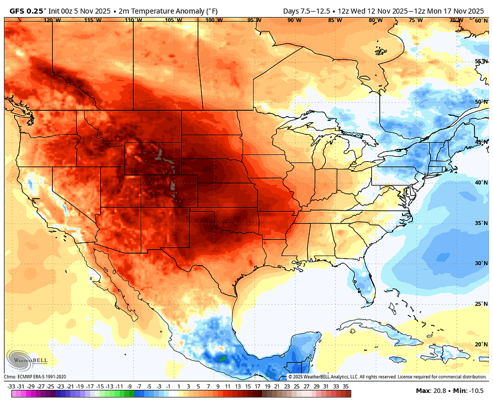
That certainly is the spitting image of the phase 6 temperature composite in November. That leads to high confidence we stay mild in the 50s and 60s through at least November 18th, a trend that was anticipated.

It's after that we should begin transitioning to colder weather by Thanksgiving. That's where things stand for now. Enjoy the day and by all means, roll weather...TS.


Comments