


A GOOD SOAKING RAIN
- May 19, 2025
- 3 min read

Monday through Wednesday looks like the ideal setup for some drought-denting (maybe busting) rainfall for the Midwest and Great Lakes region. Plenty of moisture overrunning a warm front with limited severe weather as an added bonus. Models generally are painting a widespread swath of 1-3" from the Dakotas down to the southern Mississippi River Valley.

The forecast mean off all of our high-resolution convective-allowing models shows nearly all of Iowa with at least 1.5" of rainfall, and pockets of 3"+ across areas of Missouri. Heaviest rainfall will be along the warm front which will be located in southern Iowa/northern Missouri.
THE EURO

THE GFS

THE NAM

Breaking the models out individually, 72-hour rain totals are generally in pretty good agreement. They all show localized maximums potentially topping 4", albeit with it in different spots.

The amount of moisture available is not expected to at record levels, but in rare territory for the time of the year. Precipitable water, or a measurement of the amount of water in the atmosphere, will be in the 99th percentile across Missouri. This is the rich supply of Gulf moisture that will fuel heavy rain across the Midwest!

Heavier showers and thunderstorms move into the area mid/late afternoon Monday and will stick around through much of the day Tuesday with some light wrap-around showers Wednesday. The bulk of the heaviest rain will be later Monday into early Tuesday.

A Slight and Marginal risk for severe weather push into portions of Iowa, Illinois and Missouri Monday. The areas most likely to see the severe weather will be south of the warm front where the air will be more unstable. This generally will be southern and southwest Iowa into northern Missouri. The main hazards will be large hail and potentially a tornado or two. Higher chances of tornadoes, some strong, will be farther south into southern Missouri and deeper io the Southern Plains of Oklahoma.
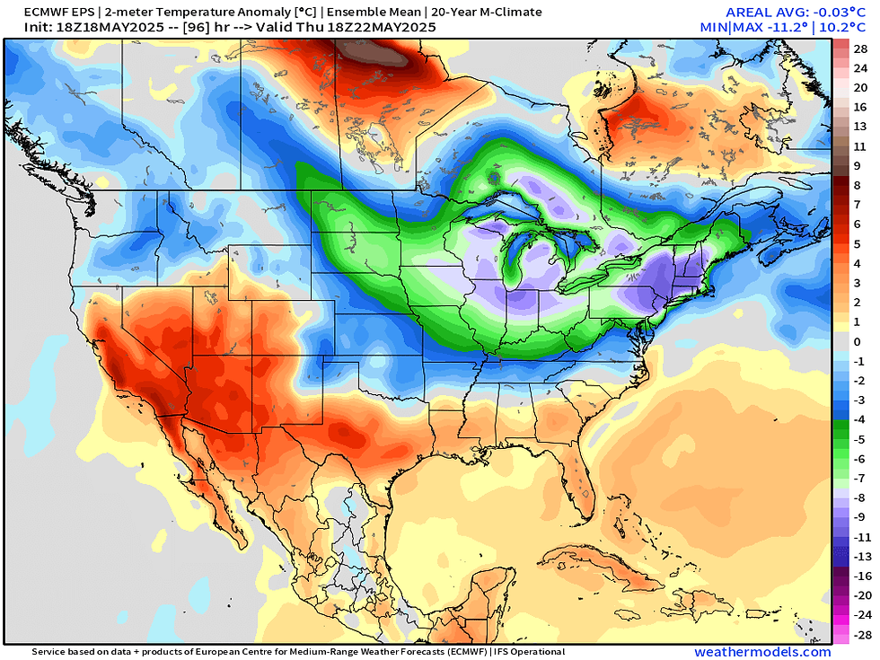
Behind the rain and storms we will see cooler temperatures. Thursday will clear out with sunshine but temperatures are forecast to run 5-15 degrees below normal for the time of year across the Upper Midwest. While we will warm up heading into the weekend, near-to-below-normal temperatures are in the forecast for the tail end of May.

Upper air patterns will favor more northwesterly flow for the eastern US with troughing over New England. This may actually set up a more active pattern as well with disturbances riding over the ridge in the central US tapping into Gulf moisture.

This is somewhat highlighted by the latest Climate Prediction Center outlook for precipitation. Generally the area is on the line separating wetter and drier than normal conditions. I would not be shocked if by the time we reach this May 24-28 period it trends more towards the wetter side of things.

The CPC outlook closely matches what analogs are showing for conditions heading into next weekend. We may be sitting right on the battle zone... make sure to stay updates on how things trend.

With that I will wrap it up. Next weekend I will be on the hunt for tornadoes during my annual "Chasecation," or storm chasing vacation. The next two weeks will take me from the Canadian to Mexican border in the Central US on the hunt for the most dangerous and photogenic severe weather. A very early forecast looks like a Kansas, Oklahoma and Texas trip for the first few days but a lot can change! Have a great week, friends.
-Meteorologist Nick Stewart


Comments