


A MINI THAW
- Dec 7, 2024
- 2 min read
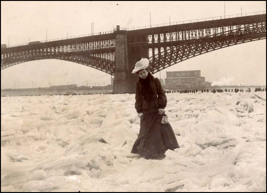
Friday afternoon, I was admiring the ice that's formed on the Mississippi over the past week. Even the main channel is pretty well covered up here in Dubuque. A far cry from 9 days ago when she was wide open from Iowa to Louisiana. It will break out some this weekend as a mini December thaw is set to arrive. Something they were hoping for back in the winter of 1905 when this picture was taken of the river frozen solid enough to walk across all the way to St. Louis. By the way, just saying, I'm digging that ladies hat.
UP AND DOWN AND ALL AROUND
Going forward, the weather pattern looks to become what we call progressive. In other words, weather systems will regularly be coming and going. That's likely to produce ups and downs in temperatures but, due to limited moisture and the inability for any storms to amplify, little in the way of rain or snow. Here's what the EURO indicates for total precipitation going into December 14th. Meager is how I would describe it.

The dryness is a trend that's been going on since mid-November. Saturday will be the 19th consecutive day with no measurable precipitation in the Quad Cities. Back to that junk again.

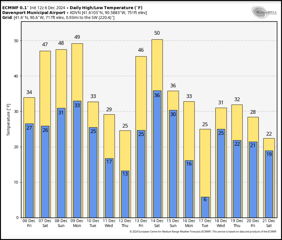
As far as the coming temperature extremes go, it looks like a full on roller coaster the next week. Up, down, up, and back down again. The EURO shows this for readings in the Quad Cities the next 2 weeks.
FLASH SALE AT OUR GALENA AIRBNB
40% Off a weekend or weekday stay in December-February. Call or text Carolyn now at 563 676 3320

GIFT CARDS AVAILABLE...
You can see the first volley (a warm one) occurs this weekend when mild readings are in place with a storm track that looks like this.

Next Wednesday it's back to cold with a pretty impressive trough plowing through the Midwest December 11th.

December 15th, it's back to mild weather as ridging returns. This back and forth is a classic example of the progressive pattern that's in our future.

After December 15th, there are hints of a system that could produce rain and perhaps some snow in parts of the Midwest. However, cold air looks to be lacking and phasing questionable, thus I doubt much in the way of snow this far south. Here's what the operational GFS shows for snow through December 23rd. I very much doubt what it shows for totals in Missouri and Illinois.

The EURO is a more reasonable scenario, with the bulk of any snow through December 22nd shown over the upper Midwest.

Once again, the MJO in phase 6 through Christmas indicates big challenges for snow and cold to have much (if any impact) on the central Midwest through December 25th. My soul is troubled by the negative signs with 17 days until Santa rides, but I remain hopeful for the miracle of a white Christmas. Have a terrific Saturday and as always, roll weather...TS


Comments