


A SULTRY SURGE...AGAIN
- Aug 15, 2025
- 4 min read
Numerous times since July, we've faced the prospect of extremely high humidity due to dew points commonly found in the tropics. We've had a bit of a break the past 2 days, but once again, the cat is out of the bag and another onslaught is headed our way.
Here's a graphic from the Iowa Mesonet, which shows dew points for the month of July at the NWS office in Davenport. Each day of the month, the highest dew point is indicated in red. 25 of the 31 days were 70 or above, which falls into the classification of very humid to oppressive. Never once did they go below 65 which is still considered humid.

Here's a scale referencing how a specific dew point makes it feel.

Even this month, only 3 of the 14 days have seen dew points been below the humid category of 65 and those days still qualified as slightly humid.

Figuring in the heat index, how it feels with the temperature added to the moisture, it was consistently in the range of 90 to 103 degrees 19 of July's 31 days.

This month has been better, but still had a run of 4 consecutive days when it felt 90 to 100 degrees.

PLAN A VISIT TO MY 5 STAR GALENA AIRBNB

My 5-STAR AIRBNB just outside of Galena still has some openings this summer. All of our ratings are 5 star! We take pride in the amenities and the cleanliness. If you book now, we'll take off $200, and we can eliminate AIRBNB fees and additional costs that will save you big bucks. Other discounts apply. Call or text Carolyn at 563-676-3320 for our best deal of summer. See more at https://www.littlewhitechurchgalena.com/
BACK INTO THE SAUNA...
Our recent respite is rapidly coming to an end with the development of another heat dome aloft that Saturday evening is centered near St Louis at 500mb.

It allows heat and humidity to enter the pattern as it unfolds Friday. By Saturday, highs on the EURO are in the low 90s.

Dew points are shown soaring into the oppressive range of 75 to 79.

Heat index values of 101 to 105 are common on the EURO Saturday.

The GFS (most likely too high), is far more brutal with heat index readings of 105-110.

If current trends hold, similar conditions will be found Sunday and Monday and at a minimum, heat advisories are likely to be issued. The one factor that could change the game are mesoscale convective systems (MCS) that could form Saturday night into Sunday night that could generate cold pools and outflow boundaries strong enough to temper the heat, particularly in the north. The evolution of these storm clusters is yet unknown and is something that needs to be watched in coming days.
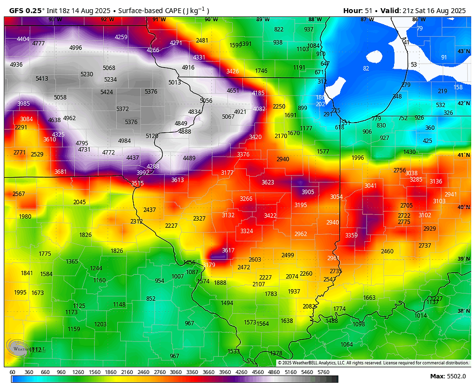
One thing is for sure, if we reach the heat index values indicated, potential energy is going to be explosive. The EURO has CAPE (instability) exceeding 6,000 j/kg in NC and NE Iowa Saturday evening.

The GFS is slightly tamer but still a lion near 5,000 j/kg.
One of the key factors creating the instability is available water vapor that is maxing out at 2.00 to 2.25 inches.

That moisture plum remains in place just to our north Saturday into Monday, perhaps Tuesday. That's right where the ring of fire will be situated. It's the breeding ground of storm clusters (MCS's and MCV's) that flourish in such an environment. Any storm that goes up in that zone can not only be severe, it can produce excessive rains of 1–2 inches in an hours time. The storm clusters are also big enough to produce cold pools which sustain them for multiple hours. We've seen this movie over and over again recently. As I've been mentioning for several days, it's quite possible, one of these convective events could form near the Iowa border or southern Minnesota in the evening after peak heating and track SE into some part of my area. Saturday night it's possible, and Sunday night it's even more likely.
The 3k NAM actually shows an event Saturday night that produces excessive rains over northern Iowa that catch parts of my area. This model (convective allowing) only goes out until midnight Saturday, and it's still in an active phase, moving southeast. The EURO and GFS do not even see it on their latest runs.

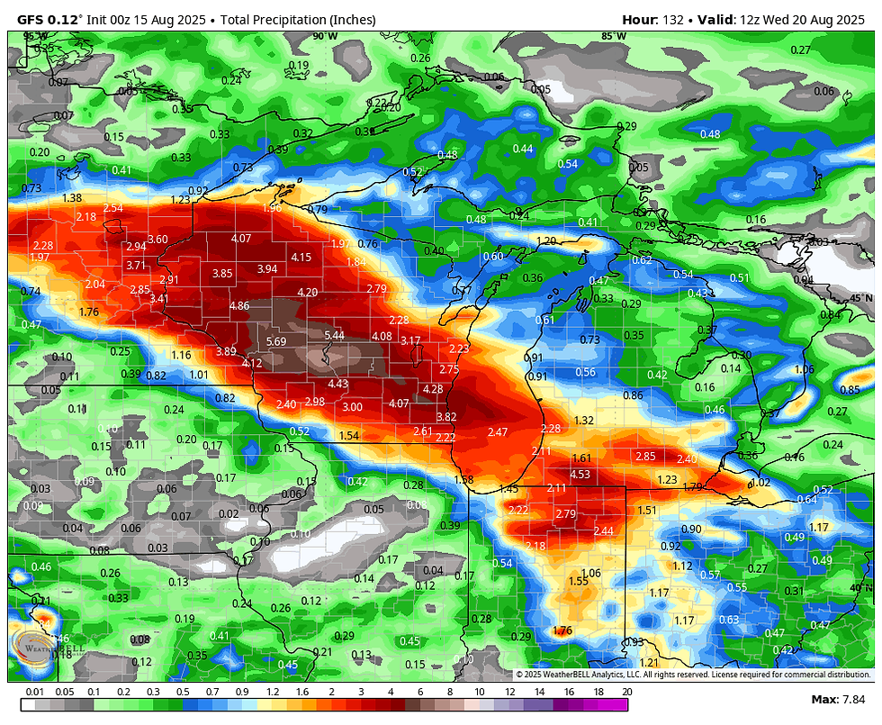
The GFS and EURO are more smoothed and try to pin the highest totals just north of my area. That said, the GFS has made a southward push. The EURO remains consistently further south on its rain shield, but still keeps those nasty 2-4 inch totals just north. My hope is they are correct, as another significant rain event on our saturated soils would be problematic. I may be off base, but there are concerning trends that some of this heavy rain finds its way further south into my area with time. We'll need to be vigilant about that possibility. Here's what the GFS and EURO indicate for rain totals Saturday night into Tuesday.
The GFS
The EURO

One final note that has surfaced today is that guidance is slower breaking the heat dome down next week. That allows the muggies and occasional rain chances to linger into Wednesday before the heart of this round of steam is broken. With that, here's to a happy Friday! Roll weather...TS


Comments