


AFFECTION, FOR PERFECTION...
- Nov 15, 2025
- 4 min read
When you add it all up, Friday was a perfect 10. The ingredients of sunshine, dry air, a slight breeze, and highs of seventy are exceptionally hard to bundle in mid-November. My guess is that the odds of that combination are at best 1 percent. The hardest element to achieve is the light winds. Typically, 70 degree days in November come with gusty south winds up to 30 mph, which tempers some of the warmth. Some say there is no such thing as perfection, I say Friday was as close as you are going to get on November 14th.
Had there been more wind and slightly more mixing, we may have seen more record highs. Most places were 1-2 degrees short. Lowden did tie their existing mark of 73.
Here are Friday's records, with Friday's actual highs listed on the right in red.
Burlington: 75, 1964 74
Cedar Rapids 75, 1964 72
Dubuque 70, 1971 68
Moline 75, 1971 73
A breakdown of highs around the region Friday afternoon.

Readings as warm as what we saw are 23 to 26 degrees above normal. Some spots in SC South Dakota were as much as 35 degrees above normal.
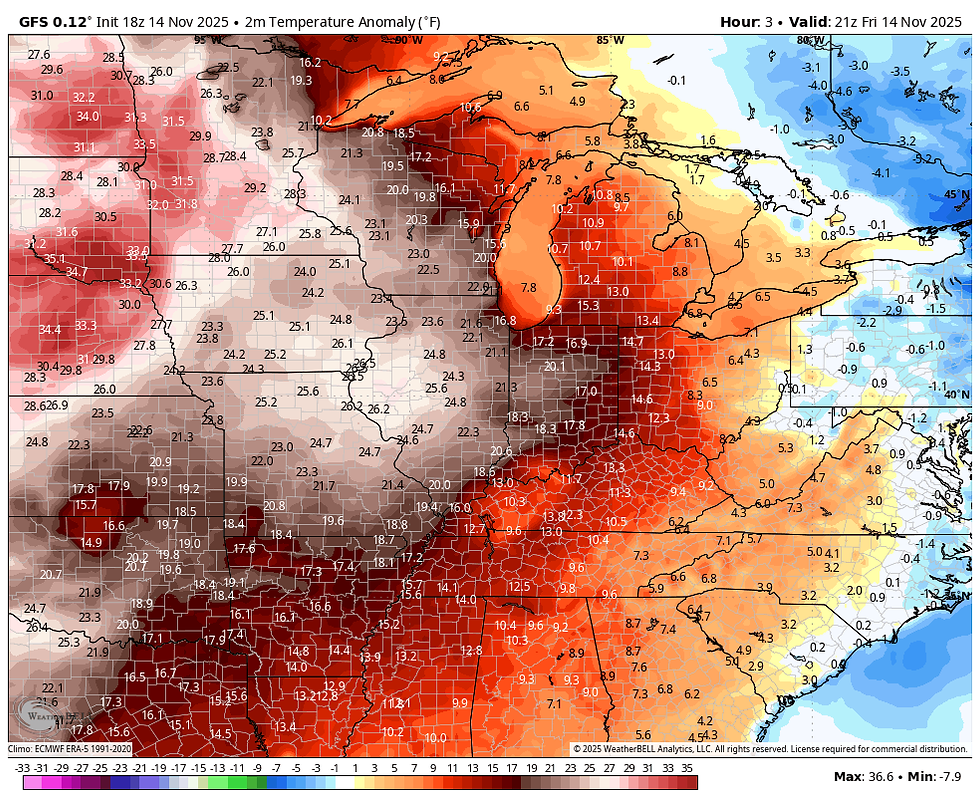
It caps off a remarkable week of temperatures at the NWS office in Davenport, where readings went from 20 Monday morning to 72 Friday afternoon (a swing of 52 degrees)! At least we went in the right direction.
GIVE THE GIFT OF MY 5 STAR AIRBNB IN GALENA

Holiday and winter specials are now in effect through March. Let us help you set up a personalized gift certificate that's sure to create a lifetime of memories! Santa Claus approved. Call or text Carolyn at 563-676-3320 for details and our very best pricing. https://www.littlewhitechurchgalena.com/
A COOLING TREND
Temperatures will be down a little bit in the north Saturday thanks to a cool front which sweeps southeast in the morning. Arriving before peak heating, it will kick up the winds and snip a few degrees off highs, especially in the north. Still, aside from the winds, it should be another good day with readings well above normal ranging from 65 north to 72 south. Records could be challenged in Moline (at 72 in 2001) and Burlington (at 74 in 1950).

Sunday and Monday will be a bit of a reality check, with highs back in the upper 40s to low 50s, much closer to where we should be.
After that, the pattern becomes more active and much harder to forecast, with several short waves diving into the mean trough situated over the southwest. Models are notoriously challenged in this type of set-up to determine how much phasing (or interaction) there is between the northern and southern branches of the jet. We know energy is going to come out of the trough, but the strength of the surface reflection and where it travels will be determined by how much energy is bundled. At this distance, that can get very tough to see after 5 or 6 days with the short wave lengths involved.
We do know that precipitation of some magnitude arrives Monday night into early Tuesday with the lead impulse that kicks out of the SW trough. Models are generally keeping amounts under 1/3rd of an inch, nothing to write home about. The best chances for the higher totals looks to be north of I-80.
The GFS

The EURO

While there's reasonable consistency on amounts, precipitation type is radically different. The GFS manages to dig up enough cold air for a snow band of an inch or two Monday night in the far north.

The EURO says no, no to that idea showing a nothingburger.

I am leaning heavily on the snowless solution of the EURO. The GFS had a similar problem last weekend, showing more snow than there actually was. It smells fishy.
With plenty of clouds around Tuesday and Wednesday, I look for cool readings with highs low to mid 40s north and upper 40s to low 50s south.
Beyond that, phasing and timing issue really show up with another burst of energy coming out of the southwest. The potential is there for a significant system with heavier precipitation, but track, intensity, and timing are not in sync at this distance. Moisture should be more abundant, increasing the chances of a decent system with higher and more widespread rain totals. Additionally, CAPE is shown (convective allowing potential energy) which means thunderstorms could be a factor. We'll know more in coming days, but something should materialize out of the set-up.
MJO HEADED FOR COLDER PHASES
Reflecting on what could be a wintry pattern change ahead, the MJO solutions of the EURO and GFS continue to show an amplified push into phases 7 and 8 by the end of November based on convective trends in the tropical Pacific. That analogs to colder temperatures in late November and December.
The EURO extended MJO to December 14th

The GEFS extended MJO, also out to December 14th. Slightly slower but even more amplified.

The cold for snow is shown to be in place by early December, with 7 day temperature departures on the GEFS looking like this, December 5th to the 12th.

Here's snowfall on the GFS ensemble through December 18th

The EURO ensemble snowfall during the period November 28th to December 30th.

I'm really surprised at the consistency in the overall trends displayed the past 5 days. They say, the trend is your friend...we shall see. In the interim, another balmy day is in order Saturday before cooler air steps up to the plate later in the afternoon. Have a terrific day and roll weather...TS

TSWAILS.COM is now proud to offer expert weather consulting services, including:
Private consulting
Legal forensic services as an expert witness
Public speaking engagements for groups or individuals
Post storm analysis
A private day-long weather school class session
Specialized meteorological needs
Severe weather seminars
Call 563-676-3377 or email terryswails1@gmail.com


Comments