


AIN'T NOTHING IN THE TANK...
- Feb 25
- 5 min read
AN IMPORTANT UPDATE TO REPORT.

Thanks to 341 of you special people, I have reached 93 percent of the funding I need to get the sight through another year. I just need a little more help to get over the hump. If you use the site daily, find it informative, or make financial decisions based on it, please consider a donation. Any bit helps to keep it going in its no-pay format. Nick and I will work hard to bring you the reliable value you have come to expect the last 13 years. The future is up to you. Let's get it done. Thank you for your help!
KEEP YOUR TANK FULL, WORDS TO LIVE BY
We all know what happens when the tank runs out of gas. It's pretty much the same with the atmosphere, No moisture, no rain or snow. The graphic below shows the amount of water vapor available for precipitation around North America. Moisture is there over the parts of the Pacific and Atlantic, but the land masses of the continent are void.

This is what's shown for water vapor in the Midwest Wednesday. 1 to 2 tenths of an inch is the general range. Not much better than the Sahara!

Below are the anomalies, which means for a typical February 25th, water vapor levels would be closer to 8 to 9 tenths of an inch.

I bring this up because it's the kiss of death for this clipper that models were all fired up about for a snow threat three 3 days ago. Slowly but surely guidance has been coming to grips with the fact the tank was close to empty and snow numbers have been sinking like the Titanic. The EURO was the first to jump ship and for the last 2 days have kept the region void of anything more than a dusting, and that was in the far southwest. The GFS and HRRR have also come down on amounts, but show enough saturation in the dendritic zone to pinch off an inch in far SE Iowa and WC Illinois. Personally, I think that's wishful thinking and doubt much more than a dusting to 1/2 ends up falling. Here's the raw model snow output. The first three are the driest options in the EURO camp. The last two are the 1" options favored by the GFS.
The EURO

The 3k NAM

The Canadian RDPS

The GFS
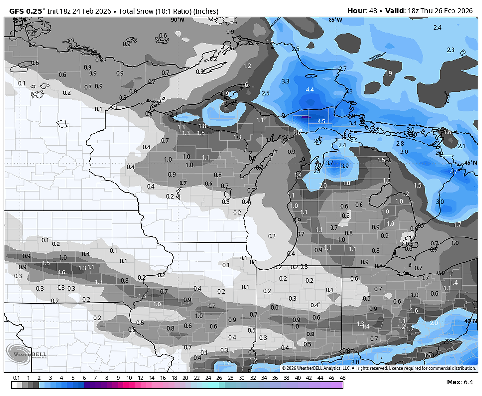
The HRRR

One thing we will see is an increase in mid and high level clouds, especially in the south as the forcing works on the meager moisture. Before any light precipitation develops towards evening, temperatures will warm to about 30 north to 44 south, a pretty healthy spread.
With the forcing gone by Thursday, some return flow kicks in during the afternoon sending highs into the upper 40s to low 50s making for a respectable day. Full on warm air advection punctuates the region Friday for a very springlike day. With at least partly sunny skies, highs should shoot into the range of 58 north to 66 south.

For those interested, those numbers are 15 to 23 degrees above the norms. Yes sir, I'll have another...

Sadly, its a one day warm-up in the north as a cold front settles southward Saturday. It's impacts are most pronounced in the north where highs will struggle to get above 30. Further south, readings look better where the far south flirts with 50.

Even with the spread, at midday Saturday most spots will be 23-27 degrees colder than just 24 hours earlier.

There is also a slight chance of some light snow across the far north Saturday afternoon near HWY 20 as a fast moving disturbance streaks across the baroclinic boundary situated over the region. Most of the accumulations (1-2") are shown just north of there from far NE Iowa into Minnesota and Wisconsin.

A SUNDAY NIGHT TWISTER...
Sunday looks to be a cold dry day. However, in a new twist both the EURO and GFS have an over-running snow event on the table Sunday night. A strong west to east thermal boundary sets up near the Missouri border, similar to what I showed above on Saturday. Upper air energy ejects east along the boundary to spark precipitation. It appears much of my area remains cold enough to be in the position of seeing accumulating snow as warm moist air over-runs the colder dense air locally. This (warm air advection) provides the lift and forcing for a band of snow.
Being a fairly new trend its essential to note that it's far from certain how far north the precipitation band will ultimately get. If you are optimistic the GFS is your pal. It brings up to an inch of of liquid precipitation to much of my area. Most of it snow from I-80 north. The amounts are so high and unlikely I won't even put them up.

If you're more pessimistic, try the EURO on for size. It brings nothing more than a third of an inch to my area with less than 1/10th in the far north. Basically, its all snow.

As much as I would like the GFS to verify for the volume of needed precipitation it shows, I am not seeing the upper air support necessary for it to be that aggressive and far north. On top of that, it typically is overdone on amounts, particularly this early in the game. Both models have little if any surface reflection, which means dynamically the system is driven by upper air support. I would prefer some sort of surface low. Throw in the fact we are in a six month dry spell where everything seems to find a way to miss us, and yea, I'm pretty skeptical of what the GFS is selling.
I did pull the ensembles of the EURO and GFS to show what they are indicating for snow Sunday night. The southward scenario of the EURO and its members gives a mean that looks like this.
The EURO ENSEMBLE

The GFS ENSEMBLE has double those amounts with snow up into southern Minnesota and Wisconsin. Doubtful.

There are some reasons for optimism, but I have serious doubts about this system bringing much more than light to perhaps moderate precipitation in the south, and I'm discounting the GFS entirely. I'm playing it down and very tight to the vest until I see more that recent trends have merit this far north. If nothing else, there are lots of forecast challenges ahead beginning with the ups and downs we'll be seeing in our temperatures the next few days. No doubt about it, Friday is the pick day of the next 7. Make today a strong one and roll weather...TS. ON A MORE SERIOUS NOTE, IF I CAN'T MEET MY FINANCIAL GOALS, THIS WILL BE THE LAST YEAR OF THE SITE. IF YOU LIKE THE CONTENT, THE FUTURE IS UP TO YOU. T.S. 93% to my goal.


Comments