


ARCTIC HOUNDS SET TO HOWL
- Jan 14
- 4 min read
After a month of relatively mild, quiet weather, the Arctic hounds are stirring, and it won't be long before they howl a chilling song. Winter is coming back, my friends, and the next 2–3 weeks have the potential to be both cold and snowy, certainly snowier than the last 30 days. It's hard to get a specific handle on snow more than 7 days out, but I certainly see much greater potential the last week of January. The ensembles of the EURO show this for amounts the next two weeks (at a 10:1 ratio). Most likely ratios will be higher than that due to colder temperatures, which increases them. By the way, the EURO has 51 ensemble members, each with slightly different inputs. The mean is the middle ground solution of both higher and lower snow projections. Some members show solutions that are twice as high as the means, up around 10 inches.

Tuesday morning, the EURO ensembles showed 20-30 percent odds of 6 or more inches in the coming 2 weeks. Those odds have been going up the past 24 hours, and I suspect that trend will continue going forward.

This is what the EURO ensemble mean shows for temperature departures in the same 2-week stretch ending the 28th. The cold will be gradually be backing (retrograding) to the southwest by months end.

Already, the ensembles indicate 50 to 60 percent odds of temperatures at least 10 degrees colder than average somewhere in that 2-week period.

The operational model (a single run) is already way colder than that, showing readings 9-13 degrees below normal per day in the week 2 period, January 21 through 28th
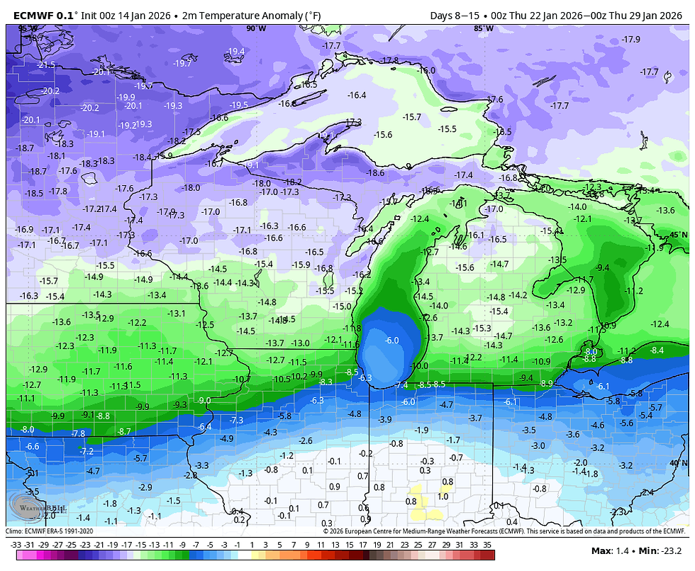
In fact, by Monday morning, the EURO has readings 20–25 degrees below normal locally.

That's producing wind chills of 17 to 27 below, with lows of -4 to +2.

Also of interest, is the fact the EURO is laying down a couple inches of snow by the end of the weekend. More on that coming up.
HOT DEALS IN JANUARY....

A January weekend, (4 GUESTS FOR $499 total) My AIRBNB outside of Galena is ready and waiting. Enjoy our unique, fully renovated church. It's an AIRBNB guest favorite with 5-star reviews. Warm and cozy, even in the winter. Minutes from Galena. Call or text Carolyn at 563-676-3320 for details about this very special deal. https://www.littlewhitechurchgalena.com/
THE WRITING IS ON THE WALL...
The bottom line is that not only are models on to the wintry trend, so are the teleconnections such as the MJO, the AO (Arctic Oscillation), the EPO, (Eastern Pacific Oscillation), The NAO (North Atlantic Oscillation), and others. Confidence has reached high levels that some harsh weather is in our future, especially when you see a 500mb jet that looks like this January 19th. That big ridge off the Pacific Northwest means business, buckling the jet into a cross polar flow.

Things could get interesting for a snow system somewhere in the Midwest when the storm track evolves into this position the 26th. Cold air is deeply entrenched locally, with the baroclinic boundary close enough to the east to allow warm advection snows into the region.

The surface pattern looks like this. This is a way out, meaning changes of some magnitude are likely, but it's a great look for cold and snow and shows the potential on the table with such a pattern.

THE NEXT 5 DAYS...
Wednesday will be a raw day with cold air advection ongoing. Strong winds up to 30 mph combined with nearly steady temperatures in the low to mid 20s will be a sign of things to come (the tip of the iceberg). Thursday doesn't look a lot different from a temperature standpoint, but with winds returning to the southwest, the warm advection should bring clouds and perhaps a few light snows Thursday night. Amounts up to an inch are possible.
Friday through Sunday, a complex scenario involving a couple of clippers and multiple disturbances in the NW flow will create the forcing and instability for periods of light snow. The next wave of light snow is expected later Friday afternoon and evening and appears to be minimal, generally less than 1/2 inch. Scattered snow showers could again pop up Saturday afternoon, with a minor impulse (perhaps a dusting).
A more significant clipper is possible late Sunday, and it has a better shot at delivering 1 to perhaps 2 inches of powder, with amounts dependent on the track still being resolved. This system really cranks up the winds on its backside Sunday night that starts delivering Arctic air and the bitter wind chills I spoke of early on Monday morning.
Between all the bouts of snow combined and the short period of time between them, confidence in individual amounts is not great and will have to be taken one at a time. However, between all of them, signals from models indicate totals could vary from 1 to 3 inches. The EURO is even a bit heavier due to its stronger clipper Sunday. Here's a look at early guidance. I'm not overly confident in any numbers yet, and I'm hoping that increases the next 24–48 hours.
The EURO

The GFS

The Canadian RDPS 10K

We should see more of these clippers in our future as late January unfolds. That's where I will leave it for now. Roll weather...TS


Comments