BACK IN THE SOUP...
- Aug 3, 2022
- 4 min read
A warm front made its presence known Tuesday by bringing a surge of warm humid air back into the region. The steamier conditions ended a week long string of pleasant summery weather. The warm advection associated with the front over SE Iowa generated a narrow band of showers and storms Tuesday morning that brought some welcome rain to parts of my central and southern counties. Only about 40% of my area got in on the action. The Iowa Flood Center showed these totals through noon Tuesday.

Further SE the rains got very heavy along the arching warm front in central Illinois where flash flooding was reported.

Now that the warm front is through, warm moist air is back in place. However, with a strong cap in place showers and storms have remained to the north Tuesday night leaving us with a sultry start to our Wednesday. The forecast is further complicated by a cool front that will inch its way southward during the day. It looks close enough in the morning to produce scattered storms and certainly clouds in my northern counties. The extent of this remains unclear as it will be contingent on outflow boundaries and mesoscale details that wont be known until daybreak Wednesday. While the south may avoid the debris clouds for a time, additional clouds and scattered storms are expected there later in the day. Just how warm we get is a difficult call but most of the hi-res models are leaning towards highs in the low to mid 80s north. The south should easily reach the upper 80s with any extended period of sunshine. The EURO which has been consistent and far more reliable than most models recently shows this.

Assuming temperatures don't bust on the warm side, that keeps heat index values below the threshold where advisories would be needed. No matter what, with dew points in the 70s, it's going to be a soupy day.
As for showers and storms, those could be found at most any time but they will be most likely in the north during the morning. Coverage may decrease and become limited mid-day before increasing again in the afternoon. By then the entire area will be in play with the front over the region. The storms end from north to south Wednesday evening with the passage of the cool front. Overall, Wednesday's rains look scattered.
One thing is evident, water vapor levels will be extremely high on the order of 2 to 2.5 inches. Any updraft that goes up in an environment like that is capable of dumping an inch of rain in no time. These are projected PWAT's on the EURO Wednesday afternoon.

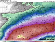
The big question is how widespread rains will be? I'm seeing large discrepancies in the guidance which keeps confidence low on how heavy the rain will be and where it's most focused. At least for now, guidance is not impressive with rain totals over much of my area. In fact, several show a split with most of the rain just north or south of the region. For my money, the far north in the morning and the southeast later in the day stands the best chance of getting the most organized convection (even in these areas totals are likely to vary substantially over short distances). Some spots may not see any at all. That's typical with late summer thunderstorms. Using a blend of all the models you get this for rain totals.

The EURO indicates this.

The GFS shows little if any rain indicating this.

The 12K NAM

The 3k NAM

Following the passage of the front Wednesday night rain chances diminish and drier air will advect into the region from the north. Dew points will go down at least 10 degrees. It all adds up to seasonably warm August weather Thursday and Friday with highs generally in the mid 80s, perhaps upper 80s far south.
Saturday winds return to the south opening the door to hot humid conditions. Signals are consistent among models that Saturday will be a cooker with highs in the low to mid 90s. Heat index values should reach or even exceed 100 degrees. Sunday sees some cooling in the north but the south remains hot. Here's what the EURO is indicating for highs Saturday and Sunday.
Saturday

Sunday

Weekend rain chances appear to hold off until Sunday when another cool front slowly approaches from the north. While that's a few days away the potential is there for some active storms containing some much needed rain, especially if we can get the dynamics to coincide with peak heating. The whole Sunday set-up should become clearer in the next 24-48 hours. Meantime, plan for a steamy weekend.
The long term forecast next week is a tale of two models, one good the other horrible. The GFS is once again barking at the moon showing extreme heat in the period August 10-18th. That my friends is fantasyland, the model is currently unusable.

The EURO shows a whole different ball game with highs in the 80-85 degree range where the GFS is 102-112.

Not only do I buy the cooler look of the EURO, it has support from the MJO (Madden Julian Oscillation). Notice during that period August 10-18 it is shown in phase 2 which in August correlates to cooler than normal temperatures.

That's the long and short of it. Enjoy your hump day and roll weather...TS


Comments