


BY THE HAIR OF OUR CHINNY CHIN CHIN...
- Apr 20, 2021
- 3 min read
Snowflakes have been noted around the area the past 24 hours but unless you are in my southern counties they haven't amounted to much more than bad memories. This shot was taken at the Iowa Cubs baseball stadium in Des Moines Monday morning. This imparts new meaning to the action of "sliding" into base!

This exceptionally cold air mass is so massive for this time of year that it actually proved too cold and dry for the majority of my area to see accumulating snow. The worst of the event is actually going to be further south where better moisture and forcing exists. Most of us will miss the action by the hair of our chinny chin chin. A big deal considering the historic potential of the snow accumulations that will be found just to the southeast.

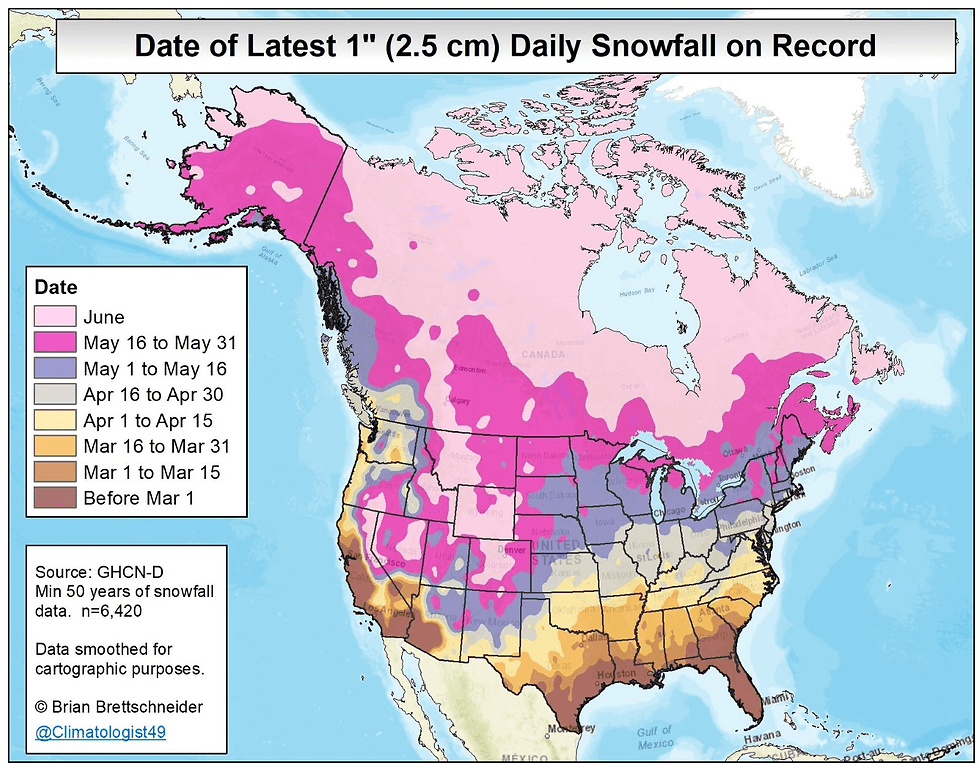
Where more than 1 inch of snow falls in places like eastern Kansas, Missouri, and Illinois, this could very well end up being the latest ever for such an occurrence.
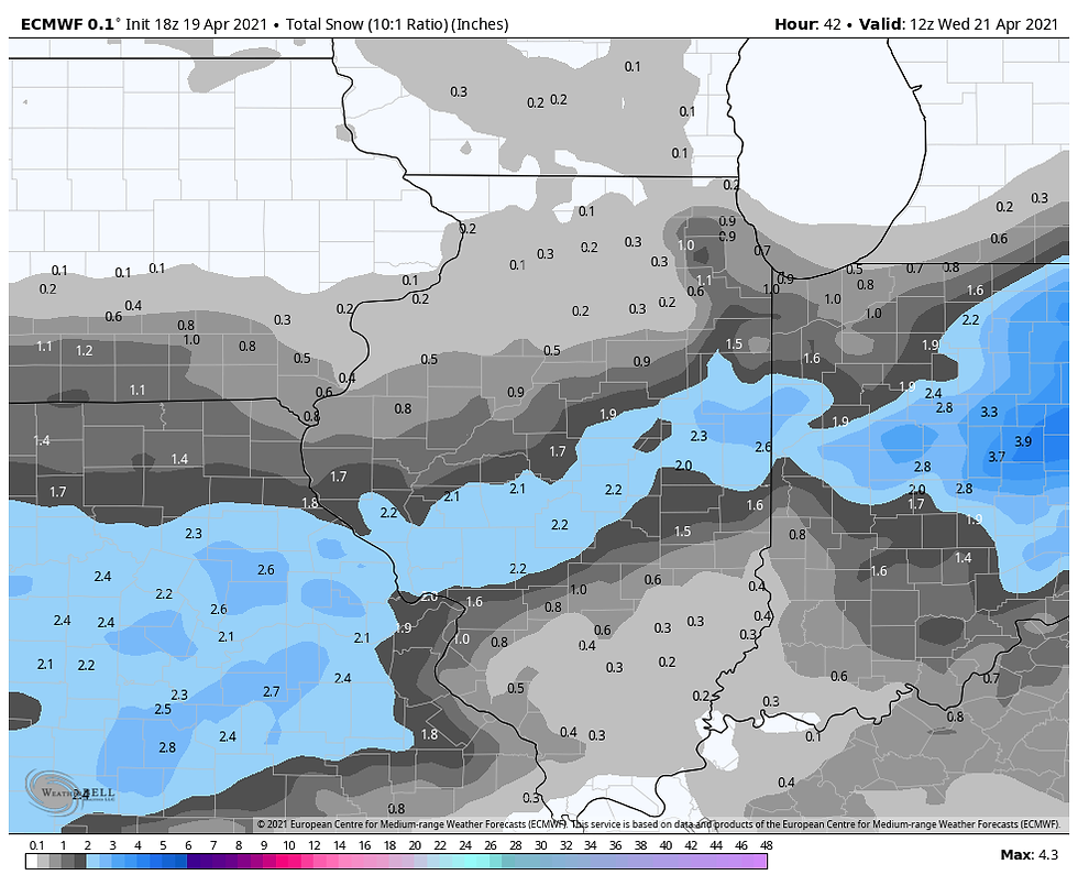
In my area, snow will be ongoing Tuesday morning generally near and south of HWY 34. Amounts of up to an inch are possible, perhaps a few nearing 2" closer to the Missouri border. If you are down that way, there could be a few slick spots but the bulk of the accumulations should be on grassy and elevated surfaces as opposed to roads. The latest models late Monday evening are showing accumulations that look like this.
The EURO
The GFS

The HRRR

The 3K NAM

The 12k NAM

Even where there is no snow north of HWY 34, there will still be a threat of snow showers popping up in the afternoon. 850 temperatures are ridiculously cold all day in the range of 8 to 9 below zero. Instability will be in place with shallow surface warming allowing steep lapse rates and at least scattered afternoon snow showers to pop, perhaps even a few squalls that could generate short but intense snowfall rates which could dust things up in spots. We will need to watch that concern. You can see the little specks scattered around the region on the HRRR that indicate snow showers, especially later in the day.

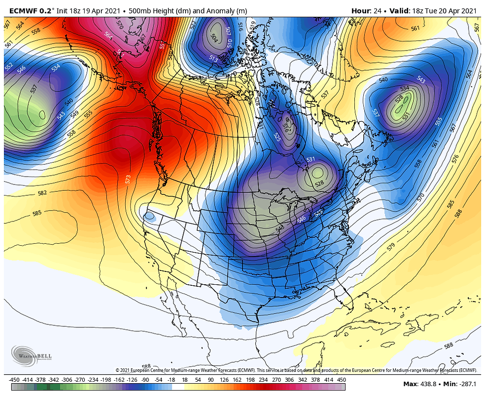
Then there's the cold which keeps things mighty darn fresh through Wednesday. You can clearly see why by observing the 500mb jet stream pattern . If you follow the air flow trajectory you can see it originates in the Arctic. Fortunately, the sun is quite strong this time of year which tempers the intensity of the cold. Had this been January the Arctic hounds would be howling. As it is we'll remain in the range of 40-45 Tuesday and Wednesday. A good 20 degrees below normal.
Lows both Wednesday and Thursday morning have the potential to plunge into the mid to upper 20s in many spots. A hard freeze is expected that will impact tender vegetation. A Freeze warning is already in effect for my entire region.

Temperatures will gradually moderate going into the weekend and next week as the MJO moves into phase 8 which for a time will bring welcome warmer weather. However, a rapid progression into phase 1 and 2 is projected which implies more below normal temperatures going into May. I'll have more on that unwelcome news in my next next post. Stay warm and for those of you who pick up some late season white gold, enjoy it for me. One thing I promise, it won't be around for long! Roll weather...TS


Comments