


COLDEST AIR OF THE SEASON
- Oct 19, 2025
- 2 min read

The coldest temperatures of the season are right around the corner as a powerful cold front will bring strong wind gusts and crashing temperatures. By Wednesday night/Thursday morning lows (above) are forecast to fall into the upper 20s/low 30s locally.

There will be a bit of a quick burst of warmth early Monday with gusty southerly winds before the cold front comes sweeping through switching the wind out of the northwest. Gusts could top 40-50mph especially Tuesday with strong cold air advection taking over. There's a pretty good chance we will see Wind Advisories issued across the region given the increasing probabilities of strong wind gusts.

By 9 a.m. Tuesday morning gusts will likely already be above 30mph based on the HREF mean. The HREF max is already over 40mph. Those inflatable Halloween decorations will certainly need to be turned off on Monday and Tuesday to survive.
High Pressure takes over calming the winds Wednesday and Thursday which will also allow temperatures to crash with perfect radiational cooling.

Wednesday morning lows will start the descent with temperatures dipping into the mid 30s/low 40s. Thursday temperatures at the top of the post have low 30s in place, with low-lying areas likely dipping into the upper 30s. Frost Advisories and Freeze Warnings are likely.

Friday morning will still be on the cold side with mid 30s likely across eastern Iowa and northern Illinois.
For some context, the coldest temperatures so far this autumn:
Dubuque
39° - Sept. 7
Cedar Rapids
39° - Oct. 9
Quad Cities
39° - Oct. 9
Burlington
40° - Oct. 9

Looking ahead, I am continuing to watch later this month for another shot of colder air, potentially leading towards a colder Halloween. The European Ensemble remains bullish with below-normal temperatures mid/late next week.

Analogs are showing about 60-70% probabilities for below normal temperatures in the Oct. 30 - Nov. 2 time frame as well which are based more on the American GEFS ensemble. Prior to this push of cool air there will be another stint of above-normal temperatures this upcoming weekend.
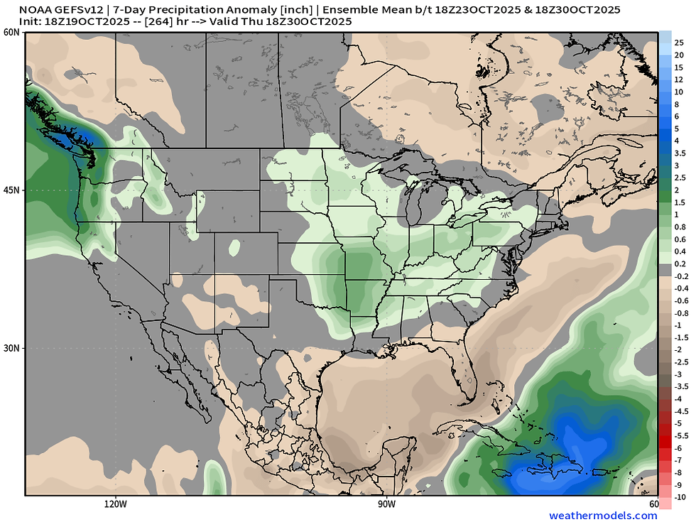
The GEFS is indicating a period of above-normal precipitation with this next storm system early next week, but notice a familiar scenes with the highest likelihood staying just south of the area.
The EURO

The GFS

Both the operational Euro and GFS indicate a fairly strong storm system early Next week in the Monday/Tuesday time frame. This could bring some heavy rain to the area in addition to some severe weather potential given the strong wind shear overhead. Instability will be questionable so it just remains a watch item for now, especially as we are a week out at this point still.
Missing out on spring storms? I put together a storm chasing documentary from my chase in eastern Colorado from late May. It featured a beautiful sunset tornado and some magnificent storm structure. Check it out if you are interested.
Have a great week friends!
-Meteorologist Nick Stewart


Comments