COLDEST PRE-CHRISTMAS SINCE 89...
- terryswails1
- Dec 16, 2022
- 3 min read
The details are still in the works but the potential is there for the coldest pre-Christmas weather since 1989. For those who don't recall, that December temperatures fell to 24 below zero in the Quad Cities on the 23rd. That is the all-time coldest temperature ever recorded during the month of December in the QCA. Santa needed the bun warmers that year! The Arctic surge brought record cold and snows to the deep south including Florida.

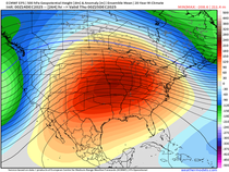
This December, a similar (but less extreme) set-up is taking shape with the ability to make the period December 22nd-24th the coldest in 33 years. Here is a look back at the 500mb upper air chart in December 23rd 1989.

Here's what's projected on the EURO this year. A very similar look.

In 1989 you can see the big 1052mb high driving the cold over Nebraska

December 23rd of this year, a comparable 1050mb high is in a similar position over the northern Plains.

There's little doubt 1989 is a strong analog for what is coming this year, especially when you consider the 89 cold was ushered in by a couple inches of snow. That could also happen this year. Again, what's coming in 2022 does not look as cold as 89 but it may be just a notch or two below it. Often times the past portends the future and that is why analogs can be helpful, especially in long range forecasting.
At least at this point, here is what the EURO is projecting for lows December 23rd.

The accompanying wind chills would be serious if indeed they materialize in the range of 35 to 40 below.

Getting back to the analogs, 1989 certainly appears to be the strongest candidate for what is coming this year. Again, the current set-up does not look as brutal but often times the past portends the future and that is why analogs can be helpful, especially in long range forecasting. As I've pointed out, there certainly is precedent for what is on the table.
Meantime, we continue to deal with the monster storm which has dumped tremendous snows over the upper Midwest. Here's some 36 hour totals ending Thursday evening.

Amounts in my area have have ranged from 1-2 inches in the far north to just a trace in the far south.

On the satellite Thursday evening, you can see the nearly stationary upper air low near Minneapolis spinning like a top. Vorticity (energy) rotating around the stacked system is creating the forcing necessary to generate light snow showers.

These spokes of energy will pass through the region into Saturday. That implies little change in our weather with wind, cold, and occasional snow showers continuing. Some minor accumulations of up to an inch are possible, especially in my northern counties near and north of HWY 30. The hi-res 3K NAM shows this for totals.

Now that we are back in the cold air, it's here to stay in varying degrees right on through Christmas. The troubles begin around December 21st when the Arctic front makes its approach. The EURO indicates four mornings with sub-zero lows in Cedar Rapids starting the 22nd and continuing right on through Christmas morning. Highs the 23rd remain well below zero.

As I mentioned snow chances are expected to come into play the 21st and 22nd. Several inches of powder seem possible with high snow ratios looking likely. This is the type of snow that would blow around easily and Arctic air masses like the one expected always bring wind. The concern would be blowing and drifting snow and severe wind chills creating difficult and dangerous conditions for pre-holiday travelers. I'm not trying to hype the set-up but things could get a little rough if worst case conditions are realized. If you are one of those who has to travel it might be a good idea to keep up on the situation and plan accordingly in the next few days. Hopefully trends will get better with time. No need to change your agenda yet.
By the way if you are curious, here's what models are suggesting for snow between now and Christmas including what falls the next couple of days. Remember, these are not forecasts. It's just raw model output that helps us derive forecasts as the event nears.
The EURO

The GFS

The Canadian GEM

I do need to stress that at best, confidence is moderate regarding snowfall and the depth of any Arctic intrusion at this distance. Even so, the chances for a white Christmas continue to improve. Here are the odds on the EURO of an inch or more of snow cover December 25th in my area. Chances in the south are 70-80 percent with the north 95-100 percent.

Well, I guess that's enough winter for anybody to swallow. Have a fantastic weekend and as always, roll weather...TS.


