COOKING UP SOME WARMTH...
- May 9, 2025
- 3 min read
A back door cold front brought E/NE winds to the region Thursday, slicing more than 20 degrees off high temperatures. Despite the cooler readings, the sun was out, it was another pleasant day. Here's the 24-hour change in temperatures from noon Wednesday to noon Thursday. The Quad Cities was down 26 degrees.

Another significant change was a drier air mass which scoured out any semblance of moisture. By Friday morning, available water vapor could be as low as 1/10th of an inch on the 3K NAM. That's about 20 percent of normal.

You can see going into Thursday night, skies were cloud free from Iowa and northern Illinois into Canada thanks to a sprawling area of high pressure and its dryness.

With the ridge axis directly overhead, the stage was set for maximum radiational cooling overnight. Light winds, fair skies, and very dry air will allow the atmosphere to cool to its full potential. The 3k NAM which does tend to run a tad cool, depicts lows Friday morning in the north down to 33 in Dubuque.

The GFS is a couple degrees warmer but still cold with a 35 in Dubuque and 30s down to I-80.

It's entirely possible some patchy frost could form, especially in low-lying locations like river valleys, where cold air drainage is common in the north. The saving grace is that the nights are short, which limits the time temperatures have to cool compared to December or January. I do not expect any frost issues locally to flowers or vegetation. That said, a frost advisory is out for counties just to the east into early Friday.

After the chilly start, Friday will turn into a sparkling day with wall-to-wall sunshine and a nice recovery in temperatures with afternoon highs of 66-70. Winds will be light and variable.
TERRY'S LITTLE WHITE CHURCH, AIRBNB IN GALENA
Check out some of the ways you can save as much as $400 dollars on a stay at my AIRBNB, a renovated church in Galena. It's a most loved guest favorite with perfect 5-star ratings. https://www.littlewhitechurchgalena.com/
COOKING UP SOME WARMTH...
Saturday, it's time to turn up the burners and bring in a round of early summer temperatures. What sets this up is a 500mb ridge over the upper Midwest. Sunday evening it's over northern Wisconsin, with rain making troughs in the Pacific NW and the deep south. Subsidence (sinking air) is actively occurring across the NC, United States.

Look what that does for temperatures during the period May 10th-17th.

One feature to watch is the upper air low in the deep south. The latest trends have shown a tendency to track it further NW, which allows passing clouds and perhaps some showers to clip the area Monday night and again Tuesday afternoon. These would be mainly diurnal, driven by daytime heating. They would tend to be hit-and-miss with coverage scattered if they make here. If the low wobbles more east, that implies even lower rain chances. For now, (very early in the game), the EURO shows this for rain. About a 1/4 inch more than its previous run.

The GFS is noticeably lighter and in my opinion more likely at this time.

What could be more problematic than any rain is cloud cover. If we see an increase in clouds, it could knock temperatures back. In fact, the wetter solution of the EURO has dropped readings Monday and Tuesday from the low 80s to the low to mid 70s. Wednesday, numbers are back up to the upper 70s and low 80s. Thursday, a pre-frontal day, shows a brisk SW flow and highs in the low to mid 80s. The EURO is actually hot, with highs of 90-95 south of I-80. A shower or storm is possible late Thursday or Thursday evening when the front crosses the region, especially in the north. After that, it's back to the mid to upper 70s Friday.
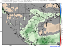
Even with 70s and 80s the next 8–9 days, forcing still does not look to be sufficient for widespread storms or heavy precipitation. These are the rainfall departures shown on the GFS and EURO the next 10 days ending May 18th. Most areas are indicated to be 1 to1.5 inches below normal.
The GFS

The EURO

CPC, the Climate Prediction Center, shows the above normal temperatures but rebels against the dryness showing above normal odds of precipitation.

It will be interesting to see how this contradiction is resolved. I'm leaning more towards a below normal resolution.
Keep those shades handy today, the sun is going to blaze. Let it shine and have a great weekend! Roll weather...TS


Comments