


EYES ON A POTENTIAL RECORD-WARM CHRISTMAS
- Dec 21, 2025
- 2 min read

The pattern setting up for Christmas week is looking historic. The strength of the ridge in the jet stream bringing record-warm temperatures for many is anticipated to be at records compared to climatology. Above you can see the 500mb char that looks more like a summertime death ridge than a wintertime pattern. All the bright red area is expected to see record-high 500mb heights, which is directly related to the major warmth at the surface.

The next five days are averaging about 5-8° above normal locally, with a large area of 10°+ anomalies situated just to the southwest. Virtually the entire Continental United States will be above normal this week, which will look nothing like Christmas in the region.

The model blend shows Christmas Day being, naturally, the warmest day in the extended outlook locally with highs potentially in the mid/upper 50s! I hope you took photos of your holiday decor in the snow last week because it is long gone by Thursday.

Current forecast highs Christmas day (above) are surging into the 50s and 60s locally, with highs in the 70s not too far away. Notice all the temperatures circled above - all those city's forecast highs will be within two degrees of a record high, which includes the Quad Cities, Des Moines, Quincy, IL and Springfield, IL in the local area. The number of record highs Thursday could be rather extreme across the Midwest and Plains.
The EURO

The GFS

Now there are some notable differences in the main players - the Euro is rather significantly cooler than the GFS on Thursday's temperatures. One of the major differences is how the models are interpreting the snowpack in the region and where it will be on Thursday.

A look at enhanced satellite imagery Saturday afternoon shows a good snowpack across much of the area (green). How much this melts by midweek will have a rather big impact on the overall temperature outlook. I personally think the GFS has a better handle on the melting process, and therefore temperatures, so I would favor the warmer solution.
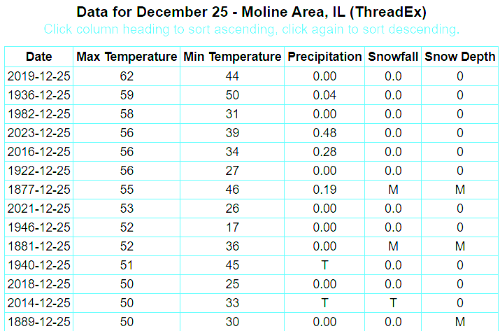
Looking at the Quad Cities you don't have to go back too far for the record. In 2019 Moline (the official climate site for the Q.C.) clocked 62°. Many recent years, in fact, are in this top list. Six of the top 13 years have happened since 2014, which is rather remarkable and is certainly troubling. This year will likely be s top-five finisher.

Jumping down the Mississippi River to Quincy, Illinois is also rather impressive. Six of the top-15 warmest Christmas days have happened since 2009. With a high projected in the mid-60s, more likely to be a record than the Quad Cities, four of the last six years would be in the top-10 warmest Christmas Days.

So far in December we are already running warm across the region. The east-central Iowa climate district for example is the 18th-warmest December so far, or in the top 86 percent of years. This will likely increase somewhat significantly in the coming days with the warm that is looming.
Those dreaming of a white Christmas will be out of luck and poor Frosty never stood a chance. Have a great Sunday, friends!
-Meteorologist Nick Stewart


Comments