


HAIR RAISING...
- Dec 5, 2024
- 4 min read
True story. I'm driving down the street Wednesday after taking my mom to see the doc. It's garbage day, and all the bins were lined up like little soldiers on the side of the road when we head out after noon. I had put mine in the garage before leaving, knowing big winds were coming. By now it's a couple of hours later, after 3:00, and the Manitoba mauler has arrived. It's blowing a gale, and we are on my street, nearly home. All of a sudden, the car gets rocked by a huge gust. I look out the side window and then back to the road and 2 feet ahead of me is a recycling bin grinding across the street. I swerved to miss it and I look at mom and say excitedly, wow, that had to be at least a 55mph gust. She looks a little shell shocked, holding tight to the door, and relates, you told me yesterday it was going to be a hair-raising day (at 95, you never know what soaks in with her). Anyway, I had to laugh because I'm sure she thought I was exaggerating. By the time I hit my garage, I counted 11 other big bins blown on their side.
I eventually learned that the peak gust in Dubuque was 57 mph. Waterloo topped out at 58. . Winds of that caliber in a thunderstorm would prompt a severe thunderstorm warning. It was rocking, and 6 hours later it still was, with gusts remaining close to 50 mph. Here are some reported top end speeds from the NWS in the Quad Cities.

PERTINENT UPDATE:
Just now, I see a new ASOS report from the NWS that shows a 66 mph gust at the Cedar Rapids Municipal Airport at 6:04 pm. That my weather friends is flat out impressive. The Quad City Airport in Moline now indicates a 58 mph gust, with Iowa City in at 56.

GET IN ON A HOT 40% OFF HOLIDAY DEAL AT OUR GALENA AIRBNB
Santa's secret destination to relax after his big night! (explore our new website as well)

GOING DOWN?
Crashing temperatures were another hallmark of the mauler. After a high of 44 in Waterloo around 2:00pm, the reading had plunged to 12 at 8:30, a 32 degree drop in 6.5 hours. Around 7:00am Thursday, most spots should be in the range of 7–11 degrees.

Wind chills we be flat out nasty starting Thursday around 6-12 below zero.

By then, the snow showers that flared up due to the intense cold air advection will be gone. However, some of the narrow plumes Wednesday produced short, but intense snowfall, with visibility restricted to under a mile for short periods of time. Most places saw little more than a dusting thanks to the rapid movement of the squalls. Here's one showing up on radar around 9:00pm. Hard to predict something precisely when it's no more than 15 miles wide. However, if you are under it, you feel like you are in the middle of a snow globe.

Last but not least, here's the Arctic front passing southeast of the Quad Cities around 2:00pm. Behind it lags the bitter cold air and snow showers which rapidly followed.

Fortunately, this is a quick hitter and the cold and winds gradually ease off by Thursday afternoon. Highs should eventually reach the upper teens NE to lower 20s elsewhere. Unfortunately, wind chills will remain in the single digits most of the morning before rising into the low to mid-teens in the afternoon with mostly sunny skies.
HOORAY FOR THE WEEKEND
I am happy to say the weekend will see substantial improvement as the upper level winds veer in from the west, allowing a more moderate brand of temperatures Saturday and Sunday. Highs should get into the 40s both days, with low 50s quite possible in the south Sunday. Dry conditions will attend the mild temperatures. Good weather for Christmas shoppers.
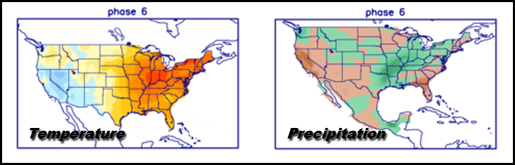
Next week the pattern begins to show a more progressive nature as well as some retrogression. With time, we should break out of this NW flow for a week or two, with temperatures eventually going above normal. Before that happens, though, we are likely to see one more healthy dump of cold air the middle of next week. Beyond that, the MJO enters the dreaded phase 6, remaining there December 15th-30th.

Here are the phase 6 analogs in December. If you are looking for snow at Christmas, you do not want to see phase 6 show up. It generally portends a W/SW storm track that provides resistance to cold, which in turn very much hurts snow prospects. I've been promoting this idea for some time now, and I just keep hoping models show a flip or a faster MJO progression, but so far that has not happened.
The EURO ensemble shows this for temperature departures December 16th, certainly reminiscent of what phase 6 is known for.

The 500mb storm track that same day on the EURO ensembles. Jeepers, that's painful to look at if you like winter weather, especially snow.

The EURO shows this for total accumulations through December 20th. Bad sledding!

All right then, with the wind still howling and the temperature at 9 and the wind chill 11 below, I'm thankful to have a warm place to sleep. Off I go. Roll weather...TS


Comments