HIP, HIP, HOORAY, IT'S MAY
- May 1, 2025
- 3 min read
Nothing says spring to me like the arrival of May. March and April have their good days, but it seems to me there are more worse days than good. Finally, we are cooking with solar gas. The sun has been getting stronger for four months, and just an average day gets you a high of at least 70. From the standpoint of consistently mild temperatures, we are over the hump and summer is just a hop skip and a jump away. My motto, if it ain't gonna snow, it might as well be 80. Welcome, May....
By the way, here's the breakdown of high temperatures for every month of the year. In the Quad Cities, the biggest month-to-month gain in average high temperatures occurs from April to May (53.5 degrees to 69.61 degrees).

I should also mention, this is the only time of year I can get my favorite meal. That's a fresh batch of moral mushrooms (deep-fried), a mess of slab blue gills or crappie, fried potatoes, and my mom's rhubarb pudding. I'm 3 pounds heavier just thinking about it. The morals are out, and the fish are starting to hit. There's work to be done, junior!

STILL UNSETTLED
The current pattern shows a plume of rich moisture overspreading the Midwest, as evidenced by the thick canopy of clouds on the satellite.

Water vapor Wednesday evening ranged from 1.00 inch north to 1.4 inches south. A series of disturbances will punch through this over the next 48 hours, providing the forcing to kick up showers and perhaps a few thundershowers. One impulse went through the region Wednesday but with dry air to overcome, saturation was a challenge and what rain fell through evening was light and concentrated more on my southeast counties. Doppler rainfall estimates show this for rain through 9:00 PM Wednesday.

Now the moisture is in place, as shown by the available water vapor of 1" plus to Minnesota and Wisconsin.

It all adds up to what should be some nice rains over much of the region. Between now and Friday evening, most spots should see at least a half an inch, with the potential of an inch or more swiping parts of my area. It's showing up consistently on the rainfall guidance of most models. Take a look.
The EURO

The GFS

The HRRR

The 12K NAM

The 3K NAM

The rain comes in waves, meaning there will be breaks when it won't fall. That said, there appears to be three primary windows where the majority of it occurs. The first batch is exiting early Thursday morning. Another round is possible late in the afternoon and evening Thursday. The final wave arrives Friday afternoon and evening, more focused on the southern half of my area. Due to extensive cloudiness and periods of rain, temperatures Thursday and Friday should be held in check to the range of 65 to 70.
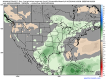
The final raindrops are out of the area Friday night, and that should close the door on significant rain chances for approximately a week. These are the rainfall departures for the 7-day period May 3rd through May 9th. Lots of high pressure in our future.

Additionally, enough ridging is expected next week to allow some very pleasant May temperatures. The meteograms of both the GFS and EURO are trending up next week. The GFS is nice and warm, but the EURO is a little less bullish. We'll need to watch the trends, but it certainly appears next week will be mild.
The GFS

The EURO

The Climate Prediction Center is certainly leaning in that direction in its 6-10 day outlook, with above normal temperatures and below normal precipitation..

That's the scoop for now. Patience is the name of the game the remainder of this week. The big pay-off comes after that. Have a fine day and roll weather...TS.


Comments