HIT AND RUN...
- Sep 4, 2024
- 7 min read
Another stunning day of weather graced the Midwest Wednesday. Sunny skies, meager humidity, and highs in the 70s are the stuff of smiles, and I'm sure there were plenty of those to go around. This was the 4th consecutive day in Dubuque where highs have held in the range of 74-76, with nary a cloud to be found. Choice!

Looking back at this year's temperatures to date, it's plain to see that it's been a mild year across the state of Iowa with all but the far west averaging 2–5 degrees above average. Interestingly enough, the core of the warmth was centered in the NE quadrant.

When you look at the specific numbers, 125 of our 248 days in Dubuque have experienced highs in the range of 70-89 degrees (about 50%). The very good news is that extreme heat, days 90 or above have been at a minimum. So far the hottest of the 4 days was 94, which did tie a record.

One thing few places have seen in recent summers is a 100 degree high. Here in Dubuque, the last time we hit the century mark was July 26th of 2012 (a stretch of 4,423 days which continues to grow). To break the all-time record we have a long way to go though. Back on August 12th of 1941, after eclipsing 100, readings never got that hot again until June 19th of 1988, a period of 17,114 days (almost 5 decades).

A ONE-DAY BOUNCE
Thursday will be a day of what could be classified as summery conditions thanks to a pre-frontal draw of SW winds. Temperatures should punch into the low to mid 80s in most area. Clouds will increase in the afternoon, especially across the north with the approach of a cold front. The associated forcing should spark a few showers and perhaps some rumbles of thunder as the front advances southeast. Some skinny instability tries to get established but with CAPE less than 500 j/kg vigorous updrafts will be tough to support.

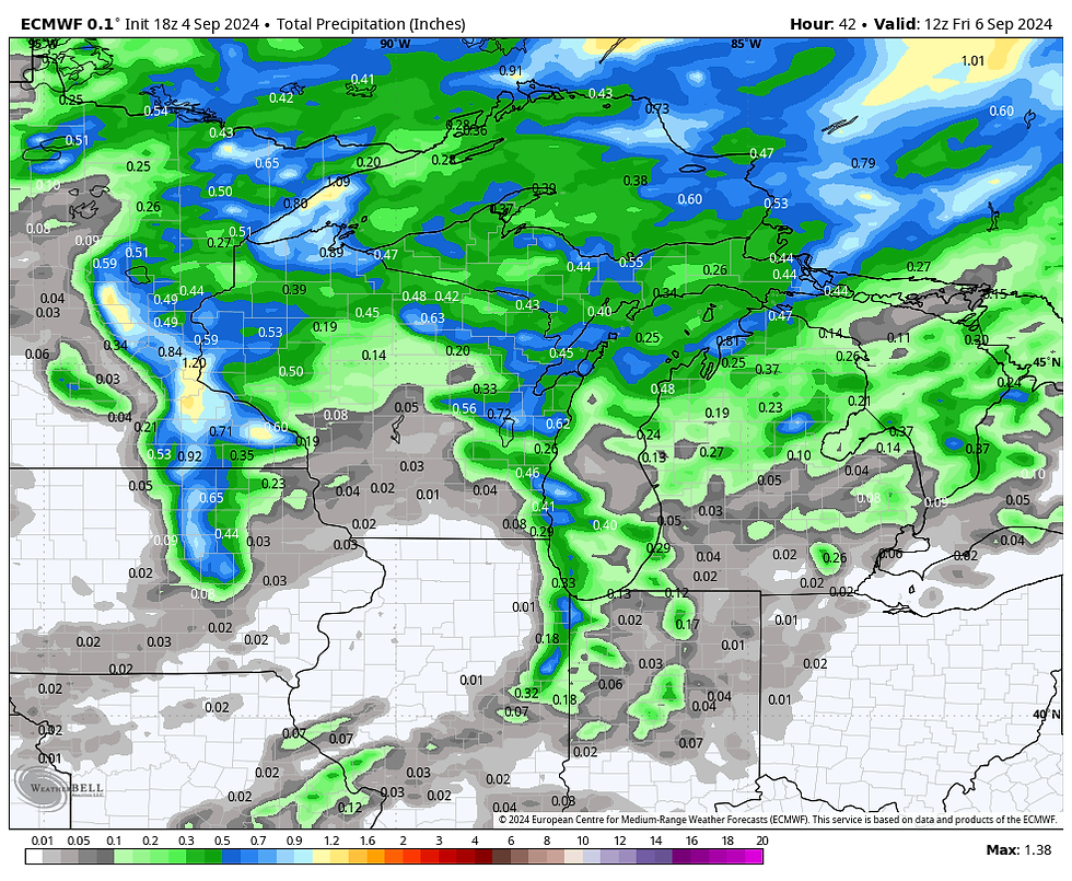
With meager moisture, instability, and the rapid movement of the front, rainfall is expected to be light. Some spots could scare up 1/4" but in most places amounts will be considerably less. Here's what guidance is suggesting for rain totals. The convective allowing models such as the HRRR and 3k NAM are the most aggressive on amounts, particularly in the south. That is questionable.
The EURO

The GFS

The HRRR

The 3k NAM

NOW THAT'S WHAT I CALL A DOWNER...
Behind the front a stout upper air low digs into the Great Lakes driving a quick but potent shot of cold air into region.

The cold core circulation rotates over the area Friday afternoon and night dropping 850 temperatures to 3 degrees C. That type of cold air aloft will no doubt generate strong lapse rates that creates afternoon cumulus or pockets of stratus Friday afternoon.

The extent of the clouds could impact Friday's temperatures, especially in the northeast where some low to mid 60s are possible. A few brief light showers are also possible. However, most areas should see enough sun to reach the upper 60s with some low 70s in the far south. North winds of 15-25 deliver the cool air. Check out the big 1030mb high building over Canada.

Cold air advection kicks in big time Friday night allowing skies to clear and winds to decrease in the late evening. Temperatures should tank and lows of 40-45 seem to be a good bet, especially if winds taper off quickly after sunset. The GFS has this for lows.

Around daybreak Saturday it has wind chills in the 30s for many. Ugh...

I suspect it's too cold and a worst case scenario, but the 3k NAM has lows Saturday morning in the 30s as far south as I-80. It shows Decorah Iowa down to 32. Some readings in WC Wisconsin are shown in the mid 20s! We would need perfect radiational cooling to see anything close to what the 3k is depicting.

Later Saturday the high shifts east allowing return flow by afternoon. With full sunshine highs remain cool with readings in the range of 65 north to 70 south. Sunday and Monday look exceptional with highs in the low 70s Sunday and mid to upper 70s Monday. Bottom line, this round of chilly air will be of the hit-and-run variety.
After that, upper level ridging builds into the Midwest ensuring a warming trend that carries us through next week. The EURO shows the warmth building with 80s back in the area Tuesday though Friday.

The NWS 8-14 day outlook shows a strong chance of above normal temperatures along with below normal rainfall September 12-18th.

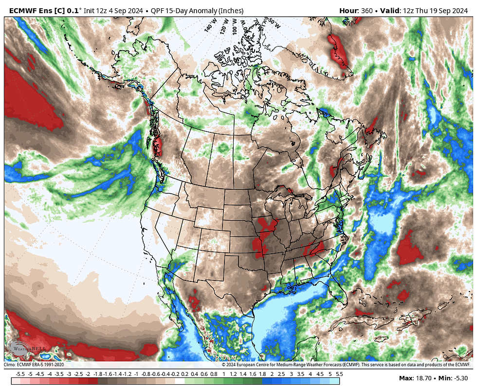
As I pointed out yesterday, it appears we are going into an extended period of dry weather the next 2 weeks, which I am sure farmers will appreciate with crops maturing. Most of the area east of the Rockies is shown with much below normal precipitation. These are the departures through September 20th.
The GFS

The EURO

That's all for this go round. Make it a fruitful day and roll weather...
PEOPLE LOVE IT. OUR AIRBNB IS A MOST LOVED GUEST FAVORITE!
ANOTHER 5-STAR REVIEW....thanks Myriam
AIRBNB has rated my renovated church in Galena A GUEST FAVORITE, A MOST LOVED home according to visitors. Check out some of our reviews and get in on the flexible deals we have available below.
Christa-Monument, Colorado
The Little White Church is amazing!!!! Pictures do not do it justice. I would absolutely recommend it to my friends and family. It is just so unique. Carolyn is an amazing host and super responsive. I would give our experience 6 out of 5 stars if I could.
Phillip-Queensland, Australia
Amazing and thoughtful renovation. Stayed in a piece of history. Great location and modern amenities. Would stay again!
Jill
The Little White Church is beautiful. The decorations are perfect, and it was redone with impeccable taste. Carolyn was a great host.
Brent
Such a gem. Relaxing in the countryside in a historic church that was beautifully decorated and recently renovated was exactly what we experienced. Everyone loved our stay, and we will be back!!!
Leigh
Beautiful and unique. We were all captivated by the adorable chapel turned AIRBNB
Jenny-Frisco, Texas
It was a magical place for our family to celebrate Christmas!
Kelly
What a gem! The Little White Church exceeded our expectations. It was the perfect spot to meet up with another couple to relax and explore nearby Galena. We enjoyed the beautiful great room with its fireplace and amazing views of the rolling countryside. (The photos simply can't do it justice). The charming church/home was quiet, well appointed and clean. And Carolyn was proactive with instructions and a terrific communicator. We will definitely be back!
John
Absolutely incredible! Loved the tranquility and the beautiful views. The decor was so inviting. AND the bell tower works!! Would 100% stay here again!
Tori-Cedar Falls
This place is so beautiful! Carolyn and Terry were so thoughtful and kind to let us have our wedding at the church. They even provided extra supplies in case we needed them. The private garden worked perfectly for our ceremony, and the backyard easily fit our reception needs. Not to mention, the balconies make perfect photo spots! My husband and I recommend the Little White Church and will be telling all our friends about it.
Mahesh-Buffalo Grove
Carolyn was a great host, very flexible! The place is super clean, spacious with a private backyard overlooking the fields and bluffs! We spent a lot of time on the deck. Great kitchen, clean bedrooms and baths. Highly recommend the place.
William
Great place. Great host. Will definitely book again and tell our friends.
Miriam
Carolyn and Terry's place is BEAUTIFUL! The Little White Church is a wonderful place, way more beautiful than the pictures. Everything is brand new and extremely clean. Staying at the church was a unique experience and I would love to come back soon. I strongly recommend the place if you are looking for a 5-star location!
Vanessa-Chicago
Carolyn was great! Absolutely beautiful place! I would not hesitate to go back. We spent Thanksgiving and the next night. Very well stocked and above and beyond with extras included. Thank you!
MAKE US AN OFFER...
What about pricing? Right now, we are able to offer you our best pricing ever. We have 3 nights for the price of 2 which, depending on the days, can save as much as $300-$400 dollars. If you book directly through us, you can also eliminate booking fees and taxes that the big chains charge. Cleaning fees are also drastically reduced. It all adds up to exceptional deals at a destination worth visiting. Let us assist in finding a time and price that works for you. Here's a link to some pictures. https://www.tswails.com/galena-airbnb
Carolyn and I will do all we can to make sure your stay is a memorable one. Please call or text Carolyn for more details and options and get a prime date while they are still available. Again, that's Carolyn at 563-676-3320. Or carolynswettstone@yahoo.com
Now that it's vacation season, there is no better place to visit than Galena and no better place to stay than my newly renovated AIRBNB, the Little White Church. We are located in the bluffs, just 5 miles from the 2nd largest tourism destination in Illinois. In fact, "Tourist Destination", rated Galena as the 2023 top place to visit in the entire Midwest.
Now is the best time to enjoy all there is to offer, and my 5-star AIRBNB is the perfect location to stay. Set in the rolling hills just outside of town, our completely renovated church is designed for you to unwind and relax.
Again, we are an AIRBNB Super host and can accommodate up to 8 guests. We've got cable, hi-speed WIFI, Sirius XM and a sparkling full kitchen. We are a home away from home and take great pride in cleanliness and comfort. All of our ratings have attained perfect 5-star status!
Hope to see you soon,
Terry and Carolyn
7 GREAT REASONS TO VISIT GALENA
1. It’s Steeped In History
2. It’s Home To One Of The Best Main Streets In America
3. The Restaurants Are Amazing
4. There’s A Lot To Do Outdoors
5. You Don’t Have To Travel To The Mountains To Go Skiing
6. It’s A Great Place To Spend The Fourth Of July
7. Did I Mention The Shopping?


Comments