


HOW YOU LIKE ME NOW...
- Aug 1, 2025
- 3 min read
We've locked up the steam and packed it away for another time. In its wake, some sensational weekend conditions are headed our way that will feature chamber of commerce weather highlighted by well below normal temperatures, a bit of a rarity the first few days of August.
Before we get to that, I see that the powers that be, have classified the high wind producing storms of Monday night a derecho. A few years ago, most people in Iowa (and much of the Midwest) didn't even know what a derecho was. However, thanks to the August 10th, 2020 inland hurricane that battered the state with winds up to 140 mph, everybody pretty now is pretty much aware a derecho is a wind force to reckon with.
Technically, A derecho is a widespread, long-lived, and damaging windstorm associated with a line of thunderstorms. To be classified as a derecho, a storm must meet specific criteria that includes a damage swath extending at least 240 miles long, wind gusts of at least 58 mph along its path, and the presence of multiple thunderstorm wind gusts of 75 mph or greater, separated by 80 miles.
Monday night's Derecho reached the necessary criteria. Once it formed in SE South Dakota, it arched E/SE into eastern Iowa before dissipating not far from the Quad Cities. You can see the individual storm reports and warnings issued for the line of storms that produced consistent damage for 12 hours, starting at 4:00pm the 28th and ending around 4:00am the 29th.

Here are some of the higher gust reported across northern Iowa.
99 MPH – Near Sioux Center, IA
92 MPH – Near Orange City, IA
87 MPH – Spencer Municipal Airport
83 MPH – Cedar Rapids, IA
80 MPH – Janesville, IA
78 MPH – Waterloo Regional Airport
77 MPH – Independence, IA
By the way, the term derecho was originated by an Iowan, Gustavus Hinrichs. Living in Iowa City in 1877, he coined the term after studying a number of such storms pass across Iowa. Many believed the damage they caused was due to tornadoes, but Hinrichs rightly proved they were straight line winds caused by a line of powerful, fast moving storms. His hand drawn analysis of the original 1877 derecho is shown below.


Derecho's are not common, but certainly not unheard of in Iowa. Since 1980, at least a dozen significant events have been reported within the state.
PLAN A TRIP TO MY 5 STAR GALENA AIRBNB

My 5-STAR AIRBNB just outside of Galena still has some openings this summer. All of our ratings are 5 star! We take pride in the amenities and the cleanliness. If you book now, we'll take off $200, and we can eliminate AIRBNB fees and additional costs that will save you big bucks. Other discounts apply. Call or text Carolyn at 563-676-3320 for our best deal of summer. See more at https://www.littlewhitechurchgalena.com/
COOL, STORM FREE DAYS...
After an active start to the week, it was nice to have a storm/rain free day Thursday. However, what would have been a stellar day was somewhat tempered by the effects of Canadian wildfires. NE winds pulled in smoke that created a pronounced haze, reducing visibilities considerably. The smokes milky signature shows up nicely on this afternoon satellite imagery.

Friday, some lingering smoke is still possible, but the hope is it will mix out some. The HRRR shows the heavier concentrations Friday further to the west and south.

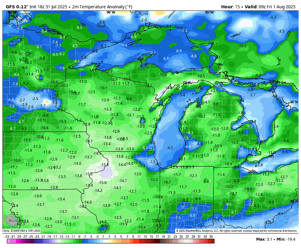
No matter what, Friday starts nice and crisp with lows according to the GFS that reach the low to mid 50s.

Readings that cool August 1st are about 14–15 degrees below normal.
Later in the day Friday, with some haze from smoke, highs will rebound to the range of 73-77. What a change, especially with dew points early in the day in the mid to upper 40s. Just a few days ago they were as high as 80!

Little change is expected the rest of the weekend and probably Monday. Sensational conditions are expected, with highs in the mid to upper 70s and lows well into the 50s. Mostly sunny skies will accompany the nice readings. My air conditioning is already on vacation.
For at least the next 7 days, precipitation also looks meager as we flip the switch from wet to dry. The EURO shows this for total rain through next Thursday.

Most of the Midwest and points east are well below normal on 7 day precipitation. Here are the departures.

While we won't see much active weather, return flow signals the return of warmer and gradually more humid weather mid-week and beyond. The EURO echoes that trend with its idea of highs pushing 90 by next weekend.

Here's to a new month and a new brand of weather. We finally put a damper on the ring of fire. Happy Friday and roll weather...TS


Comments